Product successfully added to your shopping cart
There are 0 items in your cart. There is 1 item in your cart.
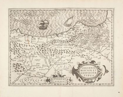
Legionis Biscaiae et Guipiscoae typus
Jodocus Hondius (*1563 - †1612)Reference 12957
Description
Beautiful antique map of northern Spain by J. Hondius. Shows the northern Spanish coastline with the Basque Country, Castile and León. With the provinces of Asturias and Cantabria on the Bay of Biscay, as well as La Rioja, Burgos and Palencia. In the east, the upper reaches of the Ebro. With Gijón, Santander, Bilbao, Biarritz, Bayonne, Miranda, Burgos and Logroño.
Decorated with two cartouches and two sailing ships. This example comes from the French edition of the Mercator-Hondius Atlas printed in 1633.
Details
| Cartographer | Jodocus Hondius |
| Title | Legionis Biscaiae et Guipiscoae typus |
| Publisher, Year | H. Hondius, Amsterdam, 1633 |
| Plate Size | 35.0 x 47.2 cm (13.8 x 18.6 inches) |
| Sheet Size | 47.9 x 57.0 cm (18.9 x 22.4 inches) |
| Reference | Van der Krogt, P.: Koeman's Atlantes Neerlandici, 6010:1A |
Condition
Cartographer
Images to Download
If you like to download the image of this map with a resolution of 1200 pixels, please follow the link below.
You can use this image for publication on your personal or commercial websites for free if you set a link to this website. If you need photographs with a higher resolution, please contact us.
Spain - Portugal - Hondius, Jodocus - Legionis Biscaiae et Guipiscoae typus

![Tabula nova Hispaniae [Tabula noua Hispaniae] Tabula nova Hispaniae [Tabula noua Hispaniae]](https://www.vintage-maps.com/3236-home_default/fries-spain-portugal-1541.jpg)

![[Canary Islands] [Canary Islands]](https://www.vintage-maps.com/3021-home_default/bordone-spain-portugal-canaries-tenerife-gran-canaria.jpg)
