Product successfully added to your shopping cart
There are 0 items in your cart. There is 1 item in your cart.
North - South Pole

Barbara Codonea - Germaniae Latus Septentrionale
Sodalitas Celtica, Nuremberg, 1502
One of the Earliest Depictions of the Arctic Ocean. Printed in 1502.Very rare first edition of the woodcut map of Central and Northern Europe with the early depiction of the Arctic Ocean by...
Barbara Codonea - Germaniae Latus Septentrionale
1502 - Konrad Celtis
12465Early woodcut map of Northern and Central Europe. Printed in Nuremberg by Sodalitas Celtica in 1502.
7 800,00 €
Geographische Universal-Zeig und Schlag-Uhr
J.B. Homann, Nuremberg, circa 1720
Curious Depiction of California as an Island.Illustration of a geographical clock by Zacharias Landteck, who manufactured it in the early 1700's in Nuremberg. The engraving was created by J....
Geographische Universal-Zeig und Schlag-Uhr
1720 - Johann Baptist Homann
11496Old coloured map of California as an Island. Printed in Nuremberg by J.B. Homann circa 1720.
980,00 €
Hemisphere Meridional pour voir plus distinctement Les Terres Australes...
Covens & Mortier, Amsterdam, circa 1730
Fine old coloured map of the Southern Hemisphere. First published by Guillaume de L'Isle in 1714, this is the edition by Covens and Mortier printed in Amsterdam around 1730. It shows the complete...
Hemisphere Meridional pour voir plus distinctement Les Terres Australes...
1730 - Guillaume de l'Isle
12444Old coloured map of the Southern Hemisphere, Australia. Printed in Amsterdam by Covens & Mortier circa 1730.
900,00 €
Septentrionalium Regionum Descrip.
Antwerp, 1584
Fascinating and important map of the North Atlantic by A. Ortelius in stunning original colours.Showing Scandinavia, Siberia and the Arctic regions in the East, the British Isles with the...
Septentrionalium Regionum Descrip.
1584 - Abraham Ortelius
11436Old coloured map of the North Pole, North Atlantic. Printed in Antwerp in the year 1584.
Sold
Septentrionalium Regionum Descrip.
Christoffel Plantin, Antwerp, 1587
Ortelius' famous and important map of the North Atlantic. With stunning old colours.The famous and probably the most beautiful map of the North. Shows the North Atlantic with Scandinavia and...
Septentrionalium Regionum Descrip.
1587 - Abraham Ortelius
12682Old coloured map of the North Pole, North Atlantic. Printed in Antwerp by Christoffel Plantin in 1587.
Sold
Septentrionalium Terrarum Descriptio
Jodocus Hondius, Amsterdam, 1613
The First Separate Printed Map of the North Pole and the Arctic Regions.The first printed map devoted exclusively to the Arctic. First published after Gerard Mercator's death (1594) by his...
Septentrionalium Terrarum Descriptio
1613 - Gerard Mercator
12431Antique map of the North Pole and the Arctic. Printed in Amsterdam by Jodocus Hondius in 1613.
Sold
Septentrionalium Terrarum Descriptio
Henricus Hondius, Amsterdam, 1628
The First Separate Printed Map of the North Pole and the Arctic Regions.The first printed map devoted exclusively to the Arctic. First published after Gerard Mercator's death (1594) by his...
Septentrionalium Terrarum Descriptio
1628 - Gerard Mercator
12782Antique map of the North Pole and the Arctic. Printed in Amsterdam by Jodocus Hondius in 1628.
Sold
Poli Arctici et Circumiacentium Terrarum descriptio novissima
Amsterdam, 1638
Very attractive Polar map by Henricus Hondius. It was publish first 1636 for the English edition of the Mercator Hondius Atlas after the Mercator map of the North Pole from 1595 became obsolete....
Poli Arctici et Circumiacentium Terrarum descriptio novissima
1638 - Jodocus Hondius
10145Old coloured map of the North Pole. Printed in Amsterdam in the year 1638.
Sold
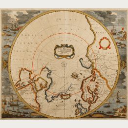
Regiones Sub Polo Arctico
Joan Blaeu, Amsterdam, 1643-50
Old coloured sea chart of the North Pole by Willem Blaeu. With Greenland and Canada, Iceland, Spitsbergen, Norway and the north coast of Russia. The map shows, the famous Northwest Passage , a...
Regiones Sub Polo Arctico
1643 - Willem Janszoon Blaeu
12043Old coloured sea chart of the North Pole. Printed in Amsterdam by Joan Blaeu in 1643.
Sold
Nova et Accurata Poli Arctici et Terrarum Circum Iacentium Descriptio
Johannes Janssonius, Amsterdam, 1650
Old colored sea chart of the North Pole by J. Janssonius. With Greenland and Canada, Iceland, Spitsbergen, Norway and the north coast of Russia. The map shows, the famous Northwest Passage , a...
Nova et Accurata Poli Arctici et Terrarum Circum Iacentium Descriptio
1650 - Johannes Janssonius
11920Old coloured sea chart of the North Pole. Printed in Amsterdam by Johannes Janssonius in 1650.
Sold
Nova et Accurata Poli Arctici et terrarum Circum Iacentium Descriptio
Janssonius Heirs, Amsterdam, 1666
Old colored sea chart of the North Pole by J. Janssonius. With Greenland and Canada, Iceland, Spitsbergen, Norway and the north coast of Russia. The map shows, the famous Northwest Passage , a...
Nova et Accurata Poli Arctici et terrarum Circum Iacentium Descriptio
1666 - Johannes Janssonius
12042Old coloured sea chart of the North Pole. Printed in Amsterdam by Janssonius Heirs in 1666.
Sold
Terre Artiche.
Venice, 1691
A beautiful and rare map showing the Arctic circle, the northern parts of America, Europe, Russia and Siberia. Only northern half of Iceland is shown. A central circular panel of text is surrounded...
Terre Artiche.
1691 - Vincenzo Maria Coronelli
11471Antique map of the North Pole. Printed in Venice in the year 1691.
Sold
Hemisphere Meridional pour voir plus distinctement les Terres Australes
Paris, 1714
First edition of the important map of the southern hemisphere by de l'Isle in early strong colours, first published in 1714. This early map of the South Polar regions became the standard map for...
Hemisphere Meridional pour voir plus distinctement les Terres Australes
1714 - Guillaume de l'Isle
11296Old coloured map of Australia, South Polar Region. Printed in Paris in the year 1714.
Sold
Facies Poli Arctici adiacentiumque ei regionum ex recentissimis itinerariis delineata cur...
Johann Ernst Adelbulner, Nuremberg, 1718
Old coloured map of the North Pole by Christoph Weigel. Shows the northern polar area with Greenland and Canada, Iceland, Spitsbergen, Norway and the north coast of Russia. From Bequemer Schul-...
Facies Poli Arctici adiacentiumque ei regionum ex recentissimis...
1718 - Christoph Weigel
11953Old coloured map of the North Pole. Printed in Nuremberg by Johann Ernst Adelbulner in 1718.
Sold
Facies Poli Antarctici ex recentissimis itinerariis descripta a. Christophoro Weigelio
Johann Ernst Adelbulner, Nuremberg, 1718
Old coloured map of the South Pole by Christoph Weigel. Shows the southern polar region with the tip of South America ( Tierra Del Fuego, Cape Horn), the Strait of Magellan and the Le Maire Strait....
Facies Poli Antarctici ex recentissimis itinerariis descripta a....
1718 - Christoph Weigel
11954Old coloured map of the South Pole. Printed in Nuremberg by Johann Ernst Adelbulner in 1718.
Sold
Hemisphere Septentrional pour voir plus distinctement Les Terres Arctiques...
Covens & Mortier, Amsterdam, circa 1730
Fine old coloured map of the Northern Hemisphere. First published by Guillaume de L'Isle in 1714, this is the first edition by Covens and Mortier printed in Amsterdam around 1730, still without the...
Hemisphere Septentrional pour voir plus distinctement Les Terres...
1730 - Guillaume de l'Isle
12443Old coloured map of the Northern Hemisphere, Polar Region. Printed in Amsterdam by Covens & Mortier circa 1730.
Sold
A New & Accurate Map of the North Pole, with All the Countries Hitherto Discovered Situated Near...
E. Bowen, London, 1747
Attractive Arctic and sub-Arctic map of Emanuel Bowen from 'A Complete System of Geography'. Excellent detailed around Hudson Bay, Greenland, Spitzbergen, north-east coast of Europe & Asia and the...
A New & Accurate Map of the North Pole, with All the Countries Hitherto...
1747 - Emanuel Bowen
11036Antique map of the North Pole. Printed in London by E. Bowen in 1747.
Sold
Aequator sive linea Aequinoctialis
circa 1770
A very rare double hemisphere world map in unusual polar equidistant projection.Based on the coastline of Australia and New Zealand, one would expect a period of origin in the late 17th...
Aequator sive linea Aequinoctialis
1770 - Anonymous
11742Old coloured map of the world. Printed circa 1770.
Sold


