Product successfully added to your shopping cart
There are 0 items in your cart. There is 1 item in your cart.
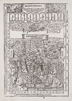
Barbara Codonea - Germaniae Latus Septentrionale
Konrad Celtis (*1459 - †1508)Reference 12465
Description
One of the Earliest Depictions of the Arctic Ocean. Printed in 1502.
Very rare first edition of the woodcut map of Central and Northern Europe with the early depiction of the Arctic Ocean by Konrad Celtis, printed in 1502. From Quatuor libri amorum, one of the most beautiful and interesting German woodcut books of the time. The woodblock for this map was cut by Hans Süss of Kulmbach, student of the painter Jacopo de Barbari, and a close friend and assistant of Albrecht Dürer.
The woodcutsketch gives a panoramic view of the area between the Rhine in the west, the Vistula in the east and in north-south extension from the Danube to the Arctic Ocean. Many of the northern islands and peninsulas of Celtis’s map can also be found on the famous world map of the Cosmographia by Holle, printed 1482 in Ulm. Among them are Thule (Tyle), which probably represents one of the Shetland Islands, Iceland (Islandi), Scandia and Gottia. In the northeastern part of the ocean is an unnamed island, which probably already represents the Spitsbergen (Svalbard) archipelago.
Leonid S. Chekin wrote in his paper A Russian discovery in the Arctic Ocean at the time Columbus for the ICHC 2009 :
Thus, a study of Celtis's contacts, the fourth book of his Amores and the Germania generalis, and his Barbara Codonea map demonstrates that the humanist played a key role in transmitting knowledge about the northernmost "island" that was mentioned in narrative sources of the late fifteenth century and that some scholars understand as Spitsbergen.
Latin text on verso.
Details
| Cartographer | Konrad Celtis |
| Title | Barbara Codonea - Germaniae Latus Septentrionale |
| Publisher, Year | Sodalitas Celtica, Nuremberg, 1502 |
| Plate Size | 21.7 x 15.2 cm (8.5 x 6.0 inches) |
| Sheet Size | 25.0 x 18.0 cm (9.8 x 7.1 inches) |
| Reference | The Map Collector, Issue 74, pp.18-21, illus. p.21.; Piechocki, K.N.: Cartographic Humanism - The Making of Early Modern Europe; Chekin, L.S.: A Russian discovery in the Arctic Ocean at the time Columbus, Conference paper at the 23rd International Conference on the History of Cartography; Meurer, P.H.: Cartography in the German Lands, 1450–1650, History of Cartography, Fig. 42.8. |
Condition
Cartographer
Konrad Celtis, also Conrad Celtis, born as Conrad Bickel 1459 in Wipfeld, Franconia. He was a humanistic scholar and poet of the Renaissance. He studied in Cologne, Heidelberg, Padua, Ferrara, Bologna, Florence, Venice and Rome.
Celtis was not only important as a poet, but also as a geographer and editor. He discovered the 12th century medieval copy of a late Roman road map and handed it over to his friend Konrad Peutinger around 1507. Today this copy of the ancient Roman road map is known as Tabula Peutingeriana or Peutinger's Tabula. After Peutinger's death a copy was made by a member of the family, which was published by Abraham Ortelius in 1598.
His main work is considered to be the Quattuor libri amorum, which was first published in Nuremberg in 1502. Each of the four books opens with a map drawn by Celtis himself. The woodcuts of the maps were made in the circle of Albrecht Dürer and were cut by Dürer's assistant Hans Süß von Kulmbach (Hans Suess).
Celtis died 1508 in Vienna and was buried in St. Stephen's Cathedral.
Images to Download
If you like to download the image of this map with a resolution of 1200 pixels, please follow the link below.
You can use this image for publication on your personal or commercial websites for free if you set a link to this website. If you need photographs with a higher resolution, please contact us.
Europe Continent - Celtis, Konrad - Barbara Codonea - Germaniae Latus...

![[Map of Europe] [Map of Europe]](https://www.vintage-maps.com/2931-home_default/bordone-europe-continent-1528-1565.jpg)
