Product successfully added to your shopping cart
There are 0 items in your cart. There is 1 item in your cart.
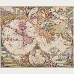
Antique World Maps

Ptolemaisch General Tafel, begreiffend die halbe Kugel der Welt.
Heinrich Petri, Basle, 1540 (1578)
Early Ptolemaic woodcut world map by Sebastian Münster. With a surround of clouds and wind-heads. Title on verso surrounded by a beautiful woodcut border. From the German edition of Sebastian...
Ptolemaisch General Tafel, begreiffend die halbe Kugel der Welt.
1540 - Sebastian Münster
12837Ptolemaic woodcut world map by Sebastian Munster. Published by Heinrich Petri in Basel in 1578.
1 800,00 €![Münster, World Map, 1550 [1578]: Das Erst General, inhaltend die beschreibung und den Circkel des gantzen Erdtrichs und Möre]( "Sebastian Münster: Das Erst General, inhaltend die beschreibung und den Circkel des gantzen Erdtrichs und Möre")
Das Erst General, inhaltend die beschreibung und den Circkel des gantzen Erdtrichs und Möre
Heinrich Petri, Basle, 1550 [1578]
16th Century Woodcut Map of the World.Early woodcut world map by Sebastian Münster. This 'modern' map of the world is an oval projection with a vigorous surround of clouds and lusty...
Das Erst General, inhaltend die beschreibung und den Circkel des gantzen...
1550 - Sebastian Münster
1283816th century woodcut map of the world. Printed in Basle by Heinrich Petri in 1578.
3 200,00 €
Typus Orbis Terrarum, Americae sive Novi Orbis, Nova Descriptio, Africae Tabula Nova, Asiae Nova...
Gielis Coppens van Diest, Christoffel Plantin, Antwerp, 1573-1584
Ortelius' World and Continents from the First Modern Atlas.A fine set consisting of a world map and four of the continents from the first modern atlas Theatrum Orbis Terrarum by Abraham...
Typus Orbis Terrarum, Americae sive Novi Orbis, Nova Descriptio, Africae...
1573 - Abraham Ortelius
12683Old coloured world map and continent maps by Abraham Ortelius. Published in 1573-84 in Antwerp.
18 000,00 €
Doctrina de ponderibus, monetis et mensuris per totum terrarum orbem usitatis.
Johann Nicolaus Stoltzenberger, Frankfurt, 1628
Two rare sets of octant globe gores printed on 4 sheetsTwo sets of globe gores in a projection based on Leonardo da Vinci's idea. Bound into Angelocrator's work on surveying techniques,...
Doctrina de ponderibus, monetis et mensuris per totum terrarum orbem...
1628 - Daniel Angelocrator
11222Antique map of the world. Printed in Frankfurt by Johann Nicolaus Stoltzenberger in 1628.
4 800,00 €
P. Merulae Cosmographiae Partis II ... Europa & speciatim Hispania describitur.
W. Blaeu, Amsterdam, 1635
Titlepage of Cosmographiae Generalis by Paulus Merula. With a small woodcut of a terrestrial and celestial globe on a beam balance. Printed 1635 by Willem Blaeu in Amsterdam.
P. Merulae Cosmographiae Partis II ... Europa & speciatim Hispania...
1635 - Willem Janszoon Blaeu
12636Woodcut of a title page. Printed in Amsterdam by W. Blaeu in 1635.
35,00 €
Nova Totius Terrarum Orbis Geographica ac Hydrographica Tabula auct: Guiljelmo Blaeuw.
Amsterdam, 1641-49
One of the Most Famous World Maps of Dutch Cartography with Stunning Old Colours.Perhaps the finest world map ever printed. This map represents the apogee of seventeenth century Dutch...
Nova Totius Terrarum Orbis Geographica ac Hydrographica Tabula auct:...
1641 - Willem Janszoon Blaeu
12865Old coloured world map with borders by Willem J. Blaeu. Published 1643 in Amsterdam.
14 000,00 €
Nova Totius Terrarum Orbis Tabula ex Officina F. de Wit Amstelodami
Frederick de Wit, Amsterdam, 1668-70
Engraved by the Dutch Master Romeyn de Hooghe.Rare first state of Frederick de Wit's fine maritime world map. One of the most decorative world maps of the 17th century and maybe the best...
Nova Totius Terrarum Orbis Tabula ex Officina F. de Wit Amstelodami
1668 - Frederick de Wit
12754Antique world map by Frederick de Wit, engraved by Romeyn de Hooghe. Published in Amsterdam around 1668.
5 900,00 €
Geographische Universal-Zeig und Schlag-Uhr
J.B. Homann, Nuremberg, circa 1720
Curious Depiction of California as an Island.Illustration of a geographical clock by Zacharias Landteck, who manufactured it in the early 1700's in Nuremberg. The engraving was created by J....
Geographische Universal-Zeig und Schlag-Uhr
1720 - Johann Baptist Homann
11496Old coloured map of California as an Island. Printed in Nuremberg by J.B. Homann circa 1720.
980,00 €
Atlas novus terrarum orbis imperia regna et status exactis tabulis geographice demonstrans
J. B. Homann, Nuremberg, circa 1720
Old coloured title page of Johann Baptist Homann's atlas Atlas novus terrarum orbis imperia regna et status exactis tabulis geographice demonstrans published around 1720 in Nuremberg.Shows...
Atlas novus terrarum orbis imperia regna et status exactis tabulis...
1720 - Johann Baptist Homann
11808Copper engraving of a title page. Printed in Nuremberg by J. B. Homann circa 1720.
490,00 €
Hemisphere Meridional pour voir plus distinctement Les Terres Australes...
Covens & Mortier, Amsterdam, circa 1730
Fine old coloured map of the Southern Hemisphere. First published by Guillaume de L'Isle in 1714, this is the edition by Covens and Mortier printed in Amsterdam around 1730. It shows the complete...
Hemisphere Meridional pour voir plus distinctement Les Terres Australes...
1730 - Guillaume de l'Isle
12444Old coloured map of the Southern Hemisphere, Australia. Printed in Amsterdam by Covens & Mortier circa 1730.
900,00 €
Introduction a la Geographie
Covens & Mortier, Amsterdam, circa 1730
Small engraved map of the western hemisphere and the northern sky on a title page by Covens and Mortier.
Introduction a la Geographie
1730 - Covens and Mortier
12619Antique map of the world. Printed in Amsterdam by Covens & Mortier circa 1730.
190,00 €![Anonymous, Korean Manuscript Atlas, Chonha-Chido, 1800: Ch'onha Chido [Atlas of all under Heaven]]( "Anonymous: Ch'onha Chido [Atlas of all under Heaven]")
Ch'onha Chido [Atlas of all under Heaven]
circa 1800
A Scarce Korean Manuscript Atlas.Rare Korean manuscript atlas with 12 maps, produced around 1800. With a world map (Chonha-Do) with China in the center, a map of China with Korea, a map of...
Ch'onha Chido [Atlas of all under Heaven]
1800 - Anonymous
12834Korean Manuscript Atlas, Ch'onha-Chido, around 1800
8 000,00 €![Anonymous, Korean Manuscript Atlas, Chonha-Chido, 1820: Ch'onha Chido [Atlas of all under Heaven]]( "Anonymous: Ch'onha Chido [Atlas of all under Heaven]")
Ch'onha Chido [Atlas of all under Heaven]
circa 1820
A Scarce Korean Manuscript Atlas.Album with 11 manuscript maps from a traditional Korean manuscript atlas, drawn in the early 19th century. With a China-centered world map (Chonha-Do), a map...
Ch'onha Chido [Atlas of all under Heaven]
1820 - Anonymous
12082Korean Manuscript Atlas, Ch'onha-Chido, early 19th Century
9 500,00 €
In Principio creavit Deus celum et terra...
Anton Koberger, Nuremberg, 1493
The Book of Chronicles or Liber Chronicarum by Hartmann Schedel, also called Schedel's World History or Nuremberg Chronicle , starts with the creation of the world by God according to the...
In Principio creavit Deus celum et terra...
1493 - Hartmann Schedel
12145Collection of 4 sheets of the history of creation, Genesis, printed by H. Koberger 1493 in Nuremberg.
Sold![Schedel, The Last Judgement, 1493: Ultima etas mundi [The Last Judgement]]( "Hartmann Schedel: Ultima etas mundi [The Last Judgement]")
Ultima etas mundi [The Last Judgement]
Anton Koberger, Nuremberg, 1493
The Last Judgement, one of the most sought-after woodcuts of the Book of Chronicles or Liber Chronicarum by Hartmann Schedel, also called Schedel's World History or Nuremberg Chronicle ....
Ultima etas mundi [The Last Judgement]
1493 - Hartmann Schedel
12146The Last Judgement from Liber Chronicarum by Hartmann Schedel printed 1493 in Nuremberg.
Sold![Schedel, Ptolemaic World Map, February 1497: [Schedel's World Map - Secunda etas mundi - Folium xiii]]( "Hartmann Schedel: [Schedel's World Map - Secunda etas mundi - Folium xiii]")
[Schedel's World Map - Secunda etas mundi - Folium xiii]
Johann Schönsperger, Augsburg, February 1497
Scarce Incunabulum Woodcut Map of the World Printed in 1497.Early Ptolemaic woodcut world map by Hartmann Schedel. A reduced version of the world map from Schedel's World Chronicle, printed...
[Schedel's World Map - Secunda etas mundi - Folium xiii]
1497 - Hartmann Schedel
12677Incunabulum woodcut world map by Hartmann Schedel. Published 1497 by Johann Schönsperger in Augsburg.
Sold![Bordone, World Map, 1528-1565: [World map]]( "Benedetto Bordone: [World map]")
[World map]
Venice, 1528-1565
Early woodcut world map by Benedetto Bordone. The world map of Bordone combines geographical information from Ptolemy with new discoveries of the Portuguese seafarers. It is one of only a few world...
[World map]
1528 - Benedetto Bordone
12192Antique woodcut map of the world. Printed in Venice between 1528 and 1565.
Sold
Tabu. Nova Orbis / Diefert Situs Orbis Hydrographorum Ab Eo Quem Ptolomeus Posuit
M. & G. Trechsel, Lyon, 1535
The second 'modern' world map of L. Fries. 'This map is one of the earliest world maps available to a collector, and is an unsophisticated but attractive rendering of what was generally known of...
Tabu. Nova Orbis / Diefert Situs Orbis Hydrographorum Ab Eo Quem...
1535 - Laurent Fries
10865Antique woodcut map of the world. Printed in Lyon by M. & G. Trechsel in 1535.
Sold
Ptolemaisch General Tafel, begreiffend die halbe Kugel der Welt
Heinrich Petri, Basle, 1540 (1574)
Early Ptolemaic woodcut world map by Sebastian Münster. With a surround of clouds and wind-heads. Title on verso surrounded by a beautiful woodcut border. From the German edition of Sebastian...
Ptolemaisch General Tafel, begreiffend die halbe Kugel der Welt
1540 - Sebastian Münster
11322Ptolemaic woodcut world map by Sebastian Munster. Published by Heinrich Petri in Basel in 1574.
Sold
Ptolemaisch General Tafel, begreiffend die halbe Kugel der Weldt
Heinrich Petri, Basle, 1540 (1550)
Early Ptolemaic woodcut world map by Sebastian Münster. Surrounded by clouds and wind-heads. The title on verso is surrounded by a beautiful woodcut border. From the German edition of Sebastian...
Ptolemaisch General Tafel, begreiffend die halbe Kugel der Weldt
1540 - Sebastian Münster
12470Ptolemaic woodcut world map by Sebastian Munster. Published by Heinrich Petri in Basel in 1550.
Sold
Ptolemaisch General Tafel, begreiffend die halbe Kugel der Welt
Heinrich Petri, Basle, 1540 (1550)
Early Ptolemaic woodcut world map by Sebastian Münster. With a surround of clouds and wind-heads. Title on verso surrounded by a beautiful woodcut border. From the German edition of Sebastian...
Ptolemaisch General Tafel, begreiffend die halbe Kugel der Welt
1540 - Sebastian Münster
12609Ptolemaic woodcut world map by Sebastian Munster. Published by Heinrich Petri in Basel in 1550.
Sold
Nuevo Mundo
Francisco Frenandez de Cordova, Valladolid, 1545
Real First Edition of Medina's Very Rare Map of America and the Atlantic.Very rare and important first edition of the map of America and the Atlantic from Pedro de Medina's Arte de Navegar...
Nuevo Mundo
1545 - Pedro de Medina
12549Woodcut sea chart of the Atlantic Ocean. Printed in Valladolid by Francisco Frenandez de Cordova in 1545.
Sold![Ortelius, World Map, 1570 [1572]: Typus Orbis Terrarum]( "Abraham Ortelius: Typus Orbis Terrarum")
Typus Orbis Terrarum
Gielis Coppens van Diest, Antwerp, 1570 [1572]
The first World Map in the First Regular Atlas - with Old Colours.A fine old coloured and early example of one of the most famous world maps ever published. From the first modern atlas...
Typus Orbis Terrarum
1570 - Abraham Ortelius
12681Antique map of the world by Abraham Ortelius. Published in 1572 in Antwerp.
Sold
Descrittione del Mappamondo
Simon Galignani, Girolamo Porro, Venice, 1572
First edition of Porcacchi's antique map of the world. This is a finly-executed reduction of Camocio's large world map of 1567, one of the last in the long line of derivatives from Gastaldi's...
Descrittione del Mappamondo
1572 - Tomaso Porcacchi
12360Antique map of the world. Printed in Venice by Simon Galignani, Girolamo Porro in 1572.
Sold

![Münster, World Map, 1550 [1578]: Das Erst General, inhaltend die beschreibung und den Circkel des gantzen Erdtrichs und Möre](https://www.vintage-maps.com/4309-home_default/muenster-world-map-1550-1578.jpg "Sebastian Münster: Das Erst General, inhaltend die beschreibung und den Circkel des gantzen Erdtrichs und Möre")


![Anonymous, Korean Manuscript Atlas, Chonha-Chido, 1800: Ch'onha Chido [Atlas of all under Heaven]](https://www.vintage-maps.com/4291-home_default/anonymous-korean-manuscript-atlas-chonha-chido-1800.jpg "Anonymous: Ch'onha Chido [Atlas of all under Heaven]")
![Anonymous, Korean Manuscript Atlas, Chonha-Chido, 1820: Ch'onha Chido [Atlas of all under Heaven]](https://www.vintage-maps.com/3336-home_default/anonymous-korean-manuscript-atlas-chonha-chido-1820.jpg "Anonymous: Ch'onha Chido [Atlas of all under Heaven]")

![Schedel, The Last Judgement, 1493: Ultima etas mundi [The Last Judgement]](https://www.vintage-maps.com/2876-home_default/schedel-the-last-judgement-1493.jpg "Hartmann Schedel: Ultima etas mundi [The Last Judgement]")
![Schedel, Ptolemaic World Map, February 1497: [Schedel's World Map - Secunda etas mundi - Folium xiii]](https://www.vintage-maps.com/3827-home_default/schedel-ptolemaic-world-map-february-1497.jpg "Hartmann Schedel: [Schedel's World Map - Secunda etas mundi - Folium xiii]")
![Bordone, World Map, 1528-1565: [World map]](https://www.vintage-maps.com/2925-home_default/bordone-world-map-1528-1565.jpg "Benedetto Bordone: [World map]")


![Ortelius, World Map, 1570 [1572]: Typus Orbis Terrarum](https://www.vintage-maps.com/3849-home_default/ortelius-world-map-1570-1572.jpg "Abraham Ortelius: Typus Orbis Terrarum")
