Product successfully added to your shopping cart
There are 0 items in your cart. There is 1 item in your cart.
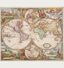
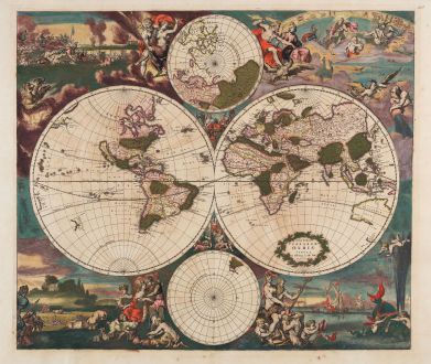
Nova Totius Terrarum Orbis Tabula ex Officina F. de Wit Amstelodami
Frederick de Wit (*1630 - †1706)Reference 12754
Description
Engraved by the Dutch Master Romeyn de Hooghe.
Rare first state of Frederick de Wit's fine maritime world map. One of the most decorative world maps of the 17th century and maybe the best example of the Dutch Golden Age of mapmaking. From De Wit's maritime atlas Orbis Maritimus Ofte Zee Atlas, printed around 1668.
R. Shirley describes this map in The Mapping of the World, Plate 327 (Entry 444), as follows:
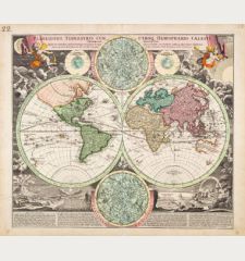
Somewhat unusually the two main hemispheres have been engraved and the surrounding illustrations etched. In the corners are large and lively scenes allegorically representing the four elements. Fire is shown by war and destruction; air by the heavens; earth by harvesting and husbandry; and water by ships and a spouting whale. There are groups of figures between the hemispheres and, above and below them, two smaller polar maps.
The discoveries around Australia made by Tasman on his first and second expedition in 1642-44 are included. New Zealand is drawn with one coastline only. California is shown as an island, the West Coast of North America beyond California is missing.
After De Wit's death in 1706, the plate of this world map was acquired by Louis Renard and reused for his atlases in 1715 and 1739 (state 2). After Renard, the plate was brought and revised by R. & J. Ottens and used in 1745 (state 3). Finally in 1802, the plate was used again by the widow of G. H. van Keulen (state 4). The map also served as a prototype for many mapmakers. Based on this map, a world map by J. Danckerts (Shirley 495) was published in 1680, a second Danckerts world map in 1685 (Shirley 529). Gerrit van Schagen (1682), Joachim Boormeester (1685) and David Funke (1700) also used the De Wit map as a prototype.
Details
| Cartographer | Frederick de Wit |
| Title | Nova Totius Terrarum Orbis Tabula ex Officina F. de Wit Amstelodami |
| Publisher, Year | Frederick de Wit, Amsterdam, 1668-70 |
| Plate Size | 48.1 x 56.2 cm (18.9 x 22.1 inches) |
| Sheet Size | 52.5 x 62.0 cm (20.7 x 24.4 inches) |
| Reference | Shirley, R. W.: The Mapping of the World, No. 444 |
Condition
Cartographer
Images to Download
If you like to download the image of this map with a resolution of 1200 pixels, please follow the link below.
You can use this image for publication on your personal or commercial websites for free if you set a link to this website. If you need photographs with a higher resolution, please contact us.
World Maps - Wit, Frederick de - Nova Totius Terrarum Orbis Tabula ex...

![Ch'onha Chido [Atlas of all under Heaven] Ch'onha Chido [Atlas of all under Heaven]](https://www.vintage-maps.com/3336-home_default/anonymous-korean-manuscript-atlas-chonha-chido-1820.jpg)
![Ch'onha Chido [Atlas of all under Heaven] Ch'onha Chido [Atlas of all under Heaven]](https://www.vintage-maps.com/4291-home_default/anonymous-korean-manuscript-atlas-chonha-chido-1800.jpg)
