Product successfully added to your shopping cart
There are 0 items in your cart. There is 1 item in your cart.
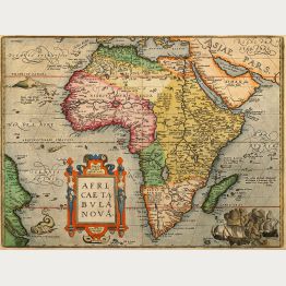
Africa
![Fries, North Africa, 1525: [Tab. Mo. Primae Partis Aphricae et Tabula Secunde partis Aphricae.]]( "Laurent Fries: [Tab. Mo. Primae Partis Aphricae et Tabula Secunde partis Aphricae.]")
[Tab. Mo. Primae Partis Aphricae et Tabula Secunde partis Aphricae.]
Johannes Grüninger, Strasbourg, 1525
Early woodcut map of North Africa by Laurent Fries after Martin Waldseemüller. Shows the the northern and western part of the continent. This woodcut map comes from the 1525 Strasbourg edition of...
[Tab. Mo. Primae Partis Aphricae et Tabula Secunde partis Aphricae.]
1525 - Laurent Fries
11887Antique woodcut map of North Africa. Printed in Strasbourg by Johannes Grüninger in 1525.
1 500,00 €![Münster, Africa Continent, 1540 [1578]: Africa Lybia Morenlandt mit allen königreichen so zu unsern zeiten darin gefunden werden.]( "Sebastian Münster: Africa Lybia Morenlandt mit allen königreichen so zu unsern zeiten darin gefunden werden.")
Africa Lybia Morenlandt mit allen königreichen so zu unsern zeiten darin gefunden werden.
Heinrich Petri, Basle, 1540 [1578]
A very fine example of the earliest obtainable printed map to show all of Africa. First published in 1540 by Sebastian Munster, this map is also famous because of its rich mythical content. The...
Africa Lybia Morenlandt mit allen königreichen so zu unsern zeiten darin...
1540 - Sebastian Münster
12839Coloured woodcut map of the African continent. Printed in Basle by Heinrich Petri in 1578.
2 300,00 €
Natoliae, quae olim Asia Minor Nova Descriptio - Aegypti Recentior Descriptio - Carthaginis...
Antwerp, 1570
Coloured copper engraved map of Turkey by A. Ortelius. On right side a map of Egypt and one of Tunis. Three map on one sheet printed from one plate. From the early 1570 Latin edition of 'Theatrum...
Natoliae, quae olim Asia Minor Nova Descriptio - Aegypti Recentior...
1570 - Abraham Ortelius
10853Coloured map of Tunis, Egypt, Cyprus, Turkey. Printed in Antwerp in the year 1570.
420,00 €
S. Lorenzo - Descrittione dell'Isola di S. Lorenzo.
Simon Galignani, Girolamo Porro, Venice, 1572
First edition of Porcacchi's very attractive and early map of Madagascar. This finely-executed map shows the island of Madagascar in the Indian Ocean with north to the left. With a compass rose, a...
S. Lorenzo - Descrittione dell'Isola di S. Lorenzo.
1572 - Tomaso Porcacchi
12365Antique map of Madagascar, S. Lorenzo. Printed in Venice by Simon Galignani, Girolamo Porro in 1572.
250,00 €
Algier
Heinrich Petri, Basle, 1574
Early woodcut view of Algier, Algeria, North Africa. From the German edition of Sebastian Münster's Cosmography, Cosmographey oder beschreibung aller Länder , on the full page. The sheet was...
Algier
1574 - Sebastian Münster
11530Antique woodcut town view of Algier, Algeria. Printed in Basle by Heinrich Petri in 1574.
120,00 €
Von den Stetten Mauritanie
Heinrich Petri, Basle, 1574
Early woodcut view of ancient Cirta, today Constantine in Algeria, North Africa. From the German edition of Sebastian Münster's Cosmography, Cosmographey oder beschreibung aller Länder , on the...
Von den Stetten Mauritanie
1574 - Sebastian Münster
11531Antique woodcut town view of Cirta, Constantine, Algeria. Printed in Basle by Heinrich Petri in 1574.
30,00 €![Münster, Egypt, Nile River, 1574: [Nile River delta]]( "Sebastian Münster: [Nile River delta]")
[Nile River delta]
Heinrich Petri, Basle, 1574
Beautiful woodcut map of the Nile River delta by Sebastian Münster. Shows the Mediterranean coast with parts of the Gulf of Suez. With Alexandria in the West, Cairo with the Pyramids of Giza in the...
[Nile River delta]
1574 - Sebastian Münster
11681Coloured woodcut map of the Nile River. Printed in Basle by Heinrich Petri in 1574.
Out of stock230,00 €
Quiloa
Nicolas Chesneau, Michel Sonnius, Paris, 1575
A scarce and early woodcut view of Kilwa Kisiwani, formerly called Quiloa by the Portuguese, today belongs to Tanzania. Ruled in brown ink. As a woodcut view, it is extremely fine cut. On the full...
Quiloa
1575 - Francois de Belleforest
11417Antique woodcut town view of Quiloa, Kilwa Kisiwani, Tanzania. Printed in Paris by Nicolas Chesneau, Michel Sonnius in 1575.
190,00 €
Cefala
Nicolas Chesneau, Michel Sonnius, Paris, 1575
A scarce and early woodcut view of Cefala or Sofala, Mozambique. Once an important trading port at the mouth of the Sofala River in Portuguese East Africa. Ruled in brown ink. As a woodcut view, it...
Cefala
1575 - Francois de Belleforest
11418Antique woodcut town view of Sofala, Cefala, Mozambique. Printed in Paris by Nicolas Chesneau, Michel Sonnius in 1575.
190,00 €
Arzilla
Nicolas Chesneau, Michel Sonnius, Paris, 1575
A scarce and early woodcut view of Asilah, Morocco. Ruled in brown ink. As a woodcut view, it is extremely fine cut. On the full text sheet. Based on the Asilah view of Braun and Hogenberg. The...
Arzilla
1575 - Francois de Belleforest
11421Antique woodcut town view of Asilah, Morocco. Printed in Paris by Nicolas Chesneau, Michel Sonnius in 1575.
190,00 €
Sala
Nicolas Chesneau, Michel Sonnius, Paris, 1575
A scarce and early woodcut view of Salé, Morocco. Ruled in brown ink. As a woodcut view, it is extremely fine cut. On the full text sheet. Based on the Salé view of Braun and Hogenberg. The view...
Sala
1575 - Francois de Belleforest
11422Antique woodcut town view of Sale, Morocco. Printed in Paris by Nicolas Chesneau, Michel Sonnius in 1575.
190,00 €
Warhaffte abcontrafehtung der Mechtigen und Vesten Statt Alkair
Heinrich Petri, Basle, 1578
Early woodcut view of Cairo in Egypt by Sebastian Münster. Showing the city from a birdeye perspective with the Pyramids of Giza, the Great Sphinx of Giza, crocodiles and ships in the Nile River....
Warhaffte abcontrafehtung der Mechtigen und Vesten Statt Alkair
1578 - Sebastian Münster
12925Antique woodcut town view of Cairo. Printed in Basle by Heinrich Petri in 1578.
150,00 €
Abissinorum sive Pretiosi Ioannis Imperiu
H. Hondius, Amsterdam, 1633
This beautifully coloured antique map of central Africa focuses on the legendary kingdom of Christian Prester John. It follows the cartography style of Ortelius and is based on the travels of...
Abissinorum sive Pretiosi Ioannis Imperiu
1633 - Jodocus Hondius
12874Coloured map of East Africa. Printed in Amsterdam by H. Hondius in 1633.
690,00 €
Aphrodisium
Fürst, Nuremberg, 1638
Cooper engraved view of Bone in Tunisia from D. Meisner "Sciographia Cosmica" printed 1638 in Nuremberg. With Latin and German aphorism.
Aphrodisium
1638 - Daniel Meissner
10604Antique town view of Bone, Tunisia. Printed in Nuremberg by Fürst in 1638.
80,00 €
Pascaart, Waer in men claarlyck zien can, alle havens rivieren droogten, gelegen tusschen C.S....
Johannis Janssonius, Amsterdam, 1650
Rare and very decorative sea chart of the Atlantic coast of North Africa. Shows the coastline from southern Portugal to Gibraltar and North Africa from Morocco to Gambia. With the Canary Islands...
Pascaart, Waer in men claarlyck zien can, alle havens rivieren droogten,...
1650 - Johannes Janssonius
11864Coloured sea chart of the Atlantic Ocean. Printed in Amsterdam by Johannis Janssonius in 1650.
750,00 €
Totius Africae Accuratissima Tabula Authore Frederico de Wit
Amsterdam, circa 1680
Beautiful antique map of Africa by Frederick de Wit. This map became extremely popular for more than 30 years and was reissued with minor changes by Danckerts, Visscher and others. With a very...
Totius Africae Accuratissima Tabula Authore Frederico de Wit
1680 - Frederick de Wit
12417Coloured map of the African continent. Printed in Amsterdam circa 1680.
1 200,00 €
Novissima et Perfectissima Africae Descriptio
J. Danckerts, Amsterdam, circa 1685
Antique map of Africa by Justus Danckerts. Based on the map of Africa by Frederick de Wit. With an extremely decorative title cartouche and beautiful old coloring.Crafted by the esteemed...
Novissima et Perfectissima Africae Descriptio
1685 - Justus Danckerts
12860Old coloured map of the African continent. Printed in Amsterdam by J. Danckerts circa 1685.
650,00 €
Mauritana et Africa Propria nunc Barbaria
circa 1700
Nice engraved map of the north-western part of Africa with the Canary Islands by Phillip Clüver. With one cartouch.
Mauritana et Africa Propria nunc Barbaria
1700 - Phillip Clüver
10783Antique map of North-Western Africa. Printed circa 1700.
80,00 €
Occidentalior Tractus Indiarum Orientalium a Promontorio Bonae Spei ad C. Comorin
Reiner & Joshua Ottens, Amsterdam, 1745
A magnificently preserved, old coloured example of Frederic De Wit's sea chart of Africa, Arabia and part of India. This map, here the one in the rare 1745 edition by Reiner & Joshua Ottens, is...
Occidentalior Tractus Indiarum Orientalium a Promontorio Bonae Spei ad...
1745 - Reiner Ottens
12864Old coloured sea chart of the Indian Ocean. Printed in Amsterdam by Reiner & Joshua Ottens in 1745.
1 350,00 €
Particular Draughts of Some of the Chief African Islands in the Mediterranean, as also in the...
E. Bowen, London, 1747
An unusual copper engraving by E. Bowen from 'A Complete System of Geography'. Featuring 7 small maps of islands of the Mediterranean Sea, Atlantic and South Africa including "An Accurate Map of...
Particular Draughts of Some of the Chief African Islands in the...
1747 - Emanuel Bowen
11189Antique map of St Helena, Tenerife, Cape Verde, Malta, Mediterranean. Printed in London by E. Bowen in 1747.
390,00 €
Grundriss der Insel und Stadt Quiloa
Arkstee & Merkus, Leipzig, 1749
Nice map of Kilwa Kisiwani in Tanzania by Nicolas Bellin. Two city plans on one sheet. From the German edition of Prévost's "L'Histoire Générale des Voyages" by J. J. Schwabe in Leipzig.
Grundriss der Insel und Stadt Quiloa
1749 - Jacques Nicolas Bellin
10571Antique map of Kilwa Kisiwani, Tanzania. Printed in Leipzig by Arkstee & Merkus in 1749.
60,00 €
Plan des Statues Colossales et des Ruines du Palais de Memnon dans l'ancienne Thebes
Didot l'ainé, Paris, 1795
Copper engraved plan of the Statues of Amenhotep III and the Colossi of Memnon close to Carnac and Luxxor in Egypt.
Plan des Statues Colossales et des Ruines du Palais de Memnon dans...
1795 - Frederick Louis Norden
10261Copper engraving of an architectural illustration. Egypt, Colossi of Memnon, Statues of Amenhotep III. Printed in Paris by Didot l'ainé in 1795.
20,00 €
Vue et Perspective de Nezlet Abonour / du Village de Bebe
Didot, Paris, 1795
Large decorative copper engraved view of the River Nile with Abo El-Nour and Bebe in today Cairo and two sailing ships.
Vue et Perspective de Nezlet Abonour / du Village de Bebe
1795 - Frederick Louis Norden
10926Antique town view of Abo El-Nour, Cairo, Egypt. Printed in Paris by Didot in 1795.
60,00 €![Holle, North Africa, Libya, Tunisia, Sardinia and Sicily: [Secunda Affrice tabula continet Affricam & insulae que circa ipsam sunt Parallel]]( "Lienhart Holle: [Secunda Affrice tabula continet Affricam & insulae que circa ipsam sunt Parallel]")
[Secunda Affrice tabula continet Affricam & insulae que circa ipsam sunt Parallel]
Lienhart Holle, Ulm, July 1482
One of the earliest obtainable printed maps of North Africa. From the first Ulm edition of 1482.Untitled woodcut map, showing present-day Libya, Tunisia, Sardinia and Sicily based upon...
[Secunda Affrice tabula continet Affricam & insulae que circa ipsam sunt...
1482 - Lienhart Holle
11524First Edition of an Important 15th Century Map of North Africa with Sardinia and Sicily. Printed in July 1482 in Ulm by Lienhard Holle.
Sold
![Fries, North Africa, 1525: [Tab. Mo. Primae Partis Aphricae et Tabula Secunde partis Aphricae.]](https://www.vintage-maps.com/3651-home_default/fries-north-africa-1525.jpg "Laurent Fries: [Tab. Mo. Primae Partis Aphricae et Tabula Secunde partis Aphricae.]")
![Münster, Africa Continent, 1540 [1578]: Africa Lybia Morenlandt mit allen königreichen so zu unsern zeiten darin gefunden werden.](https://www.vintage-maps.com/4311-home_default/muenster-africa-continent-1540-1578.jpg "Sebastian Münster: Africa Lybia Morenlandt mit allen königreichen so zu unsern zeiten darin gefunden werden.")


![Münster, Egypt, Nile River, 1574: [Nile River delta]](https://www.vintage-maps.com/2049-home_default/muenster-egypt-nile-river-1574.jpg "Sebastian Münster: [Nile River delta]")


![Holle, North Africa, Libya, Tunisia, Sardinia and Sicily: [Secunda Affrice tabula continet Affricam & insulae que circa ipsam sunt Parallel]](https://www.vintage-maps.com/1834-home_default/holle-north-africa-libya-tunisia-sardinia-and-sicily.jpg "Lienhart Holle: [Secunda Affrice tabula continet Affricam & insulae que circa ipsam sunt Parallel]")