Product successfully added to your shopping cart
There are 0 items in your cart. There is 1 item in your cart.
Total products
Antique Maps by Adolf Stieler (*1775 - †1836)
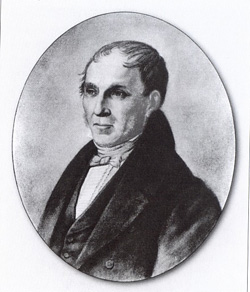
Adolf Stieler was a German geographer and cartographer born 1775 in Gotha. His main work was the Hand Atlas first issued in 1826. He died 1836 in Gotha.

Afrika
Gotha, 1828
Steel engraved map of Africa from Stieler Atlas, engraved by Joh. Carl Ausfeld.
Afrika
1828 - Adolf Stieler
10135Old coloured map of Africa. Printed in Gotha in the year 1828.
Sold
Stieler's Schul-Atlas über alle Theile der Erde nach dem neuesten Zustande, und über das...
Justus Perthes, Gotha, 1840
The Schul-Atlas also known as Kleiner Stieler was a very pobular atlas used in schools in Germany during the 19th century. It is a reduced version of A. Stieler's Hand-Atlas and was first...
Stieler's Schul-Atlas über alle Theile der Erde nach dem neuesten...
1840 - Adolf Stieler
12083School Atlas by Adolf Stieler. Printed 1840 in Gotha.
Sold

