Product successfully added to your shopping cart
There are 0 items in your cart. There is 1 item in your cart.
Wall Maps

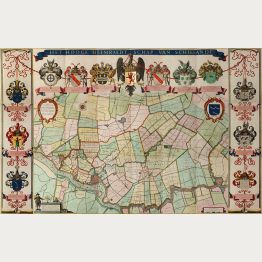
Afbeelding van de Zyp, Haer waere gelegentheit van Dyckage, Weegen, Watringen en Schey-slooten,...
Amsterdam, 1665
Magnificent Wall Map of the Zijpe- en Hazepolder in Noord-Holland.Beautiful coloured wall map of Zijpe in the Dutch province of Noord-Holland by Jan Dirksz Zoutman. Consists of a total of 6...
Afbeelding van de Zyp, Haer waere gelegentheit van Dyckage, Weegen,...
1665 - Jan Dirksz Zoutman
11714Rare and very decorative wall map of Zijpe in Noord-Holland by J. C. Zoutman. Printed in 1665 in Amsterdam.
1 950,00 €![Ughi, Italy, Venezia, Venice, 1729 [1739]: Iconografica Rappresentatione della Inclita Città di Venezia Consacrata al Reggio Serenissimo Domino Veneto]( "Lodovico Ughi: Iconografica Rappresentatione della Inclita Città di Venezia Consacrata al Reggio Serenissimo Domino Veneto")
Iconografica Rappresentatione della Inclita Città di Venezia Consacrata al Reggio Serenissimo...
Lodovico Furlanetto, Venice, 1729 [1739]
Ughi's Important and Rare Wall Map of Venice.Lodovico Ughi, the author or dedicator of the map, remains a rather elusive historical figure, with limited information available about his life...
Iconografica Rappresentatione della Inclita Città di Venezia Consacrata...
1729 - Lodovico Ughi
12789Antique map of Venice, Venezia. Printed in Venice by Lodovico Furlanetto in 1739.
28 000,00 €
Nieuwe kaart van den lande van Utrecht ... doen meten, en in kaart brengen, door Bernard du Roy ...
J. Covens & C. Mortier, Amsterdam, 1743
Magnificent Wall Map of the Province of Utrecht.Old coloured map of the province of Utrecht by Bernard de Roy. Consists of a total of 15 segments, of which 10 are double-sheet engraved maps...
Nieuwe kaart van den lande van Utrecht ... doen meten, en in kaart...
1743 - Bernard de Roy
11713Rare, well preserved wall map of the province Utrecht by B. de Roy. Printed in 1743 by Covens and Mortier.
5 900,00 €
Map of the Shooting Districts lying between Hangchow - Nanking - Wuhu and Shanghai compiled from...
Shanghai, 1909
A Large and Very Detailed Map of the Shanghai Region.This expansive and detailed map of Shanghai and its surroundings was created with a unique purpose - assisting a gentleman in finding...
Map of the Shooting Districts lying between Hangchow - Nanking - Wuhu...
1909 - Fred & Helen Mann
12835Large antique folding map of the Shanghai region. Printed in Shanghai in 1909.
3 500,00 €
Het Hooge Heemraedt Schap van Schielandt
Johan Vingbooms, Amsterdam, 1660
The exceptional rare first edition of Stampioen's Schieland wall map in stunning original colour and perfect condition.Original old hand-coloured engraved wall-map of Schieland on 9...
Het Hooge Heemraedt Schap van Schielandt
1660 - Jan Janszoon Stampioen
11164Old coloured wallmap of Schieland on 15 sheets. Published by Johan Vingbooms in Amsterdam during the year 1660. First edition.
Sold

![Ughi, Italy, Venezia, Venice, 1729 [1739]: Iconografica Rappresentatione della Inclita Città di Venezia Consacrata al Reggio Serenissimo Domino Veneto](https://www.vintage-maps.com/4290-home_default/ughi-italy-venezia-venice-1729-1739.jpg "Lodovico Ughi: Iconografica Rappresentatione della Inclita Città di Venezia Consacrata al Reggio Serenissimo Domino Veneto")


