Product successfully added to your shopping cart
There are 0 items in your cart. There is 1 item in your cart.
Nieuwe kaart van den lande van Utrecht ... doen meten, en in kaart brengen, door...
Bernard de Roy (*1638 - †1707)Reference 11713
Description
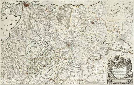
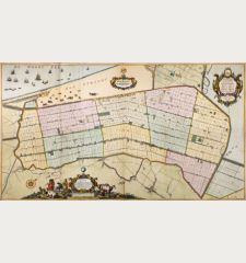
Magnificent Wall Map of the Province of Utrecht.
Old coloured map of the province of Utrecht by Bernard de Roy. Consists of a total of 15 segments, of which 10 are double-sheet engraved maps (plate size 55 x 37 cm each) and 5 smaller segments on one double-sheet (9 x 37 cm each). Constituting a wall map with a total plate size of approximately 120 x 185 cm. The individual leaves are bound contemporary in a large half sheepskin (55 x 35,5 cm, Imperial folio) with marbled paper over the covers. A handwritten title Kaart van het Land van Utrech door B. du Roy decorates the front cover.
The first image above was compiled with the help of image processing to obtain an overall impression of the large wall map. The single sheets of the map are bound in style of an atlas.
The rare wall map shows Utrecht in the centre, Amsterdam with the Haarlemmermeer in the northwest. In the north Naarden at the Zuiderzee (now Gooimeer) up to Schoonhoven, Nieuwpoort, Leerdam, Asperen and Heukelum in the south. It shows cities, villages and settlements and the differentiation of the land ownerships. The boundaries of the polders of the entire region with the designation of the owners are presented. Also depicted are drainage canals, windmills, landscape areas, ornamental gardens, as well as larger buildings and churches.
The first edition from a total of four editions, was published by Nicolas Visscher in 1696. This copy is the second, revised edition, prepared by J. Coven and C. Mortier in 1743. The plates have been engraved by T. Doesburgh.
The large Dutch wall maps are rare because most of the copies were used in their actual purpose to decorate the walls of the houses of the wealthy citizens. Those examples have not been preserved in most cases. Bounded and protected in a cover, our copy has lasted the years.
Details
| Cartographer | Bernard de Roy |
| Title | Nieuwe kaart van den lande van Utrecht ... doen meten, en in kaart brengen, door Bernard du Roy ... |
| Publisher, Year | J. Covens & C. Mortier, Amsterdam, 1743 |
| Plate Size | 120.0 x 185.0 cm (47.2 x 72.8 inches) |
| Cover | Half leather binding |
Condition
Cartographer
Images to Download
If you like to download the image of this map with a resolution of 1200 pixels, please follow the link below.
You can use this image for publication on your personal or commercial websites for free if you set a link to this website. If you need photographs with a higher resolution, please contact us.
Netherlands - Roy, Bernard de - Nieuwe kaart van den lande van Utrecht ......

![[Aa-Berlicum-Erp] [Aa-Berlicum-Erp]](https://www.vintage-maps.com/2588-home_default/anonymous-netherlands-river-aa-1780.jpg)
![[Kleve, Duisburg, Emmerich, Gennep] Cliviam, Ducatus Clivensis - Duisburgum - Embrica, Clivensis ditionis - Gennapium... [Kleve, Duisburg, Emmerich, Gennep] Cliviam, Ducatus Clivensis - Duisburgum - Embrica, Clivensis ditionis - Gennapium...](https://www.vintage-maps.com/3818-home_default/braun-hogenberg-north-rhine-westphalia-emmerich-duisburg-kleve.jpg)
