Product successfully added to your shopping cart
There are 0 items in your cart. There is 1 item in your cart.
Total products

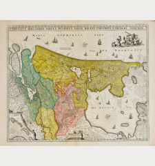
Provinces Unies des Pays-Bas / Belgium Foederatum
Alexis Hubert Jaillot (*1632 - †1712)Old coloured map of the Netherlands. Printed in Amsterdam by P. Mortier circa 1730.
Reference 12526
Description
Antique map of the Netherlands by H. Jaillot at P. Mortier. Shows the Netherlands with sea battles and sunk ships on the North Sea. To the top left a title cartouche.
Details
| Cartographer | Alexis Hubert Jaillot |
| Title | Provinces Unies des Pays-Bas / Belgium Foederatum |
| Publisher, Year | P. Mortier, Amsterdam, circa 1730 |
| Plate Size | 47.5 x 61.6 cm (18.7 x 24.3 inches) |
| Sheet Size | 53.0 x 63.0 cm (20.9 x 24.8 inches) |
Condition
A few small ink spots and slightly stained in the upper area. Very good condition with old outline colour. Never framed before.
Cartographer
Hubert Jaillot, one of the most important French cartographers of the 17th century, was born 1632. He had a partnership with Nicolas Sanson's son and re-published and re-engraved many Sanson maps. The Atlases and map mainly have been printed by Pierre Mortier in Amsterdam but also in Paris. He died 1712 in Paris.
Images to Download
If you like to download the image of this map with a resolution of 1200 pixels, please follow the link below.
You can use this image for publication on your personal or commercial websites for free if you set a link to this website. If you need photographs with a higher resolution, please contact us.
Alexis Hubert Jaillot: Provinces Unies des Pays-Bas / Belgium Foederatum.
Old coloured map of the Netherlands. Printed in Amsterdam by P. Mortier circa 1730.
Netherlands - Jaillot, Alexis Hubert - Provinces Unies des Pays-Bas / Belgium...

![[Aa-Berlicum-Erp] [Aa-Berlicum-Erp]](https://www.vintage-maps.com/2588-home_default/anonymous-netherlands-river-aa-1780.jpg)
![[Kleve, Duisburg, Emmerich, Gennep] Cliviam, Ducatus Clivensis - Duisburgum - Embrica, Clivensis ditionis - Gennapium... [Kleve, Duisburg, Emmerich, Gennep] Cliviam, Ducatus Clivensis - Duisburgum - Embrica, Clivensis ditionis - Gennapium...](https://www.vintage-maps.com/3818-home_default/braun-hogenberg-north-rhine-westphalia-emmerich-duisburg-kleve.jpg)
