Product successfully added to your shopping cart
There are 0 items in your cart. There is 1 item in your cart.
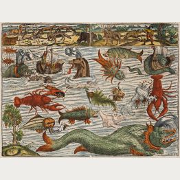
Sea Monsters
![Fries, North Africa, 1525: [Tab. Mo. Primae Partis Aphricae et Tabula Secunde partis Aphricae.]]( "Laurent Fries: [Tab. Mo. Primae Partis Aphricae et Tabula Secunde partis Aphricae.]")
[Tab. Mo. Primae Partis Aphricae et Tabula Secunde partis Aphricae.]
Johannes Grüninger, Strasbourg, 1525
Early woodcut map of North Africa by Laurent Fries after Martin Waldseemüller. Shows the the northern and western part of the continent. This woodcut map comes from the 1525 Strasbourg edition of...
[Tab. Mo. Primae Partis Aphricae et Tabula Secunde partis Aphricae.]
1525 - Laurent Fries
11887Antique woodcut map of North Africa. Printed in Strasbourg by Johannes Grüninger in 1525.
1 500,00 €![Münster, Asian Continent, 1540 [1578]: Die Länder Asie nach ihrer gelegenheit bisz in Indiam werden in dieser Tafeln verzeichnet]( "Sebastian Münster: Die Länder Asie nach ihrer gelegenheit bisz in Indiam werden in dieser Tafeln verzeichnet")
Die Länder Asie nach ihrer gelegenheit bisz in Indiam werden in dieser Tafeln verzeichnet
Heinrich Petri, Basle, 1540 [1578]
The earliest printed map of the Asian Continent. Asia is shown from the Caspian Sea to the Pacific Ocean. In Southeast Asia the islands Java Major and Minor are named, also Borneo and the Moluccas...
Die Länder Asie nach ihrer gelegenheit bisz in Indiam werden in dieser...
1540 - Sebastian Münster
12841Coloured woodcut map of the Asian continent. Printed in Basle by Heinrich Petri in 1578.
1 800,00 €
Von den Inseln
Heinrich Petri, Basle, 1550
Early woodcut map of the Greek islands of Delos, Rhodes, Alone, Thera, Sicilia and Therasia. With two sailing ships and several sea monsters. From the German edition of Sebastian Münster's...
Von den Inseln
1550 - Sebastian Münster
12588Antique woodcut map of Greece. Printed in Basle by Heinrich Petri in 1550.
150,00 €
Die Tafel gibt ein kleine anzeigung... / Von Jerusalem...
Heinrich Petri, Basle, 1550
Early woodcut map of the Holy Land with Cyprus. On the full page. From the German edition of Sebastian Münster's Cosmography, titled Cosmographey oder beschreibung aller Länder , published 1550 by...
Die Tafel gibt ein kleine anzeigung... / Von Jerusalem...
1550 - Sebastian Münster
12599Antique woodcut map of Cyprus, Israel. Printed in Basle by Heinrich Petri in 1550.
290,00 €![Münster, World Map, 1550 [1578]: Das Erst General, inhaltend die beschreibung und den Circkel des gantzen Erdtrichs und Möre]( "Sebastian Münster: Das Erst General, inhaltend die beschreibung und den Circkel des gantzen Erdtrichs und Möre")
Das Erst General, inhaltend die beschreibung und den Circkel des gantzen Erdtrichs und Möre
Heinrich Petri, Basle, 1550 [1578]
16th Century Woodcut Map of the World.Early woodcut world map by Sebastian Münster. This 'modern' map of the world is an oval projection with a vigorous surround of clouds and lusty...
Das Erst General, inhaltend die beschreibung und den Circkel des gantzen...
1550 - Sebastian Münster
1283816th century woodcut map of the world. Printed in Basle by Heinrich Petri in 1578.
3 200,00 €![Ramusio, West Africa, 1556 [1565]: Parte de l'Africa]( "Giovanni Battista Ramusio: Parte de l'Africa")
Parte de l'Africa
Tommaso Giuntis, Venice, 1556 [1565]
Early woodcut map of Western Africa by G. B. Ramusio after Giacomo Gastaldi. First published in 1556, it is one of the earliest maps of Africa grounded substantially in contemporaneous information....
Parte de l'Africa
1556 - Giovanni Battista Ramusio
12921Antique woodcut map of West Africa. Printed in Venice by Tommaso Giuntis in 1565.
980,00 €
Hispaniae descriptio - Hispania, que & Iberia in ulteriore dividit ac citeriorem...
Domenico Zenoi, Venice, 1560
The Rare and Important Zenoi Map of the Iberian Peninsula 1560.A very fine, rare and important map of Spain and Portugal by Domenico Zenoi (Zenoni). Richly decorated and engraved in 1560. In...
Hispaniae descriptio - Hispania, que & Iberia in ulteriore dividit ac...
1560 - Domenico Zenoi
12660Rare and important map of Spain and Portugal. Printed 1560 in Venice by Domenico Zenoi.
16 000,00 €
Spagnuola - Spagnvola - Descrittione dell' Isola Spagnuola prima Isola scoperta dal Colombo
Simon Galignani, Girolamo Porro, Venice, 1572
First edition of Porcacchi's very attractive and early map of Hispaniola. This finely-executed map shows the Caribbean island of Hispaniola, the second largest island of the Greater Antilles, where...
Spagnuola - Spagnvola - Descrittione dell' Isola Spagnuola prima Isola...
1572 - Tomaso Porcacchi
12363Antique map of Haiti, Hispaniola. Printed in Venice by Simon Galignani, Girolamo Porro in 1572.
280,00 €
S. Lorenzo - Descrittione dell'Isola di S. Lorenzo.
Simon Galignani, Girolamo Porro, Venice, 1572
First edition of Porcacchi's very attractive and early map of Madagascar. This finely-executed map shows the island of Madagascar in the Indian Ocean with north to the left. With a compass rose, a...
S. Lorenzo - Descrittione dell'Isola di S. Lorenzo.
1572 - Tomaso Porcacchi
12365Antique map of Madagascar, S. Lorenzo. Printed in Venice by Simon Galignani, Girolamo Porro in 1572.
250,00 €
Corfu - Descrittione dell'Isola di Corfu.
Simon Galignani, Girolamo Porro, Venice, 1572
First edition of Porcacchi's very attractive and early map of Corfu. This finely-executed map shows the Mediterranean island of Corfu oriented to the northeast. With a compass rose, a sailing ship,...
Corfu - Descrittione dell'Isola di Corfu.
1572 - Tomaso Porcacchi
12374Antique map of Corfu. Printed in Venice by Simon Galignani, Girolamo Porro in 1572.
290,00 €
Candia - Descrittione dell'Isola di Candia.
Simon Galignani, Girolamo Porro, Venice, 1572
First edition of Porcacchi's very attractive and early map of Crete. This finely-executed map shows the Mediterranean island of Crete oriented to the north. With a compass rose, sailing ships, a...
Candia - Descrittione dell'Isola di Candia.
1572 - Tomaso Porcacchi
12375Antique map of Crete. Printed in Venice by Simon Galignani, Girolamo Porro in 1572.
250,00 €
Negroponte - Descrittione dell'Isola di Negroponte.
Simon Galignani, Girolamo Porro, Venice, 1572
First edition of Porcacchi's very attractive and early map of Euboea (Negroponte). This finely-executed map shows the island of Euboea (Εύβοια) and the southeast of Greece with Athens, Chalcis and...
Negroponte - Descrittione dell'Isola di Negroponte.
1572 - Tomaso Porcacchi
12378Antique map of Euboea, Negroponte. Printed in Venice by Simon Galignani, Girolamo Porro in 1572.
220,00 €
Elba - Descrittione dell'Isola dell'Elba.
Simon Galignani, Girolamo Porro, Venice, 1572
First edition of Porcacchi's very attractive and early map of Elba. This finely-executed map shows the Mediterranean island of Elba oriented to the north. With a compass rose, sailing ships, a...
Elba - Descrittione dell'Isola dell'Elba.
1572 - Tomaso Porcacchi
12380Antique map of Elba. Printed in Venice by Simon Galignani, Girolamo Porro in 1572.
220,00 €
Inghilterra - Descrittione dell'Isola d'Inghilterra.
Simon Galignani, Girolamo Porro, Venice, 1572
First edition of Porcacchi's very attractive and early map of the British Isles. This finely-executed map shows England, Wales, Scotland and Ireland oriented with west on top. With a compass rose,...
Inghilterra - Descrittione dell'Isola d'Inghilterra.
1572 - Tomaso Porcacchi
12382Antique map of the British Isles. Printed in Venice by Simon Galignani, Girolamo Porro in 1572.
260,00 €
Sardegna - Descrittione dell'Isola di Sardigna.
Simon Galignani, Girolamo Porro, Venice, 1572
First edition of Porcacchi's very attractive and early map of Sardinia (Sardegna). This finely-executed map shows the Mediterranean island of Sardinia oriented to the west. With a compass rose, a...
Sardegna - Descrittione dell'Isola di Sardigna.
1572 - Tomaso Porcacchi
12385Antique map of Sardinia, Sardegna. Printed in Venice by Simon Galignani, Girolamo Porro in 1572.
280,00 €
Corsica - Descrittione dell'Isola di Corsica.
Simon Galignani, Girolamo Porro, Venice, 1572
First edition of Porcacchi's very attractive and early map of Corsica (Corse). This finely-executed map shows the Mediterranean island of Corsica oriented to the west. With a compass rose, a...
Corsica - Descrittione dell'Isola di Corsica.
1572 - Tomaso Porcacchi
12387Antique map of Corsica, Corse. Printed in Venice by Simon Galignani, Girolamo Porro in 1572.
320,00 €
Rhodi - Descrittione dell'Isola di Rhodi.
Simon Galignani, Girolamo Porro, Venice, 1572
First edition of Porcacchi's very attractive and early map of Rhodes (Ρόδος). This finely-executed map shows the Mediterranean island of Rhodes oriented to the west. With a compass rose, a...
Rhodi - Descrittione dell'Isola di Rhodi.
1572 - Tomaso Porcacchi
12388Antique map of Rhodes. Printed in Venice by Simon Galignani, Girolamo Porro in 1572.
220,00 €
Typus Orbis Terrarum, Americae sive Novi Orbis, Nova Descriptio, Africae Tabula Nova, Asiae Nova...
Gielis Coppens van Diest, Christoffel Plantin, Antwerp, 1573-1584
Ortelius' World and Continents from the First Modern Atlas.A fine set consisting of a world map and four of the continents from the first modern atlas Theatrum Orbis Terrarum by Abraham...
Typus Orbis Terrarum, Americae sive Novi Orbis, Nova Descriptio, Africae...
1573 - Abraham Ortelius
12683Old coloured world map and continent maps by Abraham Ortelius. Published in 1573-84 in Antwerp.
18 000,00 €![Münster, Greece, 1574: [Griechenland nach seinen Land-Schafften und eigenschafften.]]( "Sebastian Münster: [Griechenland nach seinen Land-Schafften und eigenschafften.]")
[Griechenland nach seinen Land-Schafften und eigenschafften.]
Heinrich Petri, Basle, 1574
Early, attractive woodcut map of Greece. From the German edition of Sebastian Münster's Cosmography, titled Cosmographey oder beschreibung aller Länder , published 1574 by Heinrich Petri in Basel.
[Griechenland nach seinen Land-Schafften und eigenschafften.]
1574 - Sebastian Münster
11316Antique woodcut map of Greece. Printed in Basle by Heinrich Petri in 1574.
200,00 €![Münster, Holy Land, Israel, Cyprus, 1574: [Die Tafel gibt ein klein anzeigung...]]( "Sebastian Münster: [Die Tafel gibt ein klein anzeigung...]")
[Die Tafel gibt ein klein anzeigung...]
Heinrich Petri, Basle, 1574
Early, attractive woodcut map of the Holy Land with Cyprus. On the full page. From the German edition of Sebastian Münster's Cosmography, titled Cosmographey oder beschreibung aller Länder ,...
[Die Tafel gibt ein klein anzeigung...]
1574 - Sebastian Münster
11319Antique woodcut map of Cyprus, Israel. Printed in Basle by Heinrich Petri in 1574.
290,00 €
Von der Insel Corsica
Heinrich Petri, Basle, 1574
Small, early woodcut map of Corsica by Sebastian Münster. On the full text sheet. From the German edition of Sebastian Münster's Cosmography, titled Cosmographey oder beschreibung aller Länder ,...
Von der Insel Corsica
1574 - Sebastian Münster
11387Antique woodcut map of Corse, Corsica. Printed in Basle by Heinrich Petri in 1574.
190,00 €
Negroponte
Nicolas Chesneau, Michel Sonnius, Paris, 1575
A very scarce early woodcut map of Euboea (Negroponte). Below and verso description of Euboea. Ruled in brown ink.The map was published in the French edition of the Cosmographia Universalis...
Negroponte
1575 - Francois de Belleforest
11315Antique woodcut map of Negroponte, Euboea. Printed in Paris by Nicolas Chesneau, Michel Sonnius in 1575.
450,00 €
Nova Descriptio Hispaniae
G. de Jode, Antwerp, 1578
This scarce map of Spain and Portugal originates from the renowned Italian architect Pirro Ligorio, as indicated at the top, and was engraved by Johannes and Lucas Doetecum for Gerard de Jode's...
Nova Descriptio Hispaniae
1578 - Gerard de Jode
12852Antique map of Spain - Portugal. Printed in Antwerp by G. de Jode in 1578.
3 500,00 €
Larii Lacus vulgo Comensis Descriptio / Territorii Romani Descrip. / Fori Iulii vulgo Friuli Typus
Antwerp, 1584
Nice original old coloured map of Lake Como (Lago di Como), Rome (Roma) and surroundings and the region of Udine in the northern part of the Adriatic Sea by Abraham Ortelius. From the 1584 Latin...
Larii Lacus vulgo Comensis Descriptio / Territorii Romani Descrip. /...
1584 - Abraham Ortelius
11351Old coloured map of Udine, Rome, Lake Como. Printed in Antwerp in the year 1584.
600,00 €
![Fries, North Africa, 1525: [Tab. Mo. Primae Partis Aphricae et Tabula Secunde partis Aphricae.]](https://www.vintage-maps.com/3651-home_default/fries-north-africa-1525.jpg "Laurent Fries: [Tab. Mo. Primae Partis Aphricae et Tabula Secunde partis Aphricae.]")
![Münster, Asian Continent, 1540 [1578]: Die Länder Asie nach ihrer gelegenheit bisz in Indiam werden in dieser Tafeln verzeichnet](https://www.vintage-maps.com/4315-home_default/muenster-asian-continent-1540-1578.jpg "Sebastian Münster: Die Länder Asie nach ihrer gelegenheit bisz in Indiam werden in dieser Tafeln verzeichnet")


![Münster, World Map, 1550 [1578]: Das Erst General, inhaltend die beschreibung und den Circkel des gantzen Erdtrichs und Möre](https://www.vintage-maps.com/4309-home_default/muenster-world-map-1550-1578.jpg "Sebastian Münster: Das Erst General, inhaltend die beschreibung und den Circkel des gantzen Erdtrichs und Möre")
![Ramusio, West Africa, 1556 [1565]: Parte de l'Africa](https://www.vintage-maps.com/4474-home_default/ramusio-west-africa-1556-1565.jpg "Giovanni Battista Ramusio: Parte de l'Africa")


![Münster, Greece, 1574: [Griechenland nach seinen Land-Schafften und eigenschafften.]](https://www.vintage-maps.com/1541-home_default/muenster-greece-1574.jpg "Sebastian Münster: [Griechenland nach seinen Land-Schafften und eigenschafften.]")
![Münster, Holy Land, Israel, Cyprus, 1574: [Die Tafel gibt ein klein anzeigung...]](https://www.vintage-maps.com/1544-home_default/muenster-holy-land-israel-cyprus-1574.jpg "Sebastian Münster: [Die Tafel gibt ein klein anzeigung...]")


