Product successfully added to your shopping cart
There are 0 items in your cart. There is 1 item in your cart.
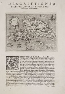
Spagnuola - Spagnvola - Descrittione dell' Isola Spagnuola prima Isola scoperta dal...
Tomaso Porcacchi (*1530 - †1585)Reference 12363
Description
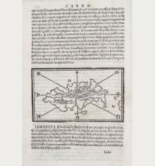
First edition of Porcacchi's very attractive and early map of Hispaniola. This finely-executed map shows the Caribbean island of Hispaniola, the second largest island of the Greater Antilles, where the states of Haiti and Dominican Republic are located. With two sailing ships, compass rose, title cartouche, a mermaid and several sea monsters. Very skillfully engraved by Girolamo Porro.
From the rare first edition of the famous L'Isole piu famose del Mondo the Isolario or Book of Islands by the Italian humanist and scholar Tomaso Porcacchi. Published 1572 in Venezia in a collaboration with the bookseller Simone Galignani and the Paduan engraver Girolamo Porro. A second edition followed in 1576, and further editions posthumously in 1590, 1604, 1605, 1620, 1686 and 1713.
Details
| Cartographer | Tomaso Porcacchi |
| Title | Spagnuola - Spagnvola - Descrittione dell' Isola Spagnuola prima Isola scoperta dal Colombo |
| Publisher, Year | Simon Galignani, Girolamo Porro, Venice, 1572 |
| Plate Size | 10.5 x 14.2 cm (4.1 x 5.6 inches) |
| Sheet Size | 29.5 x 20.0 cm (11.6 x 7.9 inches) |
Condition
Cartographer
Images to Download
If you like to download the image of this map with a resolution of 1200 pixels, please follow the link below.
You can use this image for publication on your personal or commercial websites for free if you set a link to this website. If you need photographs with a higher resolution, please contact us.
Central America - Caribbean - Porcacchi, Tomaso - Spagnuola - Spagnvola - Descrittione dell'...

![[West Indies, Jamaica, Hispaniola and South America] [West Indies, Jamaica, Hispaniola and South America]](https://www.vintage-maps.com/3035-home_default/bordone-central-america-caribbean-jamaica-hispaniola.jpg)
![[Lesser Antilles, West Indies] Guadalupe, Dominica, Matinina [Lesser Antilles, West Indies] Guadalupe, Dominica, Matinina](https://www.vintage-maps.com/3027-home_default/bordone-central-america-caribbean-guadeloupe-martinique.jpg)
