Product successfully added to your shopping cart
There are 0 items in your cart. There is 1 item in your cart.
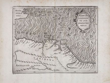
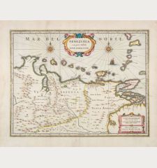
Residuum Continentis Cum Adiacentibus Insulis.
Cornelius Wytfliet (*1550 - †1597)Reference 11884
Description
Early and important antique map of Venezuela and the eastern part of the Caribbean by Cornelis van Wytfliet. First published in 1597 in Descriptionis Ptolemaicae Augmentum. Showing the north coast of South America, Venezuela with parts of the Dominican Republic, Puerto Rico and the Lesser Antilles to Trinidad and Tobago. Top right a title cartouche.
P. D. Burden about Wytfliet's America-Atlas :
In 1597 Cornelis van Wytfliet published his Augmentum to Ptolemy's Geography. This is true in as much as it covers all the Americas, a part of the world unknown to the latter; however, no other connection between them exists. Dedicated to Philip III of Spain it is a history of the New World to date, recording its discovery, natural history etc. For the book Wytfliet had engraved nineteen maps, by whom we do not know, one of the world and eighteen regional maps of the Americas. . . As such this book can be truly called the first atlas of America. It was an immediate success and ran to several editions.
Details
| Cartographer | Cornelius Wytfliet |
| Title | Residuum Continentis Cum Adiacentibus Insulis. |
| Publisher, Year | Louvain, circa 1597 |
| Plate Size | 22.8 x 29.1 cm (9.0 x 11.5 inches) |
| Sheet Size | 29.4 x 38.6 cm (11.6 x 15.2 inches) |
Condition
Cartographer
Images to Download
If you like to download the image of this map with a resolution of 1200 pixels, please follow the link below.
You can use this image for publication on your personal or commercial websites for free if you set a link to this website. If you need photographs with a higher resolution, please contact us.
Central America - Caribbean - Wytfliet, Cornelius - Residuum Continentis Cum Adiacentibus...

![[West Indies, Jamaica, Hispaniola and South America] [West Indies, Jamaica, Hispaniola and South America]](https://www.vintage-maps.com/3035-home_default/bordone-central-america-caribbean-jamaica-hispaniola.jpg)
![[Lesser Antilles, West Indies] Guadalupe, Dominica, Matinina [Lesser Antilles, West Indies] Guadalupe, Dominica, Matinina](https://www.vintage-maps.com/3027-home_default/bordone-central-america-caribbean-guadeloupe-martinique.jpg)
