Product successfully added to your shopping cart
There are 0 items in your cart. There is 1 item in your cart.
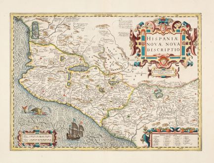
Hispaniae Novae Nova Descriptio
Jodocus Hondius (*1563 - †1612)Reference 12867
Description
Beautifully coloured antique map of Mexico by the Jodocus Hondius. With a beautiful title cartouche and mileage scales in both Dutch and Spanish miles.
The map is densely populated with towns and cities, many of which are marked with numbers or letters, especially in the Pacific region. Around Mexico City, 26 locations are detailed in the lower right cartouche. Mexico City itself is depicted on the shores of a sizable lake.
The ocean, which features Hondius' characteristic silk wave engravings, labeled as Sinus Mexicanus and decorated with a compass rose, a sailing ship flying the Spanish flag and a sea monster.
In the map's center, tiny diamonds signify Spanish encampments. The northern areas remain relatively unexplored, with the upper left mountains noted for cannibals (Anthropophagi) and people living without clothing. The mountains in the upper center are rumored to be rich in silver, while pearl fishing is highlighted on the Pacific coast. Salt lakes, known for producing the finest salt through evaporation, and the cultivation of sugar cane are notable features of this historically significant map.
Hondius drew inspiration from Abraham Ortelius' 1579 map, though the original cartographic sources remain uncertain. From the French edition of the Mercator-Hondius Atlas printed in 1633.
Details
| Cartographer | Jodocus Hondius |
| Title | Hispaniae Novae Nova Descriptio |
| Publisher, Year | H. Hondius, Amsterdam, 1633 |
| Plate Size | 34.9 x 48.2 cm (13.7 x 19.0 inches) |
| Sheet Size | 48.0 x 56.8 cm (18.9 x 22.4 inches) |
| Reference | Van der Krogt, P.: Koeman's Atlantes Neerlandici, 9510:1.1 |
Condition
Cartographer
Images to Download
If you like to download the image of this map with a resolution of 1200 pixels, please follow the link below.
You can use this image for publication on your personal or commercial websites for free if you set a link to this website. If you need photographs with a higher resolution, please contact us.
North America - Hondius, Jodocus - Hispaniae Novae Nova Descriptio

