Product successfully added to your shopping cart
There are 0 items in your cart. There is 1 item in your cart.

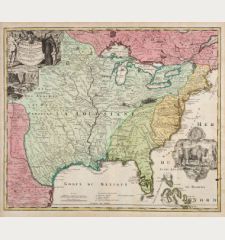
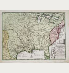
Carte De La Louisiane et du Cours du Mississipi
Covens and MortierReference 12434
Description
Beautiful old coloured example of Covens & Mortier's edition of Guillaume De L'Isle important map of the Mississippi Valley with the Great Lakes, the most significant map of this area published in the 18th century.
.De l'Isle's map was seminal in the history of mapping North America. The depiction of the Mississippi Valley was greatly improved over earlier maps, with Texas mentioned for the first time in the first state and New Orleans named for the first time in the second state of the plate. References to the expeditions of Hernando de Soto, René Robert Cavelier, and Alphonse de Tonty are also mentioned for the first time. Included are locations of various Indian tribes and French forts.
Covens & Mortier used the second state of the De l'Isle map as a template. Above the title line, below right a detailed map of the Mississippi River Delta and Mobile Bay.
Details
| Cartographer | Covens and Mortier |
| Title | Carte De La Louisiane et du Cours du Mississipi |
| Publisher, Year | Covens & Mortier, Amsterdam, circa 1730 |
| Plate Size | 45.0 x 60.0 cm (17.7 x 23.6 inches) |
| Sheet Size | 53.0 x 63.5 cm (20.9 x 25.0 inches) |
| Reference | Cumming, W.P.: The Southeast in Early Maps, No. 208; Tooley, R.V.: The Mapping of America, p. 22. |
Condition
Cartographer
Images to Download
If you like to download the image of this map with a resolution of 1200 pixels, please follow the link below.
You can use this image for publication on your personal or commercial websites for free if you set a link to this website. If you need photographs with a higher resolution, please contact us.
North America - Covens and Mortier - Carte De La Louisiane et du Cours du...

