Product successfully added to your shopping cart
There are 0 items in your cart. There is 1 item in your cart.
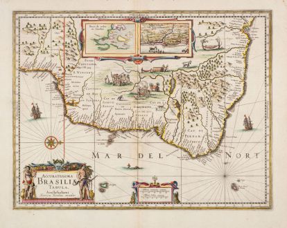
Accuratissima Brasiliae Tabula. Amstelodami Henricus Hondius excudit.
Jodocus Hondius (*1563 - †1612)Reference 11918
Description
Antique map of Brazil by Henricus Hondius. Shows a very detailed and accurate coastline while the interior is still speculative. With two inset maps of Baya de Todos os Sanctos (Bay of All Saints) and Villa d'Olinda de Pernambuco (Olinda). Decorated with scenes of natives and animals, three beautiful cartouches, sailing ships and a sea monster.
First published in the Mercator-Hondius Atlas Atlas sive Cosmographicae Meditationes de Fabrica Mundi et fabricati figura of 1630. This copy comes from the rare English edition of 1636. English text on verso.
Details
| Cartographer | Jodocus Hondius |
| Title | Accuratissima Brasiliae Tabula. Amstelodami Henricus Hondius excudit. |
| Publisher, Year | Henricus Hondius, Amsterdam, 1636 |
| Plate Size | 37.8 x 49.2 cm (14.9 x 19.4 inches) |
| Sheet Size | 48.0 x 56.5 cm (18.9 x 22.2 inches) |
| Reference | Van der Krogt, P.: Koeman's Atlantes Neerlandici, 9850:1.1 |
Condition
Cartographer
Images to Download
If you like to download the image of this map with a resolution of 1200 pixels, please follow the link below.
You can use this image for publication on your personal or commercial websites for free if you set a link to this website. If you need photographs with a higher resolution, please contact us.
South America - Hondius, Jodocus - Accuratissima Brasiliae Tabula....

![[West Indies, Jamaica, Hispaniola and South America] [West Indies, Jamaica, Hispaniola and South America]](https://www.vintage-maps.com/3035-home_default/bordone-central-america-caribbean-jamaica-hispaniola.jpg)
