Product successfully added to your shopping cart
There are 0 items in your cart. There is 1 item in your cart.
Reference 12892
Description
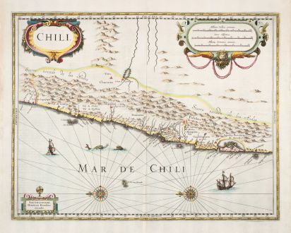
Beautiful antique map of Chile by Jodocus Hondius. Showing Chile along its Pacific coast with an eastward orientation. The rugged, mountainous terrain dominates the interior, also two fire-breathing volcanoes are shown. The sharp peaks illustrate the challenging landscape of the area. From Copiapo in the north to Castro in the south, with the city of Conception in the center.
Decorated with two sailing ships, sea monsters, three cartouches and two beautiful compass roses. From the French edition of the Mercator-Hondius Atlas printed in 1633.
Details
| Cartographer | Jodocus Hondius |
| Title | Chili |
| Publisher, Year | J. Janssonius, Amsterdam, 1633 |
| Plate Size | 37.2 x 47.7 cm (14.6 x 18.8 inches) |
| Sheet Size | 47.2 x 55.0 cm (18.6 x 21.7 inches) |
| Reference | Van der Krogt, P.: Koeman's Atlantes Neerlandici, 9920:1. |
Condition
Cartographer
Images to Download
If you like to download the image of this map with a resolution of 1200 pixels, please follow the link below.
You can use this image for publication on your personal or commercial websites for free if you set a link to this website. If you need photographs with a higher resolution, please contact us.

![[West Indies, Jamaica, Hispaniola and South America] [West Indies, Jamaica, Hispaniola and South America]](https://www.vintage-maps.com/3035-home_default/bordone-central-america-caribbean-jamaica-hispaniola.jpg)
