Product successfully added to your shopping cart
There are 0 items in your cart. There is 1 item in your cart.
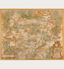
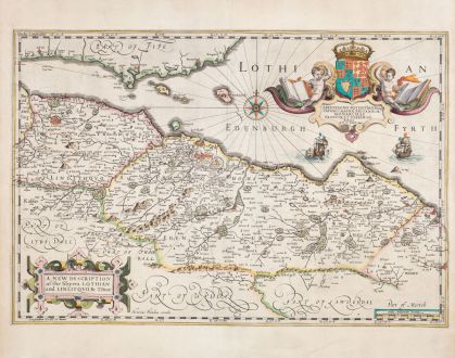
A New Description of the Shyres Lothian and Linlitquo. Be T. Pont.
Jodocus Hondius (*1563 - †1612)Reference 12817
Description
A beautiful map of the shires of Lothian in Scotland by Henricus Hondius after Timothy Pont. This map offers a splendid and detailed depiction of Lothian, providing a wealth of information about the region's prominent landmarks. It features intricate, miniature sketches of key sites, including the city of Edinburgh, Linlithgow Palace, and Tyningham House, all of which were meticulously drawn based on Timothy Pont's firsthand observations. Moreover, the map highlights several notable geographical features, including Holyrood Park, Arthur's Seat, and the Pentland Hills.
Timothy Pont, a Scottish clergyman, conducted an extensive survey of Scotland between 1595 and 1608, made that country the best mapped in the world. However, it was not until 1654 when Blaeu included these maps as Volume V in his 'Theatrum' that Pont's core work was finally published. Robert Gordon, who revisited and revised these maps for Blaeu, lamented that Pont's ambitious project remained incomplete due to the greed of printers and booksellers, preventing him from seeing it to fruition. Tragically, he passed away prematurely sometime between 1611 and 1614 at the age of 50.
The map depicting the environs of Edinburgh is a remarkable relic of Pont's work. It was the sole map engraved before his untimely demise, thanks to the financial support of the Edinburgh bookseller Andrew Hart. Jodocus Hondius in Amsterdam undertook the engraving, just prior to his own death in 1612. Although it's uncertain whether the map was published at the time, it eventually made its debut in the Mercator/Hondius atlas in 1630.
The example presented here belongs to the second state, post-1633, with the names of Jodocus Hondius and Hart removed, replaced by Henricus Hondius excudit. From the 1633 edition of the Hondius-Janssonius Atlas, French text on verso.
Details
| Cartographer | Jodocus Hondius |
| Title | A New Description of the Shyres Lothian and Linlitquo. Be T. Pont. |
| Publisher, Year | H. Hondius, Amsterdam, 1633 |
| Plate Size | 36.7 x 53.8 cm (14.4 x 21.2 inches) |
| Sheet Size | 47.5 x 56.7 cm (18.7 x 22.3 inches) |
| Reference | Van der Krogt, P.: Koeman's Atlantes Neerlandici, 5815:1.2 |
Condition
Cartographer
Images to Download
If you like to download the image of this map with a resolution of 1200 pixels, please follow the link below.
You can use this image for publication on your personal or commercial websites for free if you set a link to this website. If you need photographs with a higher resolution, please contact us.
Scotland - Hondius, Jodocus - A New Description of the Shyres Lothian...


![Scotiae Regnum [2 Maps, North and South Scotland] Scotiae Regnum [2 Maps, North and South Scotland]](https://www.vintage-maps.com/4278-home_default/mercator-british-isles-scotland-1633.jpg)
![[British Isles and England & Wales] [British Isles and England & Wales]](https://www.vintage-maps.com/2941-home_default/bordone-british-isles-england-and-wales-1528-1565.jpg)

![[The Firth of Murry] - To the Rt Hon.ble, my Lord Viscount Torbat, Lord Register of the Kingdom of Scotland [The Firth of Murry] - To the Rt Hon.ble, my Lord Viscount Torbat, Lord Register of the Kingdom of Scotland](https://www.vintage-maps.com/2244-home_default/collins-scotland-north-sea-moray-firth-inverness.jpg)
