Product successfully added to your shopping cart
There are 0 items in your cart. There is 1 item in your cart.
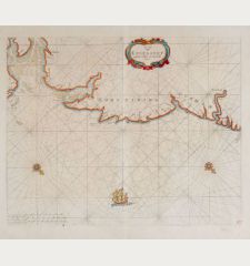
Pascaart vande Noort-Zee. Tabula Hydrographica Oceani Borealis.
Johannes Janssonius (*1588 - †1664)Reference 11914
Description
Rare and very decorative, old coloured sea chart of the North Sea by J. Janssonius. Shows the North Sea coast with the Shetland and Orkney Islands, the Scottish and English east coast, Calais and Dover, the North Sea coast of the Netherlands and Germany, the coastline of the Baltic Sea in the east to Szczecin and in the north the south coast of Sweden. With Denmark and the Atlantic coast of Norway to Trondheim. North is oriented to the right. Decorated with rhumb lines, two compass roses and a cartouche with mileage scale. The title cartouche is flanked by two navigators with a Jacob's staff and an atlas with nautical charts.
From the first real sea atlas, known as the Atlas Maritimus. This map comes from the German edition Das Fünffte Theil Des Grossen Atlantis, Welches begreiffet Die Wasser-Welt, Das ist: Eine sehr kunstreiche Abbildung und Beschreibung aller Wasser und Meeren... by Johannes Janssonius (J. Jansson), published as the fifth volume of his Atlas Novus in Amsterdam in 1650.
Details
| Cartographer | Johannes Janssonius |
| Title | Pascaart vande Noort-Zee. Tabula Hydrographica Oceani Borealis. |
| Publisher, Year | Johannes Janssonius, Amsterdam, 1650 |
| Plate Size | 43.4 x 55.1 cm (17.1 x 21.7 inches) |
| Sheet Size | 50.0 x 58.0 cm (19.7 x 22.8 inches) |
| Reference | Van der Krogt, P.: Koeman's Atlantes Neerlandici, 0200:1 |
Condition
Cartographer
Images to Download
If you like to download the image of this map with a resolution of 1200 pixels, please follow the link below.
You can use this image for publication on your personal or commercial websites for free if you set a link to this website. If you need photographs with a higher resolution, please contact us.
Atlantic Ocean - Janssonius, Johannes - Pascaart vande Noort-Zee. Tabula...


![[Manuscript Chart of the South Atlantic Ocean] Tweede stuck wassende Graedkaert van de Kaap Verdische Eilanden tot de Kaap [Manuscript Chart of the South Atlantic Ocean] Tweede stuck wassende Graedkaert van de Kaap Verdische Eilanden tot de Kaap](https://www.vintage-maps.com/3745-home_default/blaeu-manuscript-1690.jpg)

![[Canary Islands] [Canary Islands]](https://www.vintage-maps.com/3021-home_default/bordone-spain-portugal-canaries-tenerife-gran-canaria.jpg)
![[Porto Santo and Madeira] [Porto Santo and Madeira]](https://www.vintage-maps.com/3025-home_default/bordone-spain-portugal-porto-santo-madeira-1528-1565.jpg)
