Product successfully added to your shopping cart
There are 0 items in your cart. There is 1 item in your cart.
Celestial Charts

Uranometria, Omnium Asterismorum Continens Schemata, Nova Methodo Delineata, Aereis Laminis Expressa
Christoph Mang, Augsburg, 1603
First Edition of Johann Bayer's Epochal Star Atlas.This work was to uranography what the Gutenberg Bible was to printing. --George Lovi, Hungarian-American astronomical cartographer....
Uranometria, Omnium Asterismorum Continens Schemata, Nova Methodo...
1603 - Johann Bayer
12732Celestial Atlas by Johann Bayer. Printed in Augsburg in 1603.
39 000,00 €
P. Merulae Cosmographiae Partis II ... Europa & speciatim Hispania describitur.
W. Blaeu, Amsterdam, 1635
Titlepage of Cosmographiae Generalis by Paulus Merula. With a small woodcut of a terrestrial and celestial globe on a beam balance. Printed 1635 by Willem Blaeu in Amsterdam.
P. Merulae Cosmographiae Partis II ... Europa & speciatim Hispania...
1635 - Willem Janszoon Blaeu
12636Woodcut of a title page. Printed in Amsterdam by W. Blaeu in 1635.
35,00 €
Geographische Universal-Zeig und Schlag-Uhr
J.B. Homann, Nuremberg, circa 1720
Curious Depiction of California as an Island.Illustration of a geographical clock by Zacharias Landteck, who manufactured it in the early 1700's in Nuremberg. The engraving was created by J....
Geographische Universal-Zeig und Schlag-Uhr
1720 - Johann Baptist Homann
11496Old coloured map of California as an Island. Printed in Nuremberg by J.B. Homann circa 1720.
980,00 €
Introduction a la Geographie
Covens & Mortier, Amsterdam, circa 1730
Small engraved map of the western hemisphere and the northern sky on a title page by Covens and Mortier.
Introduction a la Geographie
1730 - Covens and Mortier
12619Antique map of the world. Printed in Amsterdam by Covens & Mortier circa 1730.
190,00 €
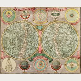
Planisphaerium coeleste
M. Seutter, Augsburg, circa 1730
Beautiful double hemisphere celestial chart of the northern and southern sky with allegorical constellations by Matthäus Seutter. The star map is surrounded by seven smaller astronomical diagrams....
Planisphaerium coeleste
1730 - George Matthäus Seutter
12980Old coloured celestial map. Printed in Augsburg by M. Seutter circa 1730.
1 500,00 €
Sphaera Armillaris / Instrumentum artificiale Orrery ab inventore appellatum
T. C. Lotter, Augsburg, 1774
Rare and very decorative engraving with two astronomical devices: On the left an armillary sphere to show the movement of the heavenly bodies, on the right a planetarium, as it was constructed in...
Sphaera Armillaris / Instrumentum artificiale Orrery ab inventore...
1774 - Tobias Conrad Lotter
12741Armillary Sphere and Planetarium. Printed in Augsburg by T. C. Lotter in 1774.
950,00 €
Von den Himeln und von den Planeten
Anton Sorg, Augsburg, 1482
Very rare and early woodcut of the celestial spheres by Konrad von Megenberg. From the incunable Buch der Natur or Book of Nature printed by Anton Sorg in Augsburg in 1482.This full-page...
Von den Himeln und von den Planeten
1482 - Konrad von Megenberg
12467Incunable woodcut view of the heavenly spheres. Printed in Augsburg by Anton Sorg in 1482.
Sold![Anonymous, Northern Sky, before 1569: [Celestial Chart - Himmelskarte]]( "Anonymous: [Celestial Chart - Himmelskarte]")
[Celestial Chart - Himmelskarte]
Vienna, before 1569
Unrecorded Star Map of the 16th Century.A large, scarce 16th century celestial chart of the northern sky. We could not locate any bibliographical information about this engraving. It is...
[Celestial Chart - Himmelskarte]
1569 - Anonymous
11694Exceptionally rare star map of the northern sky. Most likely printed in Vienna before 1569.
Sold
Haemisphaerium Scenographicum Australe Coeli Stellati et Terrae
Valk & Schenk, Amsterdam, (1660) 1708
Spectacular Star Map of the Southern Sky by Andreas Cellarius.This celestial hemisphere shows the classical constellations of the southern skies over a globe showing South America, Southern...
Haemisphaerium Scenographicum Australe Coeli Stellati et Terrae
1660 - Andreas Cellarius
11488Old coloured celestial map. Printed in Amsterdam by Valk & Schenk in 1708.
Sold
Atlas Coelestius: seu Harmonia Macrocosmica
Valk & Schenk, Amsterdam, (1660) 1708
Old coloured title page of Andreas Cellarius' star atlas Harmonia Macrocosmica Seu Atlas Universalis Et Novus first published by J. Janssonius in 1660. This title page is from the reissue by Valk...
Atlas Coelestius: seu Harmonia Macrocosmica
1660 - Andreas Cellarius
11500Copper engraving of a title page. Cellarius Harmonia Macrocosmica. Printed in Amsterdam by Valk & Schenk in 1708.
Sold Planisphere Celeste Septentrional")
Planisphere Celeste Meridionale (and) Planisphere Celeste Septentrional
Paris, 1705
Two separate charts of southern and northern Hemisphere according to Philippe de la Hire (1640-1714). Hemisphere with surround of text and engraved dedication to Jean Paul Bignon from Herman van Loon.
Planisphere Celeste Meridionale (and) Planisphere Celeste Septentrional
1705 - Nicolas de Fer
10062Coloured celestial map. Printed in Paris in the year 1705.
Sold
Tabula Selenographica in qua Lunarium Macularum
J. B. Homann, Nuremberg, circa 1730
Decorative map of the surface of the moon in two hemispheres. Surrounded by small illustrations of the lunar eclipse.
Tabula Selenographica in qua Lunarium Macularum
1730 - Johann Gabriel Doppelmayr
10300Old coloured celestial map. Printed in Nuremberg by J. B. Homann circa 1730.
Sold
Ephemerides Motuum Coelestium Geometricae
J. B. Homann, Nuremberg, 1742
Copper engraved map of the planetary motion as per observations of 1708 and 1709 by J. G. Doppelmayr. Also showing the Hooke's calculation of the distance between the Sun and Sirius. From "Atlas...
Ephemerides Motuum Coelestium Geometricae
1742 - Johann Gabriel Doppelmayr
10390Old coloured celestial map. Printed in Nuremberg by J. B. Homann in 1742.
Sold
Phaenomena in Planetis Primariis Quae facies diversas, ex illorum phasibus, maculis et fasciis...
J. B. Homann, Nuremberg, 1742
Copper engraved map of the major planets by J. G. Doppelmayr. Showing the phases of the planets (Mercury, Venus, Mars, Jupiter, Saturn) as it can be seen from the Earth, explanation of the...
Phaenomena in Planetis Primariis Quae facies diversas, ex illorum...
1742 - Johann Gabriel Doppelmayr
10391Old coloured celestial map. Printed in Nuremberg by J. B. Homann in 1742.
Sold
Theoria Planetarum Primariorum
Nuremberg, circa 1746
Hand coloured copper engraving from J.G. Doppelmaier by J.B. Homann, showing orbit of the planets.
Theoria Planetarum Primariorum
1746 - Johann Baptist Homann
10001Doppelmaier's map of the orbit of the planets. Published in Nuremberg by J. B. Homann in 1746.
Sold
The Solar System, with the Orbit of 5 remarkable Comets.
E. Bowen, London, 1747
Fascinating model of the solar system out to Saturn. Showing the orbits of 5 comets, the date the comets first appeared, the period and a prediction on the next appearance. One comet out of the...
The Solar System, with the Orbit of 5 remarkable Comets.
1747 - Emanuel Bowen
11281Engraving of the solar system with comets. Published by E. Bowen in London in 1747.
Sold
Vorstellung der in der Nacht zwischen den 8. u. 9. Aug. 1748
Nuremberg, 1748
Hand coloured copper engraving from T. Mayer by Homann Heirs, showing the lunar eclipse of August 1748. With the coloured moon and hemisphere.
Vorstellung der in der Nacht zwischen den 8. u. 9. Aug. 1748
1748 - Homann Erben
10002Old coloured map of the moon. Published in Nuremberg in 1748,
Sold
Planisphaerium Coeleste
circa 1750
A very decorative double hemisphere celestial chart. The smaller circular diagram showing the rotation of the Planets, according to Tycho Brahe, Ptolemy and Copernicus. Further decorated with...
Planisphaerium Coeleste
1750 - Tobias Conrad Lotter
10043Old coloured celestial map. Printed circa 1750.
Sold
Schematismus geographiae mathematicae
Nuremberg, 1753
Copper engraved map of the solar system after Schatz by Homann Erben. Showing the round solar system with globe, compass rose and an armillary sphere. Dated 1753.
Schematismus geographiae mathematicae
1753 - Homann Erben
10389Antique celestial map. Printed in Nuremberg in the year 1753.
Sold
Globus Terrestris ad Sphaeram Obliquam Delineatus / Globus Coelestis cum Astrodictico Artificiali...
1774
Hand colored engraving showing terrestrial and celestial globes.
Globus Terrestris ad Sphaeram Obliquam Delineatus / Globus Coelestis cum...
1774 - Tobias Conrad Lotter
10040Old coloured engraving of a pair of globes. Published in 1774.
Sold


![Anonymous, Northern Sky, before 1569: [Celestial Chart - Himmelskarte]](https://www.vintage-maps.com/2076-home_default/anonymous-northern-sky-before-1569.jpg "Anonymous: [Celestial Chart - Himmelskarte]")


 Planisphere Celeste Septentrional")


