Product successfully added to your shopping cart
There are 0 items in your cart. There is 1 item in your cart.
Total products
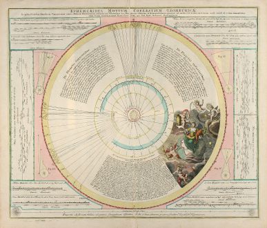
Ephemerides Motuum Coelestium Geometricae
Johann Gabriel Doppelmayr (*1671 - †1750)Old coloured celestial map. Printed in Nuremberg by J. B. Homann in 1742.
Reference 10390
Description
Copper engraved map of the planetary motion as per observations of 1708 and 1709 by J. G. Doppelmayr. Also showing the Hooke's calculation of the distance between the Sun and Sirius. From "Atlas Coelestis" published 1742 by J. B. Homann in Nuremberg.
Details
| Cartographer | Johann Gabriel Doppelmayr |
| Title | Ephemerides Motuum Coelestium Geometricae |
| Publisher, Year | J. B. Homann, Nuremberg, 1742 |
| Plate Size | 49.0 x 58.0 cm (19.3 x 22.8 inches) |
| Sheet Size | 54.0 x 62.0 cm (21.3 x 24.4 inches) |
Condition
Some creases around centrefold.
Cartographer
J. G. Doppelmayr was a Germany mathematician, cartographer and astronomer born 1671 in Nuremberg. He became Professor of Mathematics in 1704 until his death in 1750. In 1742 he completed his Atlas Coelestis together with Johann Baptist Homann. He was also member of the Royal Societies in Berlin and St. Petersburg.
Images to Download
If you like to download the image of this map with a resolution of 1200 pixels, please follow the link below.
You can use this image for publication on your personal or commercial websites for free if you set a link to this website. If you need photographs with a higher resolution, please contact us.
Johann Gabriel Doppelmayr: Ephemerides Motuum Coelestium Geometricae.
Old coloured celestial map. Printed in Nuremberg by J. B. Homann in 1742.
Celestial Charts - Doppelmayr, Johann Gabriel - Ephemerides Motuum Coelestium Geometricae

