Product successfully added to your shopping cart
There are 0 items in your cart. There is 1 item in your cart.
Antique Maps by Konrad Celtis (*1459 - †1508)
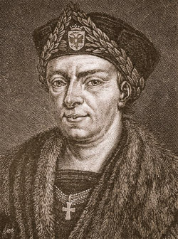
Konrad Celtis, also Conrad Celtis, born as Conrad Bickel 1459 in Wipfeld, Franconia. He was a humanistic scholar and poet of the Renaissance. He studied in Cologne, Heidelberg, Padua, Ferrara, Bologna, Florence, Venice and Rome.
Celtis was not only important as a poet, but also as a geographer and editor. He discovered the 12th century medieval copy of a late Roman road map and handed it over to his friend Konrad Peutinger around 1507. Today this copy of the ancient Roman road map is known as Tabula Peutingeriana or Peutinger's Tabula. After Peutinger's death a copy was made by a member of the family, which was published by Abraham Ortelius in 1598.
His main work is considered to be the Quattuor libri amorum, which was first published in Nuremberg in 1502. Each of the four books opens with a map drawn by Celtis himself. The woodcuts of the maps were made in the circle of Albrecht Dürer and were cut by Dürer's assistant Hans Süß von Kulmbach (Hans Suess).
Celtis died 1508 in Vienna and was buried in St. Stephen's Cathedral.

Barbara Codonea - Germaniae Latus Septentrionale
Sodalitas Celtica, Nuremberg, 1502
One of the Earliest Depictions of the Arctic Ocean. Printed in 1502.Very rare first edition of the woodcut map of Central and Northern Europe with the early depiction of the Arctic Ocean by...
Barbara Codonea - Germaniae Latus Septentrionale
1502 - Konrad Celtis
12465Early woodcut map of Northern and Central Europe. Printed in Nuremberg by Sodalitas Celtica in 1502.
7 800,00 €
