Product successfully added to your shopping cart
There are 0 items in your cart. There is 1 item in your cart.
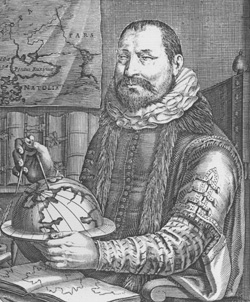
Antique Maps by Jodocus Hondius (*1563 - †1612)

Abbatia Heresfeldensis vulgo t Stifftt Hirsfeldt. Amstelodami Sumptibus Henrici Hondy
Amsterdam, circa 1620
Showing the area of Bad Hersfeld in Germany.
Abbatia Heresfeldensis vulgo t Stifftt Hirsfeldt. Amstelodami Sumptibus...
1620 - Jodocus Hondius
10014Old coloured map of Hersfeld. Printed in Amsterdam circa 1620.
150,00 €
Abbatia Heresfeldensis vulgo t Stifftt Hirsfeldt. Amstelodami Sumptibus Henrici Hondy
Amsterdam, circa 1620
Engraved map of Hesse by H. Hondius. Showing the area around Bad Hersfeld between Unter-Wegfurt and Ludwigsau at the river Fulda in Hesse. With one figural cartouche and a mileage scale. Without...
Abbatia Heresfeldensis vulgo t Stifftt Hirsfeldt. Amstelodami Sumptibus...
1620 - Jodocus Hondius
10957Antique map of Bad Hersfeld, Hesse. Printed in Amsterdam circa 1620.
180,00 €
Regni Valentiae typus
Amsterdam, 1623 or 1630
Antique map of Valencia by Jodocus Hondus. Shows the Spanish Mediterranean coast from Torrevieja to Tarragona. With Alicante, Xàbia, Dénia, Gandia, Castellón de la Plana and L'Ampolla. In the...
Regni Valentiae typus
1623 - Jodocus Hondius
12408Coloured map of Valencia. Printed in Amsterdam in 1623 or 1630.
420,00 €
China
Henricus Hondius, Amsterdam, 1623
Impressive antique map of China, Japan and Korea by Jodocus Hondius. First published in the Mercator-Hondius Atlas of 1606.At the beginning of the 17th century, little is known about this...
China
1623 - Jodocus Hondius
12412Coloured map of China. Printed in Amsterdam by Henricus Hondius in 1623.
2 200,00 €
India Orientalis
Henricus Hondius, Amsterdam, 1623
One of the Most Beautiful Early Maps of Southeast Asia.Antique map of the Indian subcontinent with the Philippines and parts of Indonesia by Jodocus Hondius. Shows Southeast Asia between...
India Orientalis
1623 - Jodocus Hondius
12649Coloured map of the Philippines, Thailand, China, India. Printed in Amsterdam by Henricus Hondius in 1623.
2 600,00 €
Gerardus Mercator natus Rupelmundae ... Iudocus Hondius natus in pago Flandriae
Henricus Hondius, Amsterdam, 1628
This double portrait depicts two renowned sixteenth-century cartographers, Gerard Mercator and Jodocus Hondius. Created shortly after Hondius' death in 1612, the engraving was made by his widow...
Gerardus Mercator natus Rupelmundae ... Iudocus Hondius natus in pago...
1628 - Jodocus Hondius
12774Copper engraving of a portrait. Mercator Hondius Double Portrait. Printed in Amsterdam by Henricus Hondius in 1628.
2 500,00 €
Iaponia
Henricus Hondius, Amsterdam, 1628
A beautiful example of Hondius' map of Japan and Korea from the early 17th century. It shows one of the greatest cartographic myth with Korea depicted as an island. But Hondius expressing his...
Iaponia
1628 - Jodocus Hondius
12778Coloured map of Japan - Korea. Printed in Amsterdam by Henricus Hondius in 1628.
2 400,00 €
China
Henricus Hondius, Amsterdam, 1628
Impressive antique map of China, Japan and Korea by Jodocus Hondius. First published in the Mercator-Hondius Atlas of 1606.At the beginning of the 17th century, little is known about this...
China
1628 - Jodocus Hondius
12779Coloured map of China. Printed in Amsterdam by Henricus Hondius in 1628.
2 700,00 €
Frisia Occidentalis Auctoribus Adriano Metio et Gerardo Freitag.
Henricus Hondius, Amsterdam, circa 1630
Engraved map of West Friesland with the islands Vlieland, Terschelling und Ameland. With 3 cartouches, two sailing ships and a compass rose. Published by H. Hondius after Adrian Metius und Gerard...
Frisia Occidentalis Auctoribus Adriano Metio et Gerardo Freitag.
1630 - Jodocus Hondius
11094Antique map of West-Friesland. Printed in Amsterdam by Henricus Hondius circa 1630.
450,00 €![Hondius, Central America - Caribbean, Bermuda, 1633 [1634]: Mappa Aestivarum Insularum, alias Barmudas Dictarum ... Accurate Descripta]( "Jodocus Hondius: Mappa Aestivarum Insularum, alias Barmudas Dictarum ... Accurate Descripta")
Mappa Aestivarum Insularum, alias Barmudas Dictarum ... Accurate Descripta
H. Hondius, Amsterdam, 1633 [1634]
Very decorative old coloured antique nautical chart of the Islands of Bermuda by Hendrick Hondius. Shows the Bermuda Islands with Grand Bermuda, Somerset Island and Saint George's Island. Decorated...
Mappa Aestivarum Insularum, alias Barmudas Dictarum ... Accurate Descripta
1633 - Jodocus Hondius
12424Old coloured sea chart of Bermuda. Printed in Amsterdam by H. Hondius in 1634.
1 700,00 €
Mappa Aestivarum Insularum, alias Barmudas Dictarum ... Accurate Descripta
H. Hondius, Amsterdam, 1633
First edition of the very decorative nautical chart of the Islands of Bermuda by Hendrick Hondius. Shows the Bermuda Islands with Grand Bermuda, Somerset Island and Saint George's Island. Decorated...
Mappa Aestivarum Insularum, alias Barmudas Dictarum ... Accurate Descripta
1633 - Jodocus Hondius
12770Coloured sea chart of Bermuda. Printed in Amsterdam by H. Hondius in 1633.
2 100,00 €
Africae nova tabula
Henricus Hondius, Amsterdam, 1633
Beautiful map of Africa by Henricus Hondius. This version of Jodocus Hondius' map depicts the continent without its decorative borders, which were removed to accommodate the atlas format. The...
Africae nova tabula
1633 - Jodocus Hondius
12776Coloured map of the African continent. Printed in Amsterdam by Henricus Hondius in 1633.
1 600,00 €
Insulae Indiae Orientalis Praecipuae, In quibus Moluccae celeberrime sunt
Henricus Hondius, Amsterdam, 1633
The Most Elegant and Decorative Map of the Region (Thomas Suarez)This map by the Dutch mapmaker Jodocus Hondius depicts the European knowledge of the East Indies, which became increasingly...
Insulae Indiae Orientalis Praecipuae, In quibus Moluccae celeberrime sunt
1633 - Jodocus Hondius
12777Coloured map of Southeast Asia. Printed in Amsterdam by Henricus Hondius in 1633.
3 600,00 €
Venezuela, cum parte Australi Novae Andalusiae.
Henricus Hondius, Amsterdam, 1633
A fine 17th century map of Venezuela and the Lesser Antilles by Jodocus Hondius. Shows Venezuela, along with the Windward Islands (comprising Dominica, Trinidad and Tobago), as well as the Lesser...
Venezuela, cum parte Australi Novae Andalusiae.
1633 - Jodocus Hondius
12790Coloured map of Venezuela. Printed in Amsterdam by Henricus Hondius in 1633.
850,00 €
Osnabrugensis Episcopatus. Autore Ioanne Gigante.
Henricus Hondius, Amsterdam, 1633
Beautiful engraved map of the Osnabrück region drawn by Joannes Gigas, published by J. Hondius. With Quakenbrück, Melle, Wittlage, Iburg, Bentlage und Lingen. One cartouche with a cityview of...
Osnabrugensis Episcopatus. Autore Ioanne Gigante.
1633 - Jodocus Hondius
12791Coloured map of Osnabrück. Printed in Amsterdam by Henricus Hondius in 1633.
450,00 €
Saxonia Inferior et Meklenborg Duc.
Henricus Hondius, Amsterdam, 1633
Early edition of the map of Northern Germany by G. Mercator. Showing the Elbe near Hamburg, Lower Saxony to Brunswick and Mecklenburg to Rügen. With Stade, Lüneburg, Lübeck, Wismar and Rostock. Top...
Saxonia Inferior et Meklenborg Duc.
1633 - Jodocus Hondius
12796Coloured map of Norddeutschland. Printed in Amsterdam by Henricus Hondius in 1633.
450,00 €
Coloniensis Archiepiscopatus
H. Hondius, Amsterdam, 1633
Beautifully coloured map of the area around Cologne by H. Hondius. Showing the Rhine between Koblenz and Wesel, with Cologne in the centre. Decorated with a title cartouche and a mileage scale....
Coloniensis Archiepiscopatus
1633 - Jodocus Hondius
12822Coloured map of Cologne. Printed in Amsterdam by H. Hondius in 1633.
370,00 €
Ducatus Holsatiae nova tabula
H. Hondius, Amsterdam, 1633
Beautiful antique map of Holstein by H. Hondius. Below the Elbe from its mouth to Hamburg. The historical landscapes are highlighted by colouring: Wagiren from the Kiel Fjord to the Bay of Lübeck,...
Ducatus Holsatiae nova tabula
1633 - Jodocus Hondius
12827Coloured map of Schleswig-Holstein, Germany. Printed in Amsterdam by H. Hondius in 1633.
490,00 €
Frisia Occidentalis Auctoribus Adriano Metio et Gerardo Freitag.
H. Hondius, Amsterdam, 1633
Beautifully coloured antique map of West Frisia with the islands of Vlieland, Terschelling and Ameland with mileage indicator and figural cartouche, two sailing ships and a compass rose. After...
Frisia Occidentalis Auctoribus Adriano Metio et Gerardo Freitag.
1633 - Jodocus Hondius
12829Coloured map of West-Friesland. Printed in Amsterdam by H. Hondius in 1633.
490,00 €
Italia nuovamente piu perfetta che mai per inanzi posta in luce.
H. Hondius, Amsterdam, 1633
Early map of Italy with rich decoration by J. Hondius. The map title is adorned with two caryatid-like women on either side. Below the ornate cartouche, the depiction of Rome's legendary founders,...
Italia nuovamente piu perfetta che mai per inanzi posta in luce.
1633 - Jodocus Hondius
12846Coloured map of Italy. Printed in Amsterdam by H. Hondius in 1633.
1 500,00 €
Portugalliae que olim Lusitania, novißima et exactißima descriptio, Auctore Vernando Alvaro Secco
H. Hondius, Amsterdam, 1633
This map of Portugal, dating back to the 17th century, is considered a notable example of cartographic craftsmanship from that period. Engraved by Baptista van Doetecum for the Mercator-Hondius...
Portugalliae que olim Lusitania, novißima et exactißima descriptio,...
1633 - Jodocus Hondius
12847Coloured map of Spain - Portugal. Printed in Amsterdam by H. Hondius in 1633.
700,00 €
Typus Hispaniae ab Hesselo Gerardo delineata...
H. Hondius, Amsterdam, 1633
This beautiful antique map of the iberian peninsula, dating back to the 17th century, depicts the geographical regions of Spain, including Portugal, Galicia, Castile and Léon, Andalusia, Granada,...
Typus Hispaniae ab Hesselo Gerardo delineata...
1633 - Jodocus Hondius
12848Coloured map of Spain - Portugal. Printed in Amsterdam by H. Hondius in 1633.
650,00 €
Chorographica Tabula Lacus Lemanni Locorumque Circumiacentium Auctore Iac. G. Genevensi
Jodocus Hondius, Amsterdam, 1633
Antique map of Lake Geneva (Lac Léman) by Jodocus Hondius after Jacques Goulart. Showing the Lake Geneva with Geneva (Genève) and Lausanne. Oriented to the southeast. Decorated with two cartouches,...
Chorographica Tabula Lacus Lemanni Locorumque Circumiacentium Auctore...
1633 - Jodocus Hondius
12849Coloured map of the Lac Leman, Lake Geneva. Printed in Amsterdam by Jodocus Hondius in 1633.
1 200,00 €
Hispaniae Novae Nova Descriptio
H. Hondius, Amsterdam, 1633
Beautifully coloured antique map of Mexico by the Jodocus Hondius. With a beautiful title cartouche and mileage scales in both Dutch and Spanish miles.The map is densely populated with towns...
Hispaniae Novae Nova Descriptio
1633 - Jodocus Hondius
12867Coloured map of Mexico. Printed in Amsterdam by H. Hondius in 1633.
800,00 €


![Hondius, Central America - Caribbean, Bermuda, 1633 [1634]: Mappa Aestivarum Insularum, alias Barmudas Dictarum ... Accurate Descripta](https://www.vintage-maps.com/3690-home_default/hondius-central-america-caribbean-bermuda-1633-1634.jpg "Jodocus Hondius: Mappa Aestivarum Insularum, alias Barmudas Dictarum ... Accurate Descripta")


