Product successfully added to your shopping cart
There are 0 items in your cart. There is 1 item in your cart.
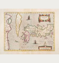
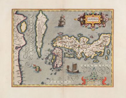
Iaponia
Jodocus Hondius (*1563 - †1612)Reference 12778
Description
A beautiful example of Hondius' map of Japan and Korea from the early 17th century. It shows one of the greatest cartographic myth with Korea depicted as an island. But Hondius expressing his doubts in the notes that Korea could be also a part of the mainland. Regarded as one of the earliest and finest Dutch maps of the area, it was first published in 1606. The map draws upon the Ortelius-Teixeira map of 1595 and depicts Korea as an island, along with the three main islands of Japan and a portion of China.
The map features decorative elements such as sea monsters, a Japanese junk, and a Dutch galleon. It can be distinguished from the later Janssonius edition, which replaces the junk with a European vessel.
Considered a significant milestone in Japanese cartography, this map served as the standard representation of the region until Martini's map of 1655.
Details
| Cartographer | Jodocus Hondius |
| Title | Iaponia |
| Publisher, Year | Henricus Hondius, Amsterdam, 1628 |
| Plate Size | 34.0 x 44.2 cm (13.4 x 17.4 inches) |
| Sheet Size | 47.9 x 56.7 cm (18.9 x 22.3 inches) |
| Reference | Van der Krogt, P.: Koeman's Atlantes Neerlandici, 8450:1A.1. |
Condition
Cartographer
Images to Download
If you like to download the image of this map with a resolution of 1200 pixels, please follow the link below.
You can use this image for publication on your personal or commercial websites for free if you set a link to this website. If you need photographs with a higher resolution, please contact us.

![Ch'onha Chido [Atlas of all under Heaven] Ch'onha Chido [Atlas of all under Heaven]](https://www.vintage-maps.com/3336-home_default/anonymous-korean-manuscript-atlas-chonha-chido-1820.jpg)
![Ch'onha Chido [Atlas of all under Heaven] Ch'onha Chido [Atlas of all under Heaven]](https://www.vintage-maps.com/4291-home_default/anonymous-korean-manuscript-atlas-chonha-chido-1800.jpg)
![Ch'onha chido [Atlas of all under Heaven] Ch'onha chido [Atlas of all under Heaven]](https://www.vintage-maps.com/3314-home_default/anonymous-korean-woodblock-atlas-chonha-chido-1750.jpg)
