Product successfully added to your shopping cart
There are 0 items in your cart. There is 1 item in your cart.
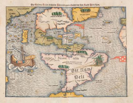
Die neüwen Inseln, so hinder Hispanien gegen Orient, bey dem Landt Indie ligen.
Sebastian Münster (*1489 - †1552)Reference 12836
Description
The first map to show the New World as an entity.
Earliest appearance of Japan on a map, predating European contact.
First appearance of Mare Pacificum on a map.
Sebastian Münster's first map of America, a groundbreaking depiction emerges - the first to showcase all of North and South America in a true continental form with a continuous coastline. This landmark map, published three years before European contact with Japan, offers a glimpse into the world as understood in the 16th century. This map of America is one of the most important maps in American cartography.
Philip Burden notes about this map:
The map's inclusion in Münster's Cosmography, first published in 1544, sealed the fate of 'America' as the name for the New World...
North America is portrayed as two almost separate land masses, connected by a slender strip of land. The eastern part was named Francisca after the journey of Giovanni di Verrazzano in 1524, since he was sent out by Francis I. The label C. Britonum in the southeastern part, acknowledging England's early exploration. The island Corterati off the coast of Francisca, likely corresponds to present-day Newfoundland. The larger western portion, the earliest to bear the name Florida, lacks detailed place names.
Heading south, the map unveils Mexico as Chamaho, and Yucatan is presented as an island. The Caribbean islands are marked with Spanish and Portuguese flags, reflecting the Treaty of Tordesillas. South America features intriguing details, including illustrations of cannibals (Canibali) in Brazil, the city of Catigara in Peru, and the mythical Regio Gigantum in Patagonia. The Strait of Magellan is already marked on the map as Fretum Magaliani[cum]. Magellan's ship Victoria, the only survivor of five vessels, appears in the middle of this ocean.
To the east lies the Atlantic Ocean, with Spain and Africa bordering the eastern edge. The Pacific Ocean (Mare Pacificum) makes its debut on a map with the modern name bestowed by Magellan. Marco Polo's influence can be seen with Zipangri (Japan) appearing three years before the earliest known contact with Europeans, and also his Archipelagus 7448 insularu is present. A mysterious island named Calensuan adds an enigmatic touch to the southwest border.
The woodblock of this map was first used in Seb. Münster's Geographia Universalis in 1540. Münster was one of the first to create space in the woodblocks for the insertion of place-names in metal type. In the follow the text was changed frequently and the identification of the different states of the map is possible. This example comes from the late German edition of Sebastian Münster's Cosmography, titled Cosmographey oder Beschreibung aller Länder Herrschafftenn, published 1578 by Heinrich Petri in Basel. This is the rare last state after Burden's 13rd state with the missing first three letters in the word Chamaho in Mexico, now only showing maho. This fact is also described in the 2023 update to Burden's The Mapping of North America. A crack or damage probably occurred at this point in the woodblock and the first part of the word became detached.
This map, beyond being the earliest to depict the Americas in true continental form, solidifies the name "America" for the New World. Münster's meticulous details, from geographical features to cultural references, provide a fascinating snapshot of early cartography and the evolving understanding of the world.
Details
| Cartographer | Sebastian Münster |
| Title | Die neüwen Inseln, so hinder Hispanien gegen Orient, bey dem Landt Indie ligen. |
| Publisher, Year | Heinrich Petri, Basle, 1540 (1578) |
| Plate Size | 25.5 x 34.2 cm (10.0 x 13.5 inches) |
| Sheet Size | 32.7 x 38.7 cm (12.9 x 15.2 inches) |
| Reference | Burden, P.D.: The Mapping of North America No. 12. |
Condition
Cartographer
Images to Download
If you like to download the image of this map with a resolution of 1200 pixels, please follow the link below.
You can use this image for publication on your personal or commercial websites for free if you set a link to this website. If you need photographs with a higher resolution, please contact us.
America Continent - Münster, Sebastian - Die neüwen Inseln, so hinder Hispanien...

![Aldenburg [Aldenbvrg] Aldenburg [Aldenbvrg]](https://www.vintage-maps.com/2177-home_default/muenster-germany-lower-saxony-stade-1574.jpg)
