Product successfully added to your shopping cart
There are 0 items in your cart. There is 1 item in your cart.
America sive India Nova ad magnae Gerardi Mercatoris avi universalis imitationem...
Michael Mercator (*1567 - †1600)Reference 12764
Description
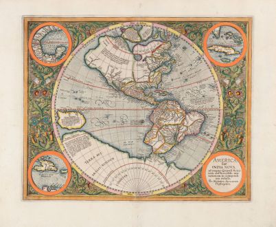
This striking map of the Western Hemisphere is a remarkable example of Michael Mercator's engraving skills. It is the only map he ever engraved, yet it displays exceptional artistry. The map is based on Rumold Mercator's world map from 1587 and first appeared in the Mercator Atlas of 1595.
The North and South American continents are depicted above a large southern continent. The Pacific Ocean extends to the west, with New Guinea positioned prominently at the edge of the hemisphere. In the northern region, three of the four islands typically placed around the North Pole by Gerard Mercator are visible.
The map features four insets in the corners, accompanied by decorative scrollwork that highlights Michael's engraving expertise. The upper left inset shows the Gulf of Mexico, the upper right depicts Cuba, the lower left shows Haiti (now known as Hispaniola), and the lower right contains the title. Although Gerard Mercator is mentioned in the title, Michael is identified as the engraver, and Duisburg is mentioned as the place where the work was executed.
The St. Lawrence River crosses half of the northern continent, while the search for a water passage across North America is interrupted by mid-continental mountains. Spanish explorations in the Southwest of North America are evident, and the Colorado and Gila Rivers demonstrate a good knowledge of this area, as does the peninsular shape of Baja California, based on Ulloa's work. In South America, the map provides detailed information about the Amazon and Rio de la Plata basins. The map incorporates several intriguing cartographic theories from the early modern period. These include the depiction of a large inland lake in Canada and a vast unknown southern continent. An outlined phantom treasure island off the western coast of South America is part of the El Dorado myth, and the giants of Patagonia are noted in the southern region. The toponym Anian regnum, derived from a Chinese province mentioned in Marco Polo's travels, marks the northwest region of North America, while the Strait of Anian indicates a clear passage from the Atlantic to the Pacific.
Although the map was engraved in 1595, it was clearly drawn earlier, as evidenced by certain details. For instance, there is no mention of the English presence in Virginia, and while Magellan and Columbus are referenced, explorers like Drake and Cavendish are not. The cartography of Hogenberg, Mazza, and Ortelius in the late 1580s, which influenced the shape of South America and the Pacific, has not yet impacted this hemisphere. As mentioned earlier, the map is based on Rumold's 1587 world map and serves as a posthumous tribute to Gerard Mercator.
Details
| Cartographer | Michael Mercator |
| Title | America sive India Nova ad magnae Gerardi Mercatoris avi universalis imitationem incompendium redacta |
| Publisher, Year | Henricus Hondius, Amsterdam, 1628 or 1633 |
| Plate Size | 36.7 x 45.5 cm (14.4 x 17.9 inches) |
| Sheet Size | 47.7 x 56.7 cm (18.8 x 22.3 inches) |
| Reference | Van der Krogt, P.: Koeman's Atlantes Neerlandici, 9000:1A; Burden, P.D.: The Mapping of North America No. 87 |
Condition
Cartographer
Images to Download
If you like to download the image of this map with a resolution of 1200 pixels, please follow the link below.
You can use this image for publication on your personal or commercial websites for free if you set a link to this website. If you need photographs with a higher resolution, please contact us.
America Continent - Mercator, Michael - America sive India Nova ad magnae Gerardi...


