Product successfully added to your shopping cart
There are 0 items in your cart. There is 1 item in your cart.
Reference 12412
Description
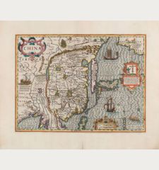
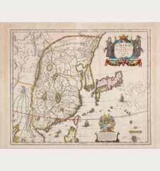
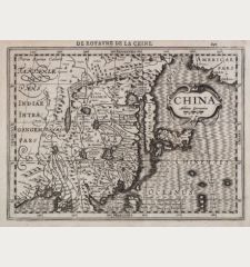
Impressive antique map of China, Japan and Korea by Jodocus Hondius. First published in the Mercator-Hondius Atlas of 1606.
At the beginning of the 17th century, little is known about this region in Europe. Hondius used Barbuda's map of China and Texeira's map of Japan as template. The result is an charming interplay of fiction and reality. Thus Japan deviates strongly from reality and Korea is depicted as an island. Within China several big lakes dominate, in the northeast of India the mythical Lake Chiang Mai (Chiamai Lacus) feeds five large rivers. The Great Wall of China is prominently displayed, also the position of the imperial palace, the Forbidden City, is indicated. Between Asia and America the mythical Strait of Anián is marked, in the upper right corner the northwest of America is shown and according to a note it is inhabited by Tartar hordes.
The map is decorated with three cartouches, one shows the persecution of Christian missionaries in Japan. Probably a reference to the 26 Martyrs of Japan, executed on Tateyama Hill in Nagasaki in 1567. To the left a Chinese land sailing vehicle, in the Pacific Ocean a sea monster, a European and a Japanese sailing ship, in the northwest of America two deer.
Hondius published the map for the first time in his Atlas sive Cosmographicae in 1606, this beautiful example comes from the Latin edition of 1623.
Details
| Cartographer | Jodocus Hondius |
| Title | China |
| Publisher, Year | Henricus Hondius, Amsterdam, 1623 |
| Plate Size | 34.2 x 45.7 cm (13.5 x 18.0 inches) |
| Sheet Size | 42.0 x 53.5 cm (16.5 x 21.1 inches) |
| Reference | Van der Krogt, P.: Koeman's Atlantes Neerlandici, 8410:1A |
Condition
Cartographer
Images to Download
If you like to download the image of this map with a resolution of 1200 pixels, please follow the link below.
You can use this image for publication on your personal or commercial websites for free if you set a link to this website. If you need photographs with a higher resolution, please contact us.


![Ch'onha Chido [Atlas of all under Heaven] Ch'onha Chido [Atlas of all under Heaven]](https://www.vintage-maps.com/3336-home_default/anonymous-korean-manuscript-atlas-chonha-chido-1820.jpg)
![Ch'onha Chido [Atlas of all under Heaven] Ch'onha Chido [Atlas of all under Heaven]](https://www.vintage-maps.com/4291-home_default/anonymous-korean-manuscript-atlas-chonha-chido-1800.jpg)
![Ch'onha chido [Atlas of all under Heaven] Ch'onha chido [Atlas of all under Heaven]](https://www.vintage-maps.com/3314-home_default/anonymous-korean-woodblock-atlas-chonha-chido-1750.jpg)
