Product successfully added to your shopping cart
There are 0 items in your cart. There is 1 item in your cart.
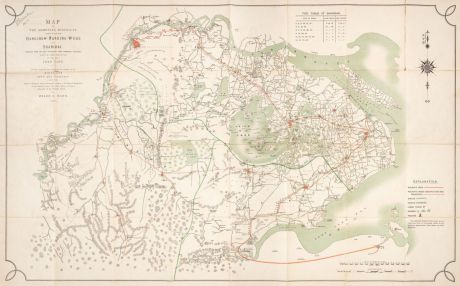
Map of the Shooting Districts lying between Hangchow - Nanking - Wuhu and Shanghai...
Fred & Helen Mann (*1817 - †1881)Reference 12835
Description
A Large and Very Detailed Map of the Shanghai Region.
This expansive and detailed map of Shanghai and its surroundings was created with a unique purpose - assisting a gentleman in finding optimal areas for game shooting. The map showcases game areas, roads, distinctive trees, and villages, along with prominent landmarks. Beyond traditional geographical labels, the map is adorned with phrases like "used by junks in summer", "used all the year round by river steamers" or "first-rate shooting country".
Covering a vast region from modern-day Tongling to Shanghai in the west to east direction, and from Nanjing to Hangzhou in the north to south direction, the map is labeled in both English and Chinese. It features major districts and provinces, marked railway lines (existing, under construction, or planned), cities, towns, villages, swamps, pagodas, hills, boundary provinces, creeks, canals and distinctive trees. Additionally, there's a note about the famous Hangzhou Bore, and a tide table for Shanghai is situated in the upper right corner.
Multicolored printed lithographic folding map, mounted on linen. In the original blue cloth binding with gilt lettering on the upper cover.
Details
| Cartographer | Fred & Helen Mann |
| Title | Map of the Shooting Districts lying between Hangchow - Nanking - Wuhu and Shanghai compiled from the latest authorities with numerous additions... By the late Fred Mann |
| Publisher, Year | Shanghai, 1909 |
| Plate Size | 71.0 x 116.0 cm (28.0 x 45.7 inches) |
| Sheet Size | 75.5 x 120.0 cm (29.7 x 47.2 inches) |
Condition
Cartographer
Images to Download
If you like to download the image of this map with a resolution of 1200 pixels, please follow the link below.
You can use this image for publication on your personal or commercial websites for free if you set a link to this website. If you need photographs with a higher resolution, please contact us.
China - Mann, Fred & Helen - Map of the Shooting Districts lying...

![Ch'onha Chido [Atlas of all under Heaven] Ch'onha Chido [Atlas of all under Heaven]](https://www.vintage-maps.com/3336-home_default/anonymous-korean-manuscript-atlas-chonha-chido-1820.jpg)
![Ch'onha Chido [Atlas of all under Heaven] Ch'onha Chido [Atlas of all under Heaven]](https://www.vintage-maps.com/4291-home_default/anonymous-korean-manuscript-atlas-chonha-chido-1800.jpg)
![Ch'onha chido [Atlas of all under Heaven] Ch'onha chido [Atlas of all under Heaven]](https://www.vintage-maps.com/3314-home_default/anonymous-korean-woodblock-atlas-chonha-chido-1750.jpg)
