Product successfully added to your shopping cart
There are 0 items in your cart. There is 1 item in your cart.

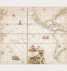
Novae Hispaniae, Chili, Peruviae, et Guatimalae Littorae
Reiner Ottens (*1698 - †1750)Reference 12044
Description
Large sea chart of Central and South America by Reiner & Joshua Ottens. Shows the eastern part of the Pacific with the northwest coast of South America to Valparaiso and South Mexico from Cap Corrientes. With the coasts of Honduras, Nicaragua, Costa Rica, Panama, Peru and Chile. Oriented to the east. Decorated with rhumb lines, two compass roses, sailing ships, a title cartouche and a mileage scale.
From R. & J. Ottens' sea atlas Atlas van Zeevaart published in 1745. The map first appeared in atlases by F. de Wit, later also by L. Renard.
Details
| Cartographer | Reiner Ottens |
| Title | Novae Hispaniae, Chili, Peruviae, et Guatimalae Littorae |
| Publisher, Year | Reiner & Joshua Ottens, Amsterdam, 1745 |
| Plate Size | 48.3 x 55.2 cm (19.0 x 21.7 inches) |
| Sheet Size | 52.8 x 60.0 cm (20.8 x 23.6 inches) |
Condition
Cartographer
Images to Download
If you like to download the image of this map with a resolution of 1200 pixels, please follow the link below.
You can use this image for publication on your personal or commercial websites for free if you set a link to this website. If you need photographs with a higher resolution, please contact us.
Pacific Ocean - Ottens, Reiner - Novae Hispaniae, Chili, Peruviae, et...

