Product successfully added to your shopping cart
There are 0 items in your cart. There is 1 item in your cart.

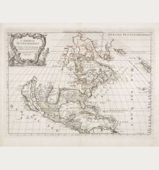
L'Amerique Septentrionale Dressee sur les Observations de Mrs. de l'Academie Royale des...
Guillaume de l'Isle (*1675 - †1726)Reference 12445
Description
Old coloured map of North America after Guillaume de l'Isle. This is the Covens & Mortier version of the important foundation map of North America by G. de l'Isle. California is again correctly depicted as a peninsula, the Great Lakes are based on Coronelli. French fortifications and settlements such as Fort Richelieu (Fort Sorel), Tadousac, Quebec and Montreal are already present. Compared to the map of de l'Isle, the routes of the explorers and navigators Drake, Cortés, Olivier van Noort and Mendana in the Pacific are included.
To the top left a splendid title cartouche with Neptune, Poseidon, a sea monster and shells.
Details
| Cartographer | Guillaume de l'Isle |
| Title | L'Amerique Septentrionale Dressee sur les Observations de Mrs. de l'Academie Royale des Sciences... Par G. de l'Isle... |
| Publisher, Year | Covens & Mortier, Amsterdam, circa 1730 |
| Plate Size | 47.0 x 58.3 cm (18.5 x 23.0 inches) |
| Sheet Size | 53.0 x 63.0 cm (20.9 x 24.8 inches) |
| Reference | Tooley, R.V.: The Mapping of America, No. 33 |
Condition
Cartographer
Images to Download
If you like to download the image of this map with a resolution of 1200 pixels, please follow the link below.
You can use this image for publication on your personal or commercial websites for free if you set a link to this website. If you need photographs with a higher resolution, please contact us.
North America - de l'Isle, Guillaume - L'Amerique Septentrionale Dressee sur les...

