Product successfully added to your shopping cart
There are 0 items in your cart. There is 1 item in your cart.
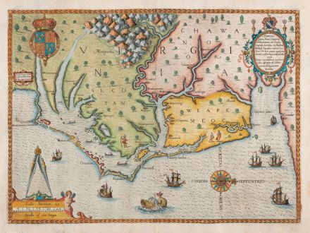
Americae Pars, Nunc Virginia Dicta, Primum ab Anglis Inventa Sumtibus Dn. Walteri...
Theodor de Bry (*1528 - †1598)Reference 11188
Description
One of the Most Significant Cartographical Milestones on Colonial North American History.
A very fine dark impression of the first printed map of Virginia and the Carolinas. From the first German edition of Theodor de Bry's Grand Voyages printed 1590 in Frankfurt. With unusual wide original margin.
Philip D. Burden in The Mapping of North America about this map (#76):
Theodor de Bry's map of Virginia, after John White, is one of the most significant cartographical milestones on colonial North American history. It was the most accurate map drawn in the sixteenth century of any part of that continent. It became the prototype of the area until long after James Moxon's map in 1671. Most notably those of de Jode 1593, Wytfliet 1597 and Metellus 1598. This is the first map to focus on Virginia (now largely North Carolina), and records the first English attempts at colonisation in the New World.
The map shows the area from Chesapeake Bay to Cape Lookout. It exhibits greater knowledge than on any surviving manuscript. With the first printing use of the name Chesapeake (Chesepiooc Sinus) and the second of Roanoke. The map shows the position of Indian villages, English ships are shown at sea, while Indian canoes traversing the inland waters.
This map comes from the first part of the first German edition of de Bry's Grand Voyages, titled Wunderbarliche, doch warhafftige Erklärung, von der Gelegenheit und Sitten der Wilden in Virginia .... This first edition was printed 1590 in Frankfurt. A second and a third German edition was published in 1600 and 1620. The Latin edition of de Bry's Grand Voyages with the title Admiranda narratio fida tamen, de commodis et incolarum ritibus Virginiae was published together with the German first edition in 1590.
Details
| Cartographer | Theodor de Bry |
| Title | Americae Pars, Nunc Virginia Dicta, Primum ab Anglis Inventa Sumtibus Dn. Walteri Raleigh Equestris Ordinis Viri Anno Dni. M.DLXXXV ... |
| Publisher, Year | Theodor de Bry, Frankfurt, 1590 |
| Plate Size | 30.5 x 41.8 cm (12.0 x 16.5 inches) |
| Sheet Size | 34.0 x 45.3 cm (13.4 x 17.8 inches) |
| Reference | Burden, P.D.: The Mapping of North America No. 76; Cumming, W.P.: The Southeast in Early Maps, No. 12; Stephenson, R.W. & McKee, M.M.: Virginia in Maps: Four Centuries of Settlement, Growth and Development, Map I-2. |
Condition
Cartographer
Theodor de Bry was a Flemish engraver and publisher, born in 1528 in Liege. 1578 he moved with his family to Frankfurt am Main, where he founded an engraving and publishing company.
In the years 1586 and 1588 he lived in London, where he worked with the geographer Richard Hakluyt. He collected travel reports and illustrations of European research expeditions. After his return in 1589, T. de Bry and his sons Johann Theodor and Johann Israel began to publish the two most important collections of Renaissance travelogue. Between 1590 and 1634, they published under the title America and the New World and India orientalis a comprehensive work out of 27 volumes, which are the most important travel books of the 16th Century. Equipped with large copper plate illustrations and explanatory text, a work arose that documents until today, how the countries of the Americas, Africa and Asia and its inhabitants looked like at the time of discovery and how the Europeans saw them.
Theodor de Bry was able to publish only six parts of his complete work. After his death in 1598, the work was continued by his sons and later by Johann Theodor's son-in-law Matthew Merian until 1634.
Images to Download
If you like to download the image of this map with a resolution of 1200 pixels, please follow the link below.
You can use this image for publication on your personal or commercial websites for free if you set a link to this website. If you need photographs with a higher resolution, please contact us.
North America - Bry, Theodor de - Americae Pars, Nunc Virginia Dicta, Primum...

