Product successfully added to your shopping cart
There are 0 items in your cart. There is 1 item in your cart.
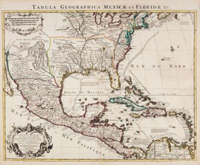
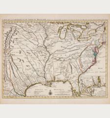
Carte Du Mexique et de la Floride des Terres Angloises et des Isles Antilles du Cours...
Covens and MortierReference 12432
Description
Beautiful old coloured antique map of the southeastern part of the United States with Mexico and the Caribbean Sea. Covens & Mortier's edition of De l'Isle's important map with an accurately depict of the course of the Mississippi River and its mouth. Florida extends beyond the Mississippi, the British colonies and New Mexico are mentioned. With the Gulf of Mexico and the Greater Antilles. Compared to De l'Isle's map, the routes of the Spanish galleons are added.
With two cartouches and a Latin title in the upper margin.
Details
| Cartographer | Covens and Mortier |
| Title | Carte Du Mexique et de la Floride des Terres Angloises et des Isles Antilles du Cours et des Environs de la Riviere Mississipi / Tabula Geographica Mexicae et Floridae |
| Publisher, Year | Covens & Mortier, Amsterdam, 1722 |
| Plate Size | 49.0 x 60.5 cm (19.3 x 23.8 inches) |
| Sheet Size | 53.0 x 63.8 cm (20.9 x 25.1 inches) |
Condition
Cartographer
Images to Download
If you like to download the image of this map with a resolution of 1200 pixels, please follow the link below.
You can use this image for publication on your personal or commercial websites for free if you set a link to this website. If you need photographs with a higher resolution, please contact us.
Central America - Caribbean - Covens and Mortier - Carte Du Mexique et de la Floride des...

![[West Indies, Jamaica, Hispaniola and South America] [West Indies, Jamaica, Hispaniola and South America]](https://www.vintage-maps.com/3035-home_default/bordone-central-america-caribbean-jamaica-hispaniola.jpg)
![[Lesser Antilles, West Indies] Guadalupe, Dominica, Matinina [Lesser Antilles, West Indies] Guadalupe, Dominica, Matinina](https://www.vintage-maps.com/3027-home_default/bordone-central-america-caribbean-guadeloupe-martinique.jpg)
