Product successfully added to your shopping cart
There are 0 items in your cart. There is 1 item in your cart.
Total products
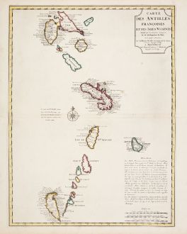
Carte des Antilles Francoises et des Isles Voisines...
Guillaume de l'Isle (*1675 - †1726)Old coloured map of the French West Indies, Lesser Antilles. Printed in Amsterdam by Covens & Mortier circa 1730.
Reference 12449
Description
Old coloured map of the French West Indies in the Eastern Caribbean after Guillaume de l'Isle. This is the Covens & Mortier version of the G. de l'Isle map. With the islands Guadeloupe, Dominica, Martinique, St. Lucia, St. Vincent, Barbados and Grenada. A title cartouche to the top right.
Details
| Cartographer | Guillaume de l'Isle |
| Title | Carte des Antilles Francoises et des Isles Voisines... |
| Publisher, Year | Covens & Mortier, Amsterdam, circa 1730 |
| Plate Size | 59.0 x 44.5 cm (23.2 x 17.5 inches) |
| Sheet Size | 63.5 x 53.0 cm (25.0 x 20.9 inches) |
Condition
Very good conditions with old colours. Never framed before.
Cartographer
The de L'Isle family was one of the most influential Geographers of the early 18th century in France. Claude de L'Isle, born 1644, had four sons, of which Guillaume was the most notable. Guillaume was born 1675 and became member of the Académie Royale des Sciences with the age of twenty-seven, and was honoured later with the title Premier Géographe du Roi. His largest project, the Atlas de Géographie, was published until 1774 in Paris and Amsterdam (Covens and Mortier). He died in 1726.
Images to Download
If you like to download the image of this map with a resolution of 1200 pixels, please follow the link below.
You can use this image for publication on your personal or commercial websites for free if you set a link to this website. If you need photographs with a higher resolution, please contact us.
Guillaume de l'Isle: Carte des Antilles Francoises et des Isles Voisines....
Old coloured map of the French West Indies, Lesser Antilles. Printed in Amsterdam by Covens & Mortier circa 1730.
Central America - Caribbean - de l'Isle, Guillaume - Carte des Antilles Francoises et des Isles...

![[West Indies, Jamaica, Hispaniola and South America] [West Indies, Jamaica, Hispaniola and South America]](https://www.vintage-maps.com/3035-home_default/bordone-central-america-caribbean-jamaica-hispaniola.jpg)
![[Lesser Antilles, West Indies] Guadalupe, Dominica, Matinina [Lesser Antilles, West Indies] Guadalupe, Dominica, Matinina](https://www.vintage-maps.com/3027-home_default/bordone-central-america-caribbean-guadeloupe-martinique.jpg)
