Product successfully added to your shopping cart
There are 0 items in your cart. There is 1 item in your cart.
Total products
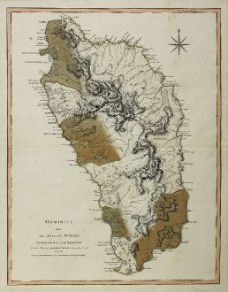
Dominica from An Actual Survey, Completed in the Year 1773 ... 1794
Laurie & WhittleOld coloured map of Dominica. Printed in London in the year 1794.
Reference 11443
Description
Large copper engraved map of Dominica, an island of the Lesser Antilles in the eastern Caribbean. From The West Indian Atlas by Thomas Jeffrey.
Details
| Cartographer | Laurie & Whittle |
| Title | Dominica from An Actual Survey, Completed in the Year 1773 ... 1794 |
| Publisher, Year | London, 1794 |
| Plate Size | 61.8 x 47.8 cm (24.3 x 18.8 inches) |
| Sheet Size | 66.0 x 51.9 cm (26.0 x 20.4 inches) |
Condition
Some browning on back side. Very good condition. Old colour.
Cartographer
Robert Laurie and James Whittle, engravers and publishers in London during the late 1700's. They had a partnership since 1794 and succeeded to the business carried on by Robert Sayer at the Golden Buck in Fleet Street, London.
Images to Download
If you like to download the image of this map with a resolution of 1200 pixels, please follow the link below.
You can use this image for publication on your personal or commercial websites for free if you set a link to this website. If you need photographs with a higher resolution, please contact us.
Laurie & Whittle: Dominica from An Actual Survey, Completed in the Year 1773 ... 1794.
Old coloured map of Dominica. Printed in London in the year 1794.
Central America - Caribbean - Laurie & Whittle - Dominica from An Actual Survey, Completed...

![[West Indies, Jamaica, Hispaniola and South America] [West Indies, Jamaica, Hispaniola and South America]](https://www.vintage-maps.com/3035-home_default/bordone-central-america-caribbean-jamaica-hispaniola.jpg)
![[Lesser Antilles, West Indies] Guadalupe, Dominica, Matinina [Lesser Antilles, West Indies] Guadalupe, Dominica, Matinina](https://www.vintage-maps.com/3027-home_default/bordone-central-america-caribbean-guadeloupe-martinique.jpg)
