Product successfully added to your shopping cart
There are 0 items in your cart. There is 1 item in your cart.
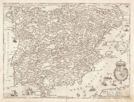
Nova Descriptio Hispaniae
Gerard de Jode (*1509 - †1591)Reference 12852
Description
This scarce map of Spain and Portugal originates from the renowned Italian architect Pirro Ligorio, as indicated at the top, and was engraved by Johannes and Lucas Doetecum for Gerard de Jode's Speculum Orbis Terrarum. The map is adorned with sea monsters and galleons. Our particular example hails from the first edition of the Speculum, published in 1578.
Geographically the map includes regions of Spain, Portugal, Galicia, Castile and Léon, Andalusia, Granada, Catalonia, Navarre, Aragon, Valencia, Murcia, and the Balearic Islands (Mallorca, Ibiza, and Formentera).
Gerard de Jode, a contemporary competitor of Ortelius, operated during the same period. However, his atlas, Speculum Orbis Terrarum, did not achieve the same commercial success as Ortelius, rendering De Jode's maps notably rarer today. Following Gerard's death in 1591, his widow and son Cornelis continued the business, reissuing the Speculum in 1593 with most plates newly engraved. Consequently, maps from the first edition, like the one in question, are exceptionally rare. After Cornelis's death in 1600, the printing plates were acquired by Vrients, the owner of Ortelius' plates, preventing their further reissue.
Details
| Cartographer | Gerard de Jode |
| Title | Nova Descriptio Hispaniae |
| Publisher, Year | G. de Jode, Antwerp, 1578 |
| Plate Size | 38.3 x 50.8 cm (15.1 x 20.0 inches) |
| Sheet Size | 41.4 x 55.2 cm (16.3 x 21.7 inches) |
| Reference | Van der Krogt, P.: Koeman's Atlantes Neerlandici, 6000:32:01 |
Condition
Cartographer
Images to Download
If you like to download the image of this map with a resolution of 1200 pixels, please follow the link below.
You can use this image for publication on your personal or commercial websites for free if you set a link to this website. If you need photographs with a higher resolution, please contact us.
Spain - Portugal - Jode, Gerard de - Nova Descriptio Hispaniae

![Tabula nova Hispaniae [Tabula noua Hispaniae] Tabula nova Hispaniae [Tabula noua Hispaniae]](https://www.vintage-maps.com/3236-home_default/fries-spain-portugal-1541.jpg)


![[Canary Islands] [Canary Islands]](https://www.vintage-maps.com/3021-home_default/bordone-spain-portugal-canaries-tenerife-gran-canaria.jpg)
