Product successfully added to your shopping cart
There are 0 items in your cart. There is 1 item in your cart.
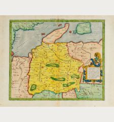
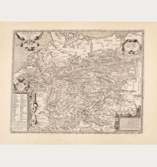
Germaniae Totius, Nostrae Europae Celeberrimae Regionis, Descriptio Singularis.
Gerard de Jode (*1509 - †1591)Reference 12661
Description
Scarce de Jode map of the Holy Roman Empire.
Rare map of Germany with the surrounding countries by Gerard de Jode. Showing the domain of the Roman-German emperors in the late 16th century. Rare, as it only appeared in the last edition of the Speculum Orbis Terrae, published two years after Gerard's death by his son Cornelius de Jode in 1593.
The map extends from the Netherlands to Poland and from Holstein in the north to Switzerland and northern Italy in the south. At the bottom left a large title cartouche with the Emperor enthroned, flanked by the seven Electors, each with a small coat of arms below.
Details
| Cartographer | Gerard de Jode |
| Title | Germaniae Totius, Nostrae Europae Celeberrimae Regionis, Descriptio Singularis. |
| Publisher, Year | Gerard de Jode, Antwerp, 1593 |
| Plate Size | 38.4 x 52.5 cm (15.1 x 20.7 inches) |
| Sheet Size | 40.2 x 54.6 cm (15.8 x 21.5 inches) |
| Reference | Van der Krogt, P.: Koeman's Atlantes Neerlandici, 2000:32B; Meurer, P.H.: Corpus der älteren Germania-Karten, 6.3.1 |
Condition
Cartographer
Images to Download
If you like to download the image of this map with a resolution of 1200 pixels, please follow the link below.
You can use this image for publication on your personal or commercial websites for free if you set a link to this website. If you need photographs with a higher resolution, please contact us.
Germany - Jode, Gerard de - Germaniae Totius, Nostrae Europae...


![[Donau Strom von Sigmaringen bis Donauwörth] [Donau Strom von Sigmaringen bis Donauwörth]](https://www.vintage-maps.com/2606-home_default/anonymous-germany-baden-wuerttemberg-danube-1702.jpg)


![[De Boemia. / Tabula quarta & quinta Europae de nonnullis / Germaniae ...] [De Boemia. / Tabula quarta & quinta Europae de nonnullis / Germaniae ...]](https://www.vintage-maps.com/2304-home_default/fries-germany-1541.jpg)
