Product successfully added to your shopping cart
There are 0 items in your cart. There is 1 item in your cart.
Total products
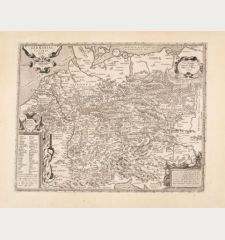
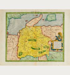
[Tabula IIII. Europae / Hae sunt e cognitis totius orbis Prouincijs seu Prefecturis...
Laurent Fries (*1485 - †1532)Antique woodcut map of Germany. Printed in Strasbourg by Johannes Grüninger in 1525.
Reference 11838
Description
Early woodcut map of Germany by Laurent Fries after Martin Waldseemüller. Showing the central part of Europe from Denmark to the Alps and from France to Poland. The origin of this map is the first so called "Modern Atlas" by Martin Waldseemuller since it is the first Ptolemy edition with twenty new regional maps beside the traditional twenty-seven Ptolemaic maps derived from the 1482 Ulm edition. The Atlas is titled Geographie opus Novissima Traductione e Grecorum Archetypis and published by Johann Schott in Strasbourg in 1513 and is one of the most important edition of the Ptolemy Atlases. In 1520 a second edition of the atlas was printed by Schott from the same woodcut blocks. It was reissued in 1522 and 1525 by Laurent Fries and Johannes Gruninger with size reduced maps. The wood blocks of Fries found their way into the ownership of Melchior and Gaspar Trechsel in Lyon. This map is the secound printing of the woodcut maps from the 1525 Strasbourg edition. The latin text on the verso of the map is flanked by ornate woodblock borders, which are said to be the work of Hans Holbein the Younger and Urs Graf.
Details
| Cartographer | Laurent Fries |
| Title | [Tabula IIII. Europae / Hae sunt e cognitis totius orbis Prouincijs seu Prefecturis quas quarta Europae tabula complectitur. Germania magna.] |
| Publisher, Year | Johannes Grüninger, Strasbourg, 1525 |
| Plate Size | 30.7 x 37.0 cm (12.1 x 14.6 inches) |
| Sheet Size | 39.5 x 53.5 cm (15.6 x 21.1 inches) |
| Reference | Karrow, R. W.: Mapmakers of the Sixteenth Century and their Maps, (16 c.) 28/33 |
Condition
Very good conditions.
Cartographer
Laurent Fries was a French physician and mathematician born around 1485 in Mulhouse. He settled finally in Strassburg where he meat Peter Apian and the publisher Johannes Grüninger which made him interested in the Ptolemy Atlas of 1513 and 1520. Fries made new woodcut maps in reduced size. His Ptolemy Atlas was published first in 1522, reissued in 1525, 1535 and 1541. He died in 1532.
Images to Download
If you like to download the image of this map with a resolution of 1200 pixels, please follow the link below.
You can use this image for publication on your personal or commercial websites for free if you set a link to this website. If you need photographs with a higher resolution, please contact us.
Laurent Fries: [Tabula IIII. Europae / Hae sunt e cognitis totius orbis Prouincijs seu Prefecturis quas quarta Europae tabula complectitur.....
Antique woodcut map of Germany. Printed in Strasbourg by Johannes Grüninger in 1525.
Germany - Fries, Laurent - [Tabula IIII. Europae / Hae sunt e...


![[Donau Strom von Sigmaringen bis Donauwörth] [Donau Strom von Sigmaringen bis Donauwörth]](https://www.vintage-maps.com/2606-home_default/anonymous-germany-baden-wuerttemberg-danube-1702.jpg)



![[De Boemia. / Tabula quarta & quinta Europae de nonnullis / Germaniae ...] [De Boemia. / Tabula quarta & quinta Europae de nonnullis / Germaniae ...]](https://www.vintage-maps.com/2304-home_default/fries-germany-1541.jpg)


![Tabula nova Hispaniae [Tabula noua Hispaniae] Tabula nova Hispaniae [Tabula noua Hispaniae]](https://www.vintage-maps.com/3236-home_default/fries-spain-portugal-1541.jpg)
![[Tab. Mo. Primae Partis Aphricae et Tabula Secunde partis Aphricae.] [Tab. Mo. Primae Partis Aphricae et Tabula Secunde partis Aphricae.]](https://www.vintage-maps.com/3651-home_default/fries-north-africa-1525.jpg)