Product successfully added to your shopping cart
There are 0 items in your cart. There is 1 item in your cart.
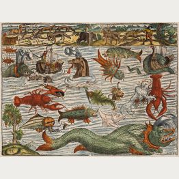
Sea Monsters

Chinae, olim Sinarum Regionis, nova descriptio. Auctore Ludovico Georgio.
A. Ortelius, Antwerp, circa 1587
Ortelius' Stunning Map of China with Old Colour.Old coloured map of China by Abraham Ortelius. The map is oriented to the west, north is on the right side. This is the first map of China ever...
Chinae, olim Sinarum Regionis, nova descriptio. Auctore Ludovico Georgio.
1587 - Abraham Ortelius
11521Old coloured map of China. Printed in Antwerp by A. Ortelius circa 1587.
3 400,00 €![Mercator, Italy, 1589 [1619]: Italia]( "Gerard Mercator: Italia")
Italia
Jodocus Hondius, Amsterdam, 1589 [1619]
Very nice old colored map of Italy by Gerard Mercator. With Sardinia and Corsica. Decorated with a beautiful title cartouche, a galleon and a sea monster.The first edition of the map was...
Italia
1589 - Gerard Mercator
12895Old coloured map of Italy. Printed in Amsterdam by Jodocus Hondius in 1619.
980,00 €
Hispalensis Conventus Delineatio Auctore Hieronymo Chiaves
Plantin Press, Antwerp, 1592
Beautiful old coloured antique map of Andalusia by A. Ortelius. Depicting Seville and its surroundings in Andalusia. With Córdoba, Écija, and Jerez de la Frontera. From the first modern atlas, the...
Hispalensis Conventus Delineatio Auctore Hieronymo Chiaves
1592 - Abraham Ortelius
12894Old coloured map of Seville, Andalusia. Printed in Antwerp by Plantin Press in 1592.
520,00 €
Situs Terrae Promissionis SS Bibliorum Intelligentiam Exacte Aperiens
A. Mylij, Cologne, 1593
A very large map of the Holy Land printed from two plates. From Christian van Adrichem's famous description of the Holy Land Theatrum Terrae Sanctae et Biblicarum Historiarum , printed 1593 in...
Situs Terrae Promissionis SS Bibliorum Intelligentiam Exacte Aperiens
1593 - Christian Adrichem
12135Antique map of the Holy Land. Printed in Cologne by A. Mylij in 1593.
950,00 €
Daniae regni typus / Cimbricae Chersonesi nunc Iutiae
Jan Baptist Vrients, Antwerp, 1602
Antique map of Denmark by A. Ortelius. Two maps on one sheet. The left map shows the entire Kingdom of Denmark with Schleswig-Holstein and the Baltic coast of Mecklenburg-Vorpommern in the south....
Daniae regni typus / Cimbricae Chersonesi nunc Iutiae
1602 - Abraham Ortelius
12763Antique map of Denmark. Printed in Antwerp by Jan Baptist Vrients in 1602.
590,00 €
Oldenburg Comit. / Thietmarsiae, Holsaticae Regionis Partis Typus
A. Ortelius, Antwerp, 1603
Old coloured antique map of Oldenburg country and Dithmarschen by A. Ortelius. Two maps on one sheet. The right map shows the Oldenburg country between Weser and East Friesland from Bremen to Jever...
Oldenburg Comit. / Thietmarsiae, Holsaticae Regionis Partis Typus
1603 - Abraham Ortelius
11856Old coloured map of Schleswig-Holstein, Lower Saxony. Printed in Antwerp by A. Ortelius in 1603.
490,00 €
Oldenburg Comit. / Thietmarsiae, Holsaticae Regionis Partis Typus
A. Ortelius, Antwerp, 1609-41
Old coloured antique map of Oldenburg country and Dithmarschen by A. Ortelius. Two maps on one sheet. The right map shows the Oldenburg country between Weser and East Friesland from Bremen to Jever...
Oldenburg Comit. / Thietmarsiae, Holsaticae Regionis Partis Typus
1609 - Abraham Ortelius
11847Old coloured map of Schleswig-Holstein, Lower Saxony. Printed in Antwerp by A. Ortelius in 1609.
450,00 €![van den Keere, Germany, 1615 [ 1632]: Nova Germaniae descriptio]( "Pieter van den Keere: Nova Germaniae descriptio")
Nova Germaniae descriptio
Johannes Janssonius, Amsterdam, 1615 [circa 1632]
Scarce Kerius map of the Holy Roman Empire with side panels.Very decorative and rare 'carte-à-figures' map of Germany with the surrounding countries by Pieter Kaerius (van den Keere). Shows...
Nova Germaniae descriptio
1615 - Pieter van den Keere
12657Coloured map of Germany. Printed in Amsterdam by Johannes Janssonius 1615 [circa 1632].
3 200,00 €![van den Keere, Spain - Portugal, 1616 [1640]: Nova Hispaniae Descriptio]( "Pieter van den Keere: Nova Hispaniae Descriptio")
Nova Hispaniae Descriptio
Johannes Janssonius, Amsterdam, 1616 [1640]
Scarce Kerius-Janssonius map of Spain with side panels.Very decorative and rare 'carte-à-figures' map of the Iberian Peninsula by Johannes Janssonius. The beautiful map of Spain and Portugal...
Nova Hispaniae Descriptio
1616 - Pieter van den Keere
12654Antique map of Spain - Portugal. Printed in Amsterdam by Johannes Janssonius in 1640.
3 500,00 €![Janssonius, Germany, 1616 [1632]: Nova Germaniae Descriptio]( "Johannes Janssonius: Nova Germaniae Descriptio")
Nova Germaniae Descriptio
Johannes Janssonius, Amsterdam, 1616 [1632]
Scarce Janssonius map of the Holy Roman Empire with side panels.Very decorative and rare 'carte-à-figures' map of Germany with the surrounding countries by Johannes Janssonius. First...
Nova Germaniae Descriptio
1616 - Johannes Janssonius
12783Coloured map of Germany. Printed in Amsterdam by Johannes Janssonius in 1632.
2 400,00 €
Typus Frisiae Orientalis à Dullarto ...
Pieter van den Keere, Amsterdam, 1622
One of the most beautiful maps of East Frisia.Rare and very decorative map of East Frisia (Ostfriesland) by Ubbo Emmius. Showing the North Sea coast of Friesland between Dollart and the Jade...
Typus Frisiae Orientalis à Dullarto ...
1622 - Pieter van den Keere
12662Antique map of East Frisia, Ostfriesland. Printed in Amsterdam by Pieter van den Keere in 1622.
1 150,00 €
Regni Valentiae typus
Amsterdam, 1623 or 1630
Antique map of Valencia by Jodocus Hondus. Shows the Spanish Mediterranean coast from Torrevieja to Tarragona. With Alicante, Xàbia, Dénia, Gandia, Castellón de la Plana and L'Ampolla. In the...
Regni Valentiae typus
1623 - Jodocus Hondius
12408Coloured map of Valencia. Printed in Amsterdam in 1623 or 1630.
420,00 €
China
Henricus Hondius, Amsterdam, 1623
Impressive antique map of China, Japan and Korea by Jodocus Hondius. First published in the Mercator-Hondius Atlas of 1606.At the beginning of the 17th century, little is known about this...
China
1623 - Jodocus Hondius
12412Coloured map of China. Printed in Amsterdam by Henricus Hondius in 1623.
2 200,00 €
India Orientalis
Henricus Hondius, Amsterdam, 1623
One of the Most Beautiful Early Maps of Southeast Asia.Antique map of the Indian subcontinent with the Philippines and parts of Indonesia by Jodocus Hondius. Shows Southeast Asia between...
India Orientalis
1623 - Jodocus Hondius
12649Coloured map of the Philippines, Thailand, China, India. Printed in Amsterdam by Henricus Hondius in 1623.
2 600,00 €
Iaponia
Henricus Hondius, Amsterdam, 1628
A beautiful example of Hondius' map of Japan and Korea from the early 17th century. It shows one of the greatest cartographic myth with Korea depicted as an island. But Hondius expressing his...
Iaponia
1628 - Jodocus Hondius
12778Coloured map of Japan - Korea. Printed in Amsterdam by Henricus Hondius in 1628.
2 400,00 €
China
Henricus Hondius, Amsterdam, 1628
Impressive antique map of China, Japan and Korea by Jodocus Hondius. First published in the Mercator-Hondius Atlas of 1606.At the beginning of the 17th century, little is known about this...
China
1628 - Jodocus Hondius
12779Coloured map of China. Printed in Amsterdam by Henricus Hondius in 1628.
2 700,00 €
Insularum Indiae Orientalis Nova Descriptio.
G. Valk and P. Schenk, Amsterdam, 1630 (1690)
Janssonius' map of Southeast Asia coloured by a contemporary hand. Re-issued by G. Valk and P. Schenk with modified title and signature. Decorated with three cartouches, two compass roses, ships...
Insularum Indiae Orientalis Nova Descriptio.
1630 - Johannes Janssonius
11276Old coloured map of Southeast Asia. Printed in Amsterdam by G. Valk and P. Schenk in 1690.
1 600,00 €
Indiae Orientalis Nova Descriptio
Henricus Hondius, Amsterdam, 1633
One of the Earliest Editions of Janssonius' Important Map of Southeast Asia.Johannes Janssonius' 1630 map is a significant early depiction of Southeast Asia, the Philippines, and Australia....
Indiae Orientalis Nova Descriptio
1633 - Johannes Janssonius
12773Coloured map of Southeast Asia. Printed in Amsterdam by Henricus Hondius in 1633.
Out of stock1 800,00 €
Africae nova tabula
Henricus Hondius, Amsterdam, 1633
Beautiful map of Africa by Henricus Hondius. This version of Jodocus Hondius' map depicts the continent without its decorative borders, which were removed to accommodate the atlas format. The...
Africae nova tabula
1633 - Jodocus Hondius
12776Coloured map of the African continent. Printed in Amsterdam by Henricus Hondius in 1633.
1 600,00 €
Insulae Indiae Orientalis Praecipuae, In quibus Moluccae celeberrime sunt
Henricus Hondius, Amsterdam, 1633
The Most Elegant and Decorative Map of the Region (Thomas Suarez)This map by the Dutch mapmaker Jodocus Hondius depicts the European knowledge of the East Indies, which became increasingly...
Insulae Indiae Orientalis Praecipuae, In quibus Moluccae celeberrime sunt
1633 - Jodocus Hondius
12777Coloured map of Southeast Asia. Printed in Amsterdam by Henricus Hondius in 1633.
3 600,00 €
Frisia occidentalis
H. Hondius, Amsterdam, 1633
Early map of West Frisia and Groningen by G. Mercator. The map extends from the islands of Schellinck to Borkum in the north, the province of Groningen in the east, the IJsselmeer and part of North...
Frisia occidentalis
1633 - Gerard Mercator
12818Coloured map of Frisia, West-Friesland, Groningen. Printed in Amsterdam by H. Hondius in 1633.
350,00 €
Italia nuovamente piu perfetta che mai per inanzi posta in luce.
H. Hondius, Amsterdam, 1633
Early map of Italy with rich decoration by J. Hondius. The map title is adorned with two caryatid-like women on either side. Below the ornate cartouche, the depiction of Rome's legendary founders,...
Italia nuovamente piu perfetta che mai per inanzi posta in luce.
1633 - Jodocus Hondius
12846Coloured map of Italy. Printed in Amsterdam by H. Hondius in 1633.
1 500,00 €
Portugalliae que olim Lusitania, novißima et exactißima descriptio, Auctore Vernando Alvaro Secco
H. Hondius, Amsterdam, 1633
This map of Portugal, dating back to the 17th century, is considered a notable example of cartographic craftsmanship from that period. Engraved by Baptista van Doetecum for the Mercator-Hondius...
Portugalliae que olim Lusitania, novißima et exactißima descriptio,...
1633 - Jodocus Hondius
12847Coloured map of Spain - Portugal. Printed in Amsterdam by H. Hondius in 1633.
700,00 €
Typus Hispaniae ab Hesselo Gerardo delineata...
H. Hondius, Amsterdam, 1633
This beautiful antique map of the iberian peninsula, dating back to the 17th century, depicts the geographical regions of Spain, including Portugal, Galicia, Castile and Léon, Andalusia, Granada,...
Typus Hispaniae ab Hesselo Gerardo delineata...
1633 - Jodocus Hondius
12848Coloured map of Spain - Portugal. Printed in Amsterdam by H. Hondius in 1633.
650,00 €

![Mercator, Italy, 1589 [1619]: Italia](https://www.vintage-maps.com/4424-home_default/mercator-italy-1589-1619.jpg "Gerard Mercator: Italia")


![van den Keere, Germany, 1615 [ 1632]: Nova Germaniae descriptio](https://www.vintage-maps.com/3840-home_default/van-den-keere-germany-1615--1632.jpg "Pieter van den Keere: Nova Germaniae descriptio")
![van den Keere, Spain - Portugal, 1616 [1640]: Nova Hispaniae Descriptio](https://www.vintage-maps.com/4046-home_default/van-den-keere-spain-portugal-1616-1640.jpg "Pieter van den Keere: Nova Hispaniae Descriptio")
![Janssonius, Germany, 1616 [1632]: Nova Germaniae Descriptio](https://www.vintage-maps.com/4143-home_default/janssonius-germany-1616-1632.jpg "Johannes Janssonius: Nova Germaniae Descriptio")


