Product successfully added to your shopping cart
There are 0 items in your cart. There is 1 item in your cart.
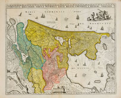
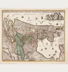
Comitatus Hollandiae Tabula Pluribus Locis Recens Emendata a Nicolao Visscher
Nicolas Visscher (*1618 - †1679)Reference 11829
Description
Antique map of Holland in the west of the Netherlands by N. Visscher. In the center Amsterdam, at the bottom left an inset map of the West Frisian islands Texel, Vlieland and Terschelling. In the IJsselmeer and Atlantic many sailing ships, a compass rose and mermaids with the coat of arms of the county of Holland.
The map first appeared in 1652 by Claes Jansz. Visscher. It was very popular and was copied by the cartographers P. Schenk, F. de Wit, C. Allard and J. Danckerts and published until the late 18th century. The map is based on the wall map of Balthasar Florisz of 1651. This copy corresponds to the fourth state of 1677.
Details
| Cartographer | Nicolas Visscher |
| Title | Comitatus Hollandiae Tabula Pluribus Locis Recens Emendata a Nicolao Visscher |
| Publisher, Year | N. Visscher, Amsterdam, 1677 |
| Plate Size | 46.3 x 56.0 cm (18.2 x 22.0 inches) |
| Sheet Size | 51.5 x 63.4 cm (20.3 x 25.0 inches) |
Condition
Cartographer
Images to Download
If you like to download the image of this map with a resolution of 1200 pixels, please follow the link below.
You can use this image for publication on your personal or commercial websites for free if you set a link to this website. If you need photographs with a higher resolution, please contact us.
Netherlands - Visscher, Nicolas - Comitatus Hollandiae Tabula Pluribus Locis...

![[Aa-Berlicum-Erp] [Aa-Berlicum-Erp]](https://www.vintage-maps.com/2588-home_default/anonymous-netherlands-river-aa-1780.jpg)
![[Kleve, Duisburg, Emmerich, Gennep] Cliviam, Ducatus Clivensis - Duisburgum - Embrica, Clivensis ditionis - Gennapium... [Kleve, Duisburg, Emmerich, Gennep] Cliviam, Ducatus Clivensis - Duisburgum - Embrica, Clivensis ditionis - Gennapium...](https://www.vintage-maps.com/3818-home_default/braun-hogenberg-north-rhine-westphalia-emmerich-duisburg-kleve.jpg)


![[Amsterdam] [Amsterdam]](https://www.vintage-maps.com/1930-home_default/muenster-netherlands-amsterdam-1574.jpg)
