Product successfully added to your shopping cart
There are 0 items in your cart. There is 1 item in your cart.
Total products
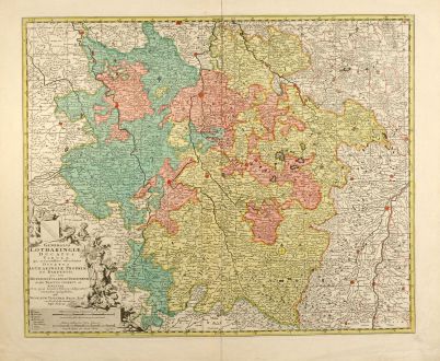
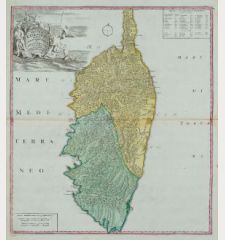
Generalis Lotharingiae Ducatus Tabula ...
Nicolas Visscher (*1618 - †1679)Old coloured map of the Lorraine. Printed in Amsterdam by N. Visscher circa 1680.
Reference 10494
Description
Original old copper engraved map of Lorraine in North-East France by N. Visscher. Covering the area around Metz, Nancy and Sarrebruck with Luxembourg in the North and Mulhouse in Southeast. With a decorative figurative and allegoric cartouche. From "Germania Inferior".
Details
| Cartographer | Nicolas Visscher |
| Title | Generalis Lotharingiae Ducatus Tabula ... |
| Publisher, Year | N. Visscher, Amsterdam, circa 1680 |
| Plate Size | 46.3 x 56.7 cm (18.2 x 22.3 inches) |
| Sheet Size | 49.7 x 65.3 cm (19.6 x 25.7 inches) |
Condition
Centrefold split backed, otherwise fine.
Cartographer
The Visscher family were art and map dealers in Amsterdam during the 17th century. Funded by C. J. Visscher (1587-1652), the business was continued by his son and grandson both named Nicolas. Nicolas Visscher I was born 1618 in Wenns, Austria. He died 1679 in Linz. After the death of Nicolas II, his widow passed the business to Pieter Schenk.
Images to Download
If you like to download the image of this map with a resolution of 1200 pixels, please follow the link below.
You can use this image for publication on your personal or commercial websites for free if you set a link to this website. If you need photographs with a higher resolution, please contact us.
Nicolas Visscher: Generalis Lotharingiae Ducatus Tabula ....
Old coloured map of the Lorraine. Printed in Amsterdam by N. Visscher circa 1680.
France - Visscher, Nicolas - Generalis Lotharingiae Ducatus Tabula ...


