Product successfully added to your shopping cart
There are 0 items in your cart. There is 1 item in your cart.
World Maps

Tabu. Nova Orbis / Diefert Situs Orbis Hydrographorum Ab Eo Quem Ptolomeus Posuit
M. & G. Trechsel, Lyon, 1535
The second 'modern' world map of L. Fries. 'This map is one of the earliest world maps available to a collector, and is an unsophisticated but attractive rendering of what was generally known of...
Tabu. Nova Orbis / Diefert Situs Orbis Hydrographorum Ab Eo Quem...
1535 - Laurent Fries
10865Antique woodcut map of the world. Printed in Lyon by M. & G. Trechsel in 1535.
Sold
Ptolemaisch General Tafel, begreiffend die halbe Kugel der Welt
Heinrich Petri, Basle, 1540 (1574)
Early Ptolemaic woodcut world map by Sebastian Münster. With a surround of clouds and wind-heads. Title on verso surrounded by a beautiful woodcut border. From the German edition of Sebastian...
Ptolemaisch General Tafel, begreiffend die halbe Kugel der Welt
1540 - Sebastian Münster
11322Ptolemaic woodcut world map by Sebastian Munster. Published by Heinrich Petri in Basel in 1574.
Sold
Ptolemaisch General Tafel, begreiffend die halbe Kugel der Weldt
Heinrich Petri, Basle, 1540 (1550)
Early Ptolemaic woodcut world map by Sebastian Münster. Surrounded by clouds and wind-heads. The title on verso is surrounded by a beautiful woodcut border. From the German edition of Sebastian...
Ptolemaisch General Tafel, begreiffend die halbe Kugel der Weldt
1540 - Sebastian Münster
12470Ptolemaic woodcut world map by Sebastian Munster. Published by Heinrich Petri in Basel in 1550.
Sold
Ptolemaisch General Tafel, begreiffend die halbe Kugel der Welt
Heinrich Petri, Basle, 1540 (1550)
Early Ptolemaic woodcut world map by Sebastian Münster. With a surround of clouds and wind-heads. Title on verso surrounded by a beautiful woodcut border. From the German edition of Sebastian...
Ptolemaisch General Tafel, begreiffend die halbe Kugel der Welt
1540 - Sebastian Münster
12609Ptolemaic woodcut world map by Sebastian Munster. Published by Heinrich Petri in Basel in 1550.
Sold
Nuevo Mundo
Francisco Frenandez de Cordova, Valladolid, 1545
Real First Edition of Medina's Very Rare Map of America and the Atlantic.Very rare and important first edition of the map of America and the Atlantic from Pedro de Medina's Arte de Navegar...
Nuevo Mundo
1545 - Pedro de Medina
12549Woodcut sea chart of the Atlantic Ocean. Printed in Valladolid by Francisco Frenandez de Cordova in 1545.
Sold![Ortelius, World Map, 1570 [1572]: Typus Orbis Terrarum]( "Abraham Ortelius: Typus Orbis Terrarum")
Typus Orbis Terrarum
Gielis Coppens van Diest, Antwerp, 1570 [1572]
The first World Map in the First Regular Atlas - with Old Colours.A fine old coloured and early example of one of the most famous world maps ever published. From the first modern atlas...
Typus Orbis Terrarum
1570 - Abraham Ortelius
12681Antique map of the world by Abraham Ortelius. Published in 1572 in Antwerp.
Sold
Descrittione del Mappamondo
Simon Galignani, Girolamo Porro, Venice, 1572
First edition of Porcacchi's antique map of the world. This is a finly-executed reduction of Camocio's large world map of 1567, one of the last in the long line of derivatives from Gastaldi's...
Descrittione del Mappamondo
1572 - Tomaso Porcacchi
12360Antique map of the world. Printed in Venice by Simon Galignani, Girolamo Porro in 1572.
Sold
Discorso Intorno alla Carta da Navigare
Simon Galignani, Girolamo Porro, Venice, 1572
First edition of the nautical chart of the world by T. Porcacchi. This finely-executed map shows a large part of the world, but in the east it only extends just beyond India. In the south a large...
Discorso Intorno alla Carta da Navigare
1572 - Tomaso Porcacchi
12361Antique map of the world. Printed in Venice by Simon Galignani, Girolamo Porro in 1572.
Sold
Ptolemaei Cognita
G. Ziletti, Venice, 1574
Attractive Ptolemaic worldmap of G. Ruscelli from "La Geografia di Claudio Tolomeo Alessandrino". Showing the known world described in the original Geography of Ptolemy around 100 D.C. The map is...
Ptolemaei Cognita
1574 - Girolamo Ruscelli
10327Antique map of the ptolemaic world. Printed in Venice by G. Ziletti in 1574.
Sold![Mercator, World Map, 1587 [1609]: Orbis Terrae Compendiosa Descriptio Quam ex Magna Universali Gerardi Mercatoris ... Rumoldus Mercator fieri curabat Ao....]( "Rumold Mercator: Orbis Terrae Compendiosa Descriptio Quam ex Magna Universali Gerardi Mercatoris ... Rumoldus Mercator fieri curabat Ao....")
Orbis Terrae Compendiosa Descriptio Quam ex Magna Universali Gerardi Mercatoris ... Rumoldus...
Jodocus Hondius, Amsterdam, 1587 [1609]
Rumold Mercator's Striking World Map.Old coloured double hemispherical world map by Rumold Mercator. The only world map available to collectors to which Rumold's famous father Gerhard...
Orbis Terrae Compendiosa Descriptio Quam ex Magna Universali Gerardi...
1587 - Rumold Mercator
12648Old coloured map of the world. Printed in Amsterdam by Jodocus Hondius in 1609.
Sold
Ptolemeisch General Tafel, die halbe Kugel der Welt begreiffende
Heinrich Petri, Basle, 1588
Ptolemaic woodcut world map by Sebastian Münster. With a surround of clouds and wind-heads. Title on verso with a beautiful woodcut vignette. This is the second ptolemaic world map of S. Münster...
Ptolemeisch General Tafel, die halbe Kugel der Welt begreiffende
1588 - Sebastian Münster
11588Ptolemaic woodcut world map by Sebastian Munster. Published by Heinrich Petri in Basel in 1588.
Sold
Typus Orbis Terrarum Ad Imitationem Universalis Gerhardi Mercatoris…
Johann Bussemacher, Cologne, 1596 (1608)
A rare and early world map of Mathias Quad. First published in Matthias Quad's Europae totius orbis terrarum in 1596. This example comes from the Fasciculus Geographicus printed by Johann...
Typus Orbis Terrarum Ad Imitationem Universalis Gerhardi Mercatoris…
1596 - Matthias Quad
11881Coloured map of the world. Printed in Cologne by Johann Bussemacher in 1608.
Sold
Orbis Terrae Compendiosa Descriptio ex ... Rumoldus Mercator ... Hieron: Porro redact
Matthias Quad, Cologne, 1604
Beautiful old hand coloured world map based on Rumold Mercator's world map of 1587. The map shows the classical late 16th Century configuration of the world with a large "Terrae Australis" in the...
Orbis Terrae Compendiosa Descriptio ex ... Rumoldus Mercator ... Hieron:...
1604 - Rumold Mercator
10578Classical late 16th Century World Map. Published by Matthias Quad in Cologne during the year 1604.
Sold![van den Keere, World Map, 1608 [1637-44]: Nova totius terrarum orbis geographica ac hydrographica tabula]( "Pieter van den Keere: Nova totius terrarum orbis geographica ac hydrographica tabula")
Nova totius terrarum orbis geographica ac hydrographica tabula
Amsterdam, 1608 [1637-44]
The Rare Kerius-Janssonius World Map After Blaeu.Perhaps the finest world map ever printed. This world map in Mercator projection, surrounded by four decorative borders, was engraved by...
Nova totius terrarum orbis geographica ac hydrographica tabula
1608 - Pieter van den Keere
12659Antique world map with borders by Pieter van den Keere. Published around 1640 in Amsterdam.
Sold![Blaeu, World and Continents, 1640: Nova Totius Terrarum Orbis Geographica ac Hydrographica Tabula auct: Guiljelmo Blaeuw [and] Africae nova descriptio [and]...]( "Willem Janszoon Blaeu: Nova Totius Terrarum Orbis Geographica ac Hydrographica Tabula auct: Guiljelmo Blaeuw [and] Africae nova descriptio [and]...")
Nova Totius Terrarum Orbis Geographica ac Hydrographica Tabula auct: Guiljelmo Blaeuw [and]...
Amsterdam, circa 1640
A matching set of the World and the Continents by Willem J. Blaeu These five maps represent the apogee of seventeenth century Dutch cartography. With their decorative panels of costumed figures,...
Nova Totius Terrarum Orbis Geographica ac Hydrographica Tabula auct:...
1640 - Willem Janszoon Blaeu
11061Old coloured world map and continent maps with borders by Willem J. Blaeu. Published around 1640 in Amsterdam.
Sold
Nova Totius Terrarum Orbis Geographica ac Hydrographica Tabula auct: Guiljelmo Blaeuw.
Amsterdam, 1643-50
One of the Most Famous World Maps of Dutch Cartography with Stunning Old Colours.Perhaps the finest world map ever printed. This map represents the apogee of seventeenth century Dutch...
Nova Totius Terrarum Orbis Geographica ac Hydrographica Tabula auct:...
1643 - Willem Janszoon Blaeu
11522Old coloured world map with borders by Willem J. Blaeu. Published 1643 in Amsterdam.
Sold
Orbis Terrarum Typus De Integro In Plurimis Emendatus Auctus et Icunculis Illustratus Auct....
Paulus Aertsz van Ravesteyn, Amsterdam, 1654
The First of a Series of World Maps to Be Found in Dutch Bibles.The rare first edition of Nicolas Visscher's beautiful world map from the Dutch Ravesteyn Bible of 1654. R. W. Shirley is only...
Orbis Terrarum Typus De Integro In Plurimis Emendatus Auctus et...
1654 - Nicolas Visscher
12738Rare world map by Nicolas Visscher. Published 1654 in Amsterdam.
Sold
Orbis Terrarum Tabula Recens Emendata et in Lucem Edita per N. Visscher
Visscher, Amsterdam, 1663
Attractive worldmap in double hemisphere with two inset astronomical diagrams. From a dutch bible. Surround with allegorical representation of the continents. Visschers second worldmap.
Orbis Terrarum Tabula Recens Emendata et in Lucem Edita per N. Visscher
1663 - Nicolas Visscher
10061Antique map of the world. Printed in Amsterdam by Visscher in 1663.
Sold
Orbis Terrarum Tabula Recens Emendata et in Lucem Edita per N. Visscher
Visscher, Amsterdam, 1663
Attractive coloured worldmap in double hemisphere with two inset astronomical diagrams. From a dutch bible. Surround with allegorical representation of the continents. Visschers second worldmap.
Orbis Terrarum Tabula Recens Emendata et in Lucem Edita per N. Visscher
1663 - Nicolas Visscher
10688Coloured map of the world. Printed in Amsterdam by Visscher in 1663.
Sold
Orbis Terrarum Tabula Recens Emendata et in Lucem Edita per N. Visscher
Visscher, Amsterdam, 1663
Beautiful coloured antique world map in double hemisphere with two inset astronomical diagrams. From the Elzevier Dutch bible printed in 1663. Surrounded with allegorical representation of the...
Orbis Terrarum Tabula Recens Emendata et in Lucem Edita per N. Visscher
1663 - Nicolas Visscher
11885Coloured map of the world. Printed in Amsterdam by Visscher in 1663.
Sold
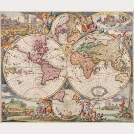
Nova Orbis Tabula, in Lucem Edita, A. F. De Wit
Frederick de Wit, Amsterdam, circa 1665
Beautiful double-hemisphere world map by Frederick de Wit. With two smaller maps of the North and South Pole surrounded by elaborate decoration. Vignettes of the four seasons in the corners and a...
Nova Orbis Tabula, in Lucem Edita, A. F. De Wit
1665 - Frederick de Wit
12555Antique world map by Frederick de Wit. Published in Amsterdam around 1665.
Sold
Nova Totius Terrarum Orbis Tabula ex Officina F. de Wit Amstelodami
Frederick de Wit, Amsterdam, 1668-70
Engraved by the Dutch Master Romeyn de Hooghe.Rare first state of Frederick de Wit's fine maritime world map. One of the most decorative world maps of the 17th century and maybe the best...
Nova Totius Terrarum Orbis Tabula ex Officina F. de Wit Amstelodami
1668 - Frederick de Wit
12419Antique world map by Frederick de Wit, engraved by Romeyn de Hooghe. Published in Amsterdam around 1668.
Sold![Valk, World Map, 1672 [1695]: Novus Planiglobii Terrestris per Utrumque Polum Conspectus]( "Gerard Valk: Novus Planiglobii Terrestris per Utrumque Polum Conspectus")
Novus Planiglobii Terrestris per Utrumque Polum Conspectus
Amsterdam, 1672 [1695]
The Most Interesting World Map of its Period.The mysterious final Blaeu world map in polar projection. Engraved by Joan Blaeu in 1672, but never published by himself because of the great...
Novus Planiglobii Terrestris per Utrumque Polum Conspectus
1672 - Gerard Valk
12554Old coloured map of the world by Joan Blaeu. Printed 1695 in Amsterdam by G. Valk.
Sold
Orbis Terrarum Tabula Recens Emendata et in Lucem Edita
circa 1680
World map from a Dutch bible of Daniel Stoopendael in beautiful hand colouring. The map is based on Nicolas Visscher's map of 1663. Showing double-hemisphere world map with two solar charts, one...
Orbis Terrarum Tabula Recens Emendata et in Lucem Edita
1680 - Daniel Stoopendaal
10689Coloured map of the world. Printed circa 1680.
Sold


![Ortelius, World Map, 1570 [1572]: Typus Orbis Terrarum](https://www.vintage-maps.com/3849-home_default/ortelius-world-map-1570-1572.jpg "Abraham Ortelius: Typus Orbis Terrarum")


![Mercator, World Map, 1587 [1609]: Orbis Terrae Compendiosa Descriptio Quam ex Magna Universali Gerardi Mercatoris ... Rumoldus Mercator fieri curabat Ao....](https://www.vintage-maps.com/3834-home_default/mercator-world-map-1587-1609.jpg "Rumold Mercator: Orbis Terrae Compendiosa Descriptio Quam ex Magna Universali Gerardi Mercatoris ... Rumoldus Mercator fieri curabat Ao....")


![van den Keere, World Map, 1608 [1637-44]: Nova totius terrarum orbis geographica ac hydrographica tabula](https://www.vintage-maps.com/3842-home_default/van-den-keere-world-map-1608-1637-44.jpg "Pieter van den Keere: Nova totius terrarum orbis geographica ac hydrographica tabula")
![Blaeu, World and Continents, 1640: Nova Totius Terrarum Orbis Geographica ac Hydrographica Tabula auct: Guiljelmo Blaeuw [and] Africae nova descriptio [and]...](https://www.vintage-maps.com/1213-home_default/blaeu-world-and-continents-1640.jpg "Willem Janszoon Blaeu: Nova Totius Terrarum Orbis Geographica ac Hydrographica Tabula auct: Guiljelmo Blaeuw [and] Africae nova descriptio [and]...")


![Valk, World Map, 1672 [1695]: Novus Planiglobii Terrestris per Utrumque Polum Conspectus](https://www.vintage-maps.com/3523-home_default/valk-world-map-1672-1695.jpg "Gerard Valk: Novus Planiglobii Terrestris per Utrumque Polum Conspectus")
