Product successfully added to your shopping cart
There are 0 items in your cart. There is 1 item in your cart.
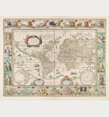
Nova totius terrarum orbis geographica ac hydrographica tabula
Pieter van den Keere (*1571 - †1650)Reference 12659
Description
The Rare Kerius-Janssonius World Map After Blaeu.
Perhaps the finest world map ever printed. This world map in Mercator projection, surrounded by four decorative borders, was engraved by Pieter van den Keere in Amsterdam in 1608 and represents the apogee of seventeenth century Dutch cartography. It is based on the map by Willem J. Blaeu published two years earlier, but compared to the Blaeu map it contains extensive annotations and far more information about possible discoveries in the Arctic, Antarctica and Australia. In contrast to the Blaeu world map, it is classified as rare (R) by Shirley.
R. Shirley describes this world map in The Mapping of the World, No. 264:
This map, signed by Pieter van den Keere using an abbreviation of his latinised name Petrus Kaerius and dated 1608, is an undisguised and skilful copy of Willem J. Blaeu's single-sheet world map of two years earlier. The clarity and precision of Keere's engraving is in no way inferior to that of Josua van den Ende who engraved Blaeu's map... A long note near the cartouche headed 'America' queries whether the straits of Anian and Davis do in fact link up to form a north-west passage. Keere's map, unlike the later states of Blaeu's, has strong rhumb lines radiating from three compass roses.
'The most striking characteristic are the superb border decorations. Along the top are allegorical of the sun and the moon and the known five planets - Mercury, Venus, Mars, Jupiter and Saturn. Down the sides are, on the left, four panels illustrating the elements (Fire, Water, Air and Earth), and on the right, the four seasons. Along the bottom are seven vignettes showing the seven ancient wonders of the world: the Hanging Gardens of Babylon, the Colossus over the harbour at Rhodos, the Pyramids, the Mausoleum of Halicarnassus at Caria, the Temple of Diane, the Statue of Jupiter, and the conical lighthouse of Alexandria.' (Shirley, Entry 255). The map has decorative cartouches for the title, dedication and explanation, two spheres for the north and south poles, three compass roses and numerous ships and sea monsters.
First published by Pieter van den Keere in 1608. The copper plate was sold to Johannes Janssonius before 1621, who used the world map only in a few early editions of his atlas. The strait of Le Maire east of Tierra del Fuego, discovered in 1616 by Jacob Le Maire and Willem Schouten, was added to the map in 1621. Around 1630, the date 1621 was removed from the cartouche under Janssonius' name. In the second half of the 17th century, the copper plate finally came to Moses Pitt, who heavily reworked and reissued it (see Shirley 504). This is the 4th of 5 states, published between 1637 and 1644 by Janssonius. Dutch text on verso.
Details
| Cartographer | Pieter van den Keere |
| Title | Nova totius terrarum orbis geographica ac hydrographica tabula |
| Publisher, Year | Amsterdam, 1608 [1637-44] |
| Plate Size | 39.9 x 55.0 cm (15.7 x 21.7 inches) |
| Sheet Size | 47.5 x 57.0 cm (18.7 x 22.4 inches) |
| Reference | Shirley, R. W.: The Mapping of the World, No. 264; Van der Krogt, P.: Koeman's Atlantes Neerlandici, 0001:1B.2; Schilder, G.: Monumenta Cartographica Neerlandica VI, 2.4. |
Condition
Cartographer
Images to Download
If you like to download the image of this map with a resolution of 1200 pixels, please follow the link below.
You can use this image for publication on your personal or commercial websites for free if you set a link to this website. If you need photographs with a higher resolution, please contact us.
World Maps - Keere, Pieter van den - Nova totius terrarum orbis geographica ac...

![Pieter van den Keere: Nova totius terrarum orbis geographica ac hydrographica tabula Antique Maps, van den Keere, World Map, 1608 [1637-44]: Nova totius terrarum orbis geographica ac hydrographica tabula](https://www.vintage-maps.com/3842-large_default/van-den-keere-world-map-1608-1637-44.jpg)
![Ch'onha Chido [Atlas of all under Heaven] Ch'onha Chido [Atlas of all under Heaven]](https://www.vintage-maps.com/3336-home_default/anonymous-korean-manuscript-atlas-chonha-chido-1820.jpg)
![Ch'onha Chido [Atlas of all under Heaven] Ch'onha Chido [Atlas of all under Heaven]](https://www.vintage-maps.com/4291-home_default/anonymous-korean-manuscript-atlas-chonha-chido-1800.jpg)
