Product successfully added to your shopping cart
There are 0 items in your cart. There is 1 item in your cart.
Total products
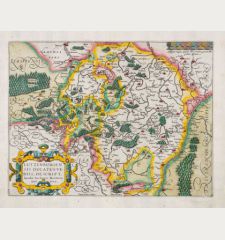
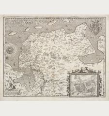
Lutzenburgensis Ducatus Veriss. Descript. Iacobo Surhonio Monta. Auct.
Pieter van den Keere (*1571 - †1650)Coloured map of Luxembourg. Printed in Amsterdam by Petrus Kaerius in 1617.
Reference 12558
Description
Rare antique map of Luxembourg by Petrus Kaerius. This is the first edition, dated 1617. In the east the Moselle from Metz to Trier, in the west the Meuse with Namur and Charleville-Mézières. To the lower left a city view of Luxembourg (Luxenburgum). Top left a title cartouche, to the lower right a mileage scale.
Details
| Cartographer | Pieter van den Keere |
| Title | Lutzenburgensis Ducatus Veriss. Descript. Iacobo Surhonio Monta. Auct. |
| Publisher, Year | Petrus Kaerius, Amsterdam, 1617 |
| Plate Size | 37.5 x 48.7 cm (14.8 x 19.2 inches) |
| Sheet Size | 44.0 x 54.8 cm (17.3 x 21.6 inches) |
Condition
Some browning. Excellent condition.
Cartographer
Pieter van den Keere, also Petrus Kaerius, was born in Ghent in 1571. At a young age he moved together with his family to London and was trained as an engraver by Jodocus Hondius. Like Hondius, he settled back to Amsterdam in 1593. He produced numerous copper engravings, besides those for Blaeu also for the Atlas Minor by J. Hondius. He published his own atlas of the Netherlands, Germania Inferior in 1617. In 1623 Claes Janszoon Visscher bought the copper plates of the atlas of the Netherlands and replaced Kaerius' name with his own.
Images to Download
If you like to download the image of this map with a resolution of 1200 pixels, please follow the link below.
You can use this image for publication on your personal or commercial websites for free if you set a link to this website. If you need photographs with a higher resolution, please contact us.
Pieter van den Keere: Lutzenburgensis Ducatus Veriss. Descript. Iacobo Surhonio Monta. Auct..
Coloured map of Luxembourg. Printed in Amsterdam by Petrus Kaerius in 1617.
Luxembourg - Keere, Pieter van den - Lutzenburgensis Ducatus Veriss. Descript....


