Product successfully added to your shopping cart
There are 0 items in your cart. There is 1 item in your cart.
Total products
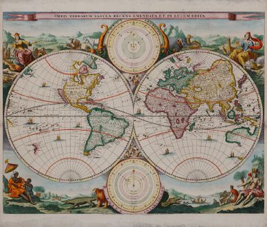
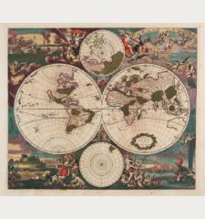
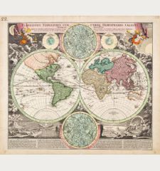
Orbis Terrarum Tabula Recens Emendata et in Lucem Edita
Daniel Stoopendaal (*1672 - †1726)Coloured map of the world. Printed in Rotterdam circa 1680.
Reference 11523
Description
Hand coloured world map from a Dutch bible by Daniel Stoopendael. The map is based on Nicolas Visscher's map of 1663. Showing double-hemisphere world map with two solar charts, one centred around the sun, the other earth-centred. Surrounded with allegorical representations of the continents. California as an island.
Details
| Cartographer | Daniel Stoopendaal |
| Title | Orbis Terrarum Tabula Recens Emendata et in Lucem Edita |
| Publisher, Year | Rotterdam, circa 1680 |
| Plate Size | 35.0 x 45.3 cm (13.8 x 17.8 inches) |
| Sheet Size | 39.6 x 47.4 cm (15.6 x 18.7 inches) |
| Reference | Shirley, R.W.: The Mapping of the World, No. 498 |
Condition
Mounted non reversible on thin card board. Good for framing. Very decorative.
Cartographer
Daniel Stoopendaal was born in 1672. He was active at Amsterdam between 1685 and 1713. He has drawn and etched to most famous houses and places of the Netherlands. Also he engraved maps for Dutch bibles. He died in 1726.
Images to Download
If you like to download the image of this map with a resolution of 1200 pixels, please follow the link below.
You can use this image for publication on your personal or commercial websites for free if you set a link to this website. If you need photographs with a higher resolution, please contact us.
Daniel Stoopendaal: Orbis Terrarum Tabula Recens Emendata et in Lucem Edita.
Coloured map of the world. Printed in Rotterdam circa 1680.
World Maps - Stoopendaal, Daniel - Orbis Terrarum Tabula Recens Emendata et...

![Ch'onha Chido [Atlas of all under Heaven] Ch'onha Chido [Atlas of all under Heaven]](https://www.vintage-maps.com/3336-home_default/anonymous-korean-manuscript-atlas-chonha-chido-1820.jpg)
![Ch'onha Chido [Atlas of all under Heaven] Ch'onha Chido [Atlas of all under Heaven]](https://www.vintage-maps.com/4291-home_default/anonymous-korean-manuscript-atlas-chonha-chido-1800.jpg)
