Product successfully added to your shopping cart
There are 0 items in your cart. There is 1 item in your cart.
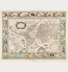
Nova Totius Terrarum Orbis Geographica Ac Hydrographica Tabula Auct. Henr: Hondio. . ....
Jodocus Hondius (*1563 - †1612)Reference 12775
Description
Rare Early Edition of the First State of One of the Most Famous World Maps of the 17th Century.
A very fine example of the first state of Henricus Hondius' celebrated world map. This is one of earliest edition of the first state of one of the most famous and ornately detailed world maps of the seventeens century, the first appearance in 1633 in the regular atlas after the first edition was published in the Appendix in 1630 without text on verso.
The bottom right cartouche bears the date 1630, indicating it as the first state of the map. Between 1630 and 1666, four different states of this map were identified. Its popularity led to its adoption as a base by other cartographers, although the Hondius example remain highly regarded for their intricate detail and ornamental design.
This map exemplifies the baroque-style Dutch cartography with its elaborate cartouches and whimsical illustrations. Mythical scenes and fantastical creatures adorn the borders, while the map itself showcases charming depictions of sailing vessels and sea monsters, enhancing its visual appeal.
Henricus Hondius, the mapmaker, was the son of the renowned cartographer Joducus Hondius, whose portrait is featured in the bottom left corner. The map also includes portraits of Gerardus Mercator, Claudius Ptolemy, and Julius Caesar. These portraits not only capture attention and hold historical significance but also establish the Dutch cartographic tradition (as exemplified by Hondius and Mercator) alongside the Roman cartographic lineage.
In addition to its numerous captivating illustrations and detailed map elements, this map highlights several notable geographic features. These include the portrayal of California as an island, the intricate river networks and lakes of North America, and the delineation of the Australian coastline.
During the sixteenth to eighteenth centuries, there was a widespread belief among Europeans that California was an island. This map reflects that belief, which diverges from earlier cartographers like Gerardus Mercator and Abraham Ortelius. They accurately depicted Baja California as a peninsula based on explorers' accounts in the mid- to late-sixteenth century, disproving the earlier claims of a sea separating California from the rest of North America. Since its first appearance on a printed map by Diego Gutiérrez in 1562, California has consistently been shown as part of North America.
This map shows significant changes in the northeast section of Canada, including the inclusion of Baffin Island, referred to as Queen Anne's forland. It also features an early depiction of the Mississippi River and the Great Lakes on the North American continent. Virginia and Florida are clearly labeled, and the regions discovered by Henry Hudson are named in the northern part. There is a large landmass identified as Nova Albion, popularized by Sir Francis Drake's accounts, which is depicted as reaching close to Japan. In the Sea of Cortez, there are two rivers flowing southwest, with an unnamed Rio Grande draining into the Sea of Cortez instead of the Gulf of Mexico.
In South America, the Le Maire Strait is now shown to the east of the Strait of Magellan. The Le Maire Strait was discovered only fifteen years before the publication of the first state of this map. Jacob Le Maire and Willem Schouten led a circumnavigation that aimed to challenge the trade monopoly of the Dutch East India Company (VOC). Their discovery of the strait provided an alternative route into the Pacific, bypassing the VOC-controlled Strait of Magellan.
At the bottom of the map, there is a faintly sketched representation of the mythic Terra Australis Incognita (Unknown Southern Land), a common feature in maps of that time. The place name Beach is located at the top of Terra Australis, an incorrect placement of an area later understood to be in Indo-China or the Malay Peninsula. The toponym originated from Marco Polo's writings. The inclusion of the Australian coast on this map marks the early stages of Dutch knowledge about the continent, capturing a moment when Terra Australis Incognita was gradually becoming known.
The map demonstrates the significant Dutch presence in Southeast Asia during this period. It provides detailed information about the region, reflecting the VOC's emphasis on exploration, trade, and resource acquisition. VOC merchants were tasked with mapping the areas they encountered, collecting valuable resources such as spices and minerals, and claiming resource-rich territories for the Dutch. The VOC, established in 1602 by the Dutch government as a consortium of independent merchants, initially focused its trading activities in India and expanded its empire eastward. While some VOC explorers were discovering Australia, others were venturing north of the company's base in Java, exploring the Philippines, Japan, and beyond.
Details
| Cartographer | Jodocus Hondius |
| Title | Nova Totius Terrarum Orbis Geographica Ac Hydrographica Tabula Auct. Henr: Hondio. . . . 1630 |
| Publisher, Year | Henricus Hondius, Amsterdam, 1633 |
| Plate Size | 38.0 x 54.0 cm (15.0 x 21.3 inches) |
| Sheet Size | 47.9 x 56.7 cm (18.9 x 22.3 inches) |
| Reference | Shirley, R. W.: The Mapping of the World, No. 336; Van der Krogt, P.: Koeman's Atlantes Neerlandici, 0001:1C.1 |
Condition
Cartographer
Images to Download
If you like to download the image of this map with a resolution of 1200 pixels, please follow the link below.
You can use this image for publication on your personal or commercial websites for free if you set a link to this website. If you need photographs with a higher resolution, please contact us.
World Maps - Hondius, Jodocus - Nova Totius Terrarum Orbis Geographica Ac...


![Ch'onha Chido [Atlas of all under Heaven] Ch'onha Chido [Atlas of all under Heaven]](https://www.vintage-maps.com/3336-home_default/anonymous-korean-manuscript-atlas-chonha-chido-1820.jpg)
![Ch'onha Chido [Atlas of all under Heaven] Ch'onha Chido [Atlas of all under Heaven]](https://www.vintage-maps.com/4291-home_default/anonymous-korean-manuscript-atlas-chonha-chido-1800.jpg)
