Product successfully added to your shopping cart
There are 0 items in your cart. There is 1 item in your cart.
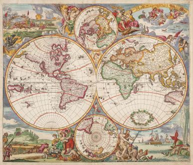
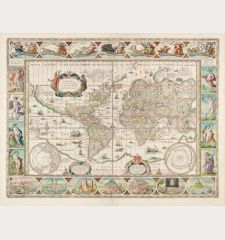
Nova Totius Terrarum Orbis Tabula Amstelodami per I. Danckerts cum Privil.
Justus Danckerts (*1635 - †1701)Reference 12859
Description
Very decorative double-hemisphere world map by Justus Danckerts. Based on Frederick De Wit's maritime world map of 1668. With two hemispheres and two small inset polar maps. Decorated with large and lively scenes allegorically representing the four elements fire, earth, water and air. Fire is shown by war and destruction; air by the heavens; earth by harvesting and husbandry; and water by ships and a spouting whale.
Justus Danckerts produced two world maps based on the maritime world map of Frederick de Wit (Shirley 444). For the first edition of 1680 (Shirley 495), Danckerts adapted both the geography and the decorative elements from De Wit almost unchanged. For this second world map of 1685 (Shirley 529), the title cartouche already contains the privilege granted to him in 1684. The outer decoration is once again very similar to that sourrounding De Wit's maritime world map, but the geography has numerous changes and additions.
The discoveries around Australia made by Tasman on his first and second expedition in 1642-44 are included again. New Zealand is once again drawn only by one coastline, New Guinea is now drawn as a large island and Danckerts has added the names of the oceans. California is still shown as an island, the west coast of North America beyond California has been added now. The lower polar map was completely revised. Now showing all the southern continents as far as the equator whereas previously only the southernmost tip of South America was depicted.
Crafted by the esteemed Danckerts family of Amsterdam, recognized as one of the most distinguished cartographic families in the 17th century, this map reflects the artistry of some of the world's finest draughtsmen and engravers. The Danckerts family is renowned for producing some of the finest atlases of the period, contributing significantly to the cartographic landscape. This particular copy stands out as a fine example, enhanced by meticulous watercoloring executed at the time of its creation.
Details
| Cartographer | Justus Danckerts |
| Title | Nova Totius Terrarum Orbis Tabula Amstelodami per I. Danckerts cum Privil. |
| Publisher, Year | J. Danckerts, Amsterdam, circa 1685 |
| Plate Size | 48.6 x 57.3 cm (19.1 x 22.6 inches) |
| Sheet Size | 51.0 x 59.7 cm (20.1 x 23.5 inches) |
| Reference | Shirley, R. W.: The Mapping of the World, No. 529 |
Condition
Cartographer
Images to Download
If you like to download the image of this map with a resolution of 1200 pixels, please follow the link below.
You can use this image for publication on your personal or commercial websites for free if you set a link to this website. If you need photographs with a higher resolution, please contact us.
World Maps - Danckerts, Justus - Nova Totius Terrarum Orbis Tabula...

![Ch'onha Chido [Atlas of all under Heaven] Ch'onha Chido [Atlas of all under Heaven]](https://www.vintage-maps.com/3336-home_default/anonymous-korean-manuscript-atlas-chonha-chido-1820.jpg)
![Ch'onha Chido [Atlas of all under Heaven] Ch'onha Chido [Atlas of all under Heaven]](https://www.vintage-maps.com/4291-home_default/anonymous-korean-manuscript-atlas-chonha-chido-1800.jpg)
