Product successfully added to your shopping cart
There are 0 items in your cart. There is 1 item in your cart.
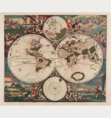
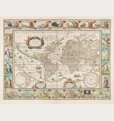
Nova Orbis Tabula, in Lucem Edita, A. F. De Wit
Frederick de Wit (*1630 - †1706)Reference 12555
Description
Beautiful double-hemisphere world map by Frederick de Wit. With two smaller maps of the North and South Pole surrounded by elaborate decoration. Vignettes of the four seasons in the corners and a title bar on top.
The discoveries around Australia made by Tasman on his first and second expedition in 1642-44 are included. New Zealand is drawn with one coastline only and California is still shown as an island.
R. Shirley describes this map in The Mapping of the World, Plate 333 (Entry 451), as follows:
De Wit's map is one of the most attractive of its time. The brilliant scenes in the corners combine images of the four seasons, the elements, and the signs of the zodiac in a well-balanced and naturalistic way.
This is the second state of De Wit's original plate. Around 1680 a second plate with additions and changes in the western hemisphere appeared. The map was also copied by Allard, Mortier and Loots.
Details
| Cartographer | Frederick de Wit |
| Title | Nova Orbis Tabula, in Lucem Edita, A. F. De Wit |
| Publisher, Year | Frederick de Wit, Amsterdam, circa 1665 |
| Plate Size | 47.6 x 56.4 cm (18.7 x 22.2 inches) |
| Sheet Size | 50.5 x 59.2 cm (19.9 x 23.3 inches) |
| Reference | Shirley, R. W.: The Mapping of the World, No. 451 |
Condition
Cartographer
Images to Download
If you like to download the image of this map with a resolution of 1200 pixels, please follow the link below.
You can use this image for publication on your personal or commercial websites for free if you set a link to this website. If you need photographs with a higher resolution, please contact us.
World Maps - Wit, Frederick de - Nova Orbis Tabula, in Lucem Edita, A. F....


![Ch'onha Chido [Atlas of all under Heaven] Ch'onha Chido [Atlas of all under Heaven]](https://www.vintage-maps.com/3336-home_default/anonymous-korean-manuscript-atlas-chonha-chido-1820.jpg)
![Ch'onha Chido [Atlas of all under Heaven] Ch'onha Chido [Atlas of all under Heaven]](https://www.vintage-maps.com/4291-home_default/anonymous-korean-manuscript-atlas-chonha-chido-1800.jpg)
