Product successfully added to your shopping cart
There are 0 items in your cart. There is 1 item in your cart.
Total products
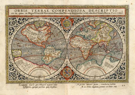
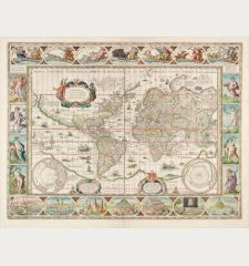
Orbis Terrae Compendiosa Descriptio ex ... Rumoldus Mercator ... Hieron: Porro redact
Rumold Mercator (*1541 - †1600)Classical late 16th Century World Map. Published by Matthias Quad in Cologne during the year 1604.
Reference 10578
Description
Beautiful old hand coloured world map based on Rumold Mercator's world map of 1587. The map shows the classical late 16th Century configuration of the world with a large "Terrae Australis" in the south, the Northwest passage with unusual shape of the North Pole and the bulky west coast of South America. Also the mythical islands in the Atlantic are present. From the 1604 Cologne edition of "Enchiridion cosmographicum" by Matthias Quad.
This map with another title was also use in Giovanni Magini's Ptolemy edition from 1596 and was engraved by Girolamo Porro. "It's the artist's credit that so much detail have been represented with such fineness and clarity... This small Mercator-Porro map is a worthwhile collector's item, particularly as the larger Mercator world map is becoming increasingly scarce." (R. Shirley)
This map with another title was also use in Giovanni Magini's Ptolemy edition from 1596 and was engraved by Girolamo Porro. "It's the artist's credit that so much detail have been represented with such fineness and clarity... This small Mercator-Porro map is a worthwhile collector's item, particularly as the larger Mercator world map is becoming increasingly scarce." (R. Shirley)
Details
| Cartographer | Rumold Mercator |
| Title | Orbis Terrae Compendiosa Descriptio ex ... Rumoldus Mercator ... Hieron: Porro redact |
| Publisher, Year | Matthias Quad, Cologne, 1604 |
| Plate Size | 16.4 x 23.7 cm (6.5 x 9.3 inches) |
| Sheet Size | 19.4 x 27.0 cm (7.6 x 10.6 inches) |
| Reference | Shirley 202 |
Condition
Minor soiling in margin. Otherwise perfect.
Cartographer
Rumold Mercator, the son of Gerard Mercator was also Geographer and responsible for the first complete edition of the Mercator Atlas in 1595. He was born 1541 in Louvain and died 1600 in Duisburg.
Images to Download
If you like to download the image of this map with a resolution of 1200 pixels, please follow the link below.
You can use this image for publication on your personal or commercial websites for free if you set a link to this website. If you need photographs with a higher resolution, please contact us.
Rumold Mercator: Orbis Terrae Compendiosa Descriptio ex ... Rumoldus Mercator ... Hieron: Porro redact.
Classical late 16th Century World Map. Published by Matthias Quad in Cologne during the year 1604.
World Maps - Mercator, Rumold - Orbis Terrae Compendiosa Descriptio ex ......

![Ch'onha Chido [Atlas of all under Heaven] Ch'onha Chido [Atlas of all under Heaven]](https://www.vintage-maps.com/3336-home_default/anonymous-korean-manuscript-atlas-chonha-chido-1820.jpg)
