Product successfully added to your shopping cart
There are 0 items in your cart. There is 1 item in your cart.
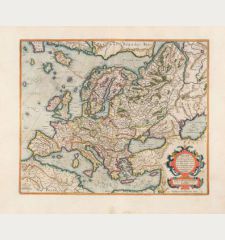
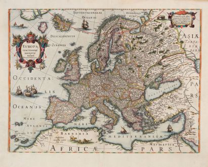
Europa Exactissime Descripta
Jodocus Hondius (*1563 - †1612)Reference 12767
Description
A beautiful example of Hondius' map of Europe with attractive colors.
The map provides a detailed depiction of Europe, including the names of cities, mountains, and rivers. It also features Greenland, Iceland, and the mythical island of Frislandt in the northern region, while extending to a portion of Africa in the south. Spanning from the Atlantic Ocean in the west to parts of Asia in the east, it showcases Russia and the entire eastern Mediterranean coast. The land is adorned with illustrations of lions in Africa and bears in Russia, while a sea monster and sailing ships traverse the ocean. The title is elegantly presented within a cartouche.
This particular map is based on Jodocus Hondius highly decorative map of Europe, first published in 1606, which included an illustrated frame. The initial state of the map, without the illustrated border, was published by Jodocus Hondius in 1619. Subsequently, it was published by his son Henricus in 1631, 1641, and 1645. The current example represents the secound state of the map, as described by Van der Krogt. It appeared in the French edition of the Atlas Novus, published in 1633.
Details
| Cartographer | Jodocus Hondius |
| Title | Europa Exactissime Descripta |
| Publisher, Year | Henricus Hondius, Amsterdam, 1633 |
| Plate Size | 38.0 x 50.7 cm (15.0 x 20.0 inches) |
| Sheet Size | 47.7 x 56.7 cm (18.8 x 22.3 inches) |
| Reference | Van der Krogt, P.: Koeman's Atlantes Neerlandici, 1000:1D.2 |
Condition
Cartographer
Images to Download
If you like to download the image of this map with a resolution of 1200 pixels, please follow the link below.
You can use this image for publication on your personal or commercial websites for free if you set a link to this website. If you need photographs with a higher resolution, please contact us.
Europe Continent - Hondius, Jodocus - Europa Exactissime Descripta


![[Map of Europe] [Map of Europe]](https://www.vintage-maps.com/2931-home_default/bordone-europe-continent-1528-1565.jpg)
