Product successfully added to your shopping cart
There are 0 items in your cart. There is 1 item in your cart.
Total products
The item shown below has already been sold. However, we have another example available:

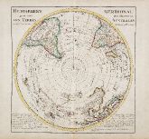
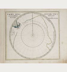
Hemisphere Meridional pour voir plus distinctement les Terres Australes
Guillaume de l'Isle (*1675 - †1726)Old coloured map of Australia, South Polar Region. Printed in Paris in the year 1714.
Reference 11296
Description
First edition of the important map of the southern hemisphere by de l'Isle in early strong colours, first published in 1714. This early map of the South Polar regions became the standard map for Dutch and French cartographers during the 18th Century and has been copied by Covens & Mortier, Buache, Dezauche and others.
The de l'Isle map is known for its meticulous presentation of the routes of the great discoveries of the 16th and 17th Century, including Magellan (1520), the first and second voyage of Mendaña (1568 and 1595), Quiros and Gallegos (1616), Le Maire (1616), Halley (1700), Dampier (1700), Louis S. (1708 ) and Tasman (1642). New Zealand and Australia with partly speculative coast lines.
The de l'Isle map is known for its meticulous presentation of the routes of the great discoveries of the 16th and 17th Century, including Magellan (1520), the first and second voyage of Mendaña (1568 and 1595), Quiros and Gallegos (1616), Le Maire (1616), Halley (1700), Dampier (1700), Louis S. (1708 ) and Tasman (1642). New Zealand and Australia with partly speculative coast lines.
Details
| Cartographer | Guillaume de l'Isle |
| Title | Hemisphere Meridional pour voir plus distinctement les Terres Australes |
| Publisher, Year | Paris, 1714 |
| Plate Size | 47.3 x 47.0 cm (18.6 x 18.5 inches) |
| Sheet Size | 53.4 x 71.5 cm (21.0 x 28.1 inches) |
| Reference | Tooley, R.V. (Australia) 1512, pl.110; Clancy, R. 6.26. |
Condition
Strong engraving on heavy paper. Two tears in upper margin backed. Very good conditions with nice contemporary colours
Cartographer
The de L'Isle family was one of the most influential Geographers of the early 18th century in France. Claude de L'Isle, born 1644, had four sons, of which Guillaume was the most notable. Guillaume was born 1675 and became member of the Académie Royale des Sciences with the age of twenty-seven, and was honoured later with the title Premier Géographe du Roi. His largest project, the Atlas de Géographie, was published until 1774 in Paris and Amsterdam (Covens and Mortier). He died in 1726.
Images to Download
If you like to download the image of this map with a resolution of 1200 pixels, please follow the link below.
You can use this image for publication on your personal or commercial websites for free if you set a link to this website. If you need photographs with a higher resolution, please contact us.
Guillaume de l'Isle: Hemisphere Meridional pour voir plus distinctement les Terres Australes.
Old coloured map of Australia, South Polar Region. Printed in Paris in the year 1714.
North - South Pole - de l'Isle, Guillaume - Hemisphere Meridional pour voir plus...

